Freezing Rain Tonight into Saturday Morning
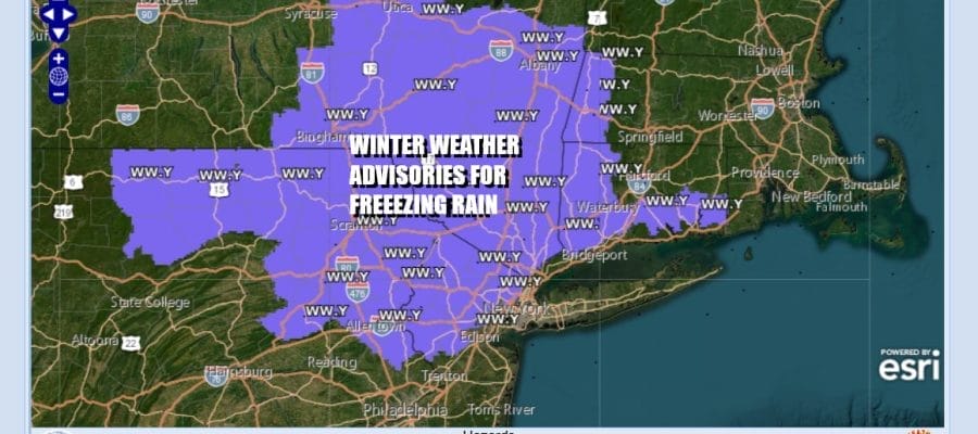
Winter Weather Advisories Northeast Pennsylvania to Connecticut

Freezing Rain Tonight into Saturday Morning
Winter Weather Advisories Northeast Pennsylvania to Connecticut
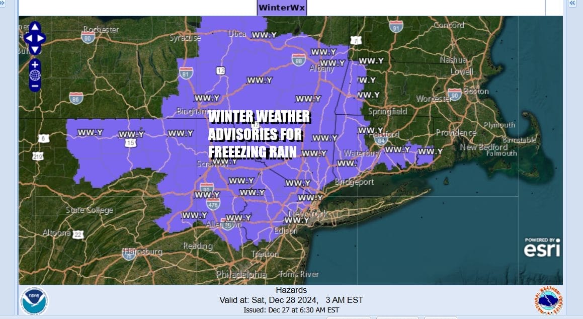
We have Winter Weather Advisories posted for overnight into Saturday morning for freezing rain and ice accretion. Advisories cover a large area in Eastern Pennsylvania as far south as Interstate 78. Also all of Northern New Jersey is under an advisory along and north of Interstate 78. The Catskills, the Hudson Valley and Connecticut are also part of this.
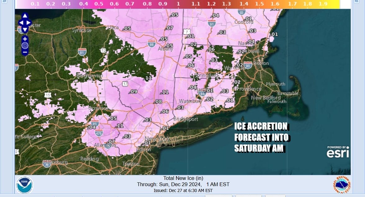
We are talking mostly light rain that will be moving through overnight into Saturday morning and ice accretion forecasts are for roughly .01 to .05 inch. The ground temperatures are very cold thanks to the long cold nights this week and that will likely create glazing of road surfaces overnight particularly in sheltered areas. No snow or sleet is involved in this system; it is all freezing rain. We should see temperatures begin to warm toward daybreak
SATELLITE WITH LIGHTNING STRIKES

WEATHER RADAR

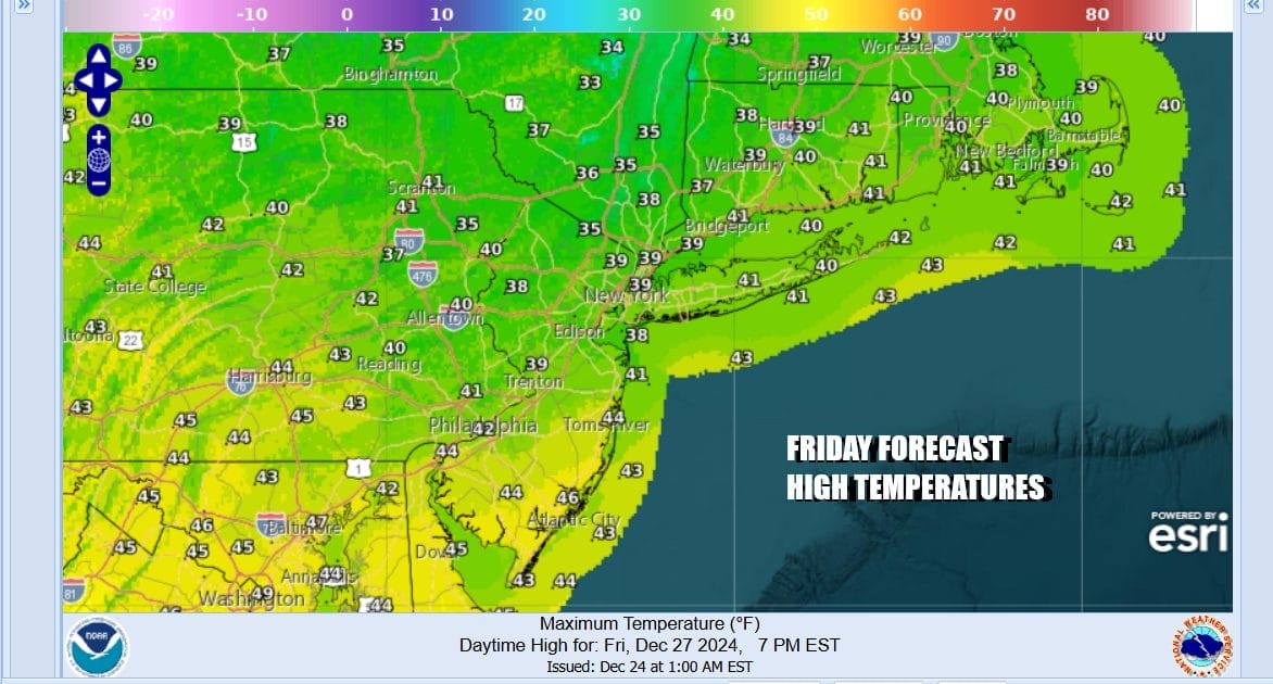
In the meantime today we will see sunshine. There will be some arriving clouds as a weather front to the west coupled with a warm front to the south head east and north respectively. However temperatures are going to have a bit of a tough time today and highs will probably only reach the mid to upper 30s in most places. We may not have much cloud cover this evening especially away from the coast and this could allow temperatures to settle in the upper 20s inland before any rain arrives.
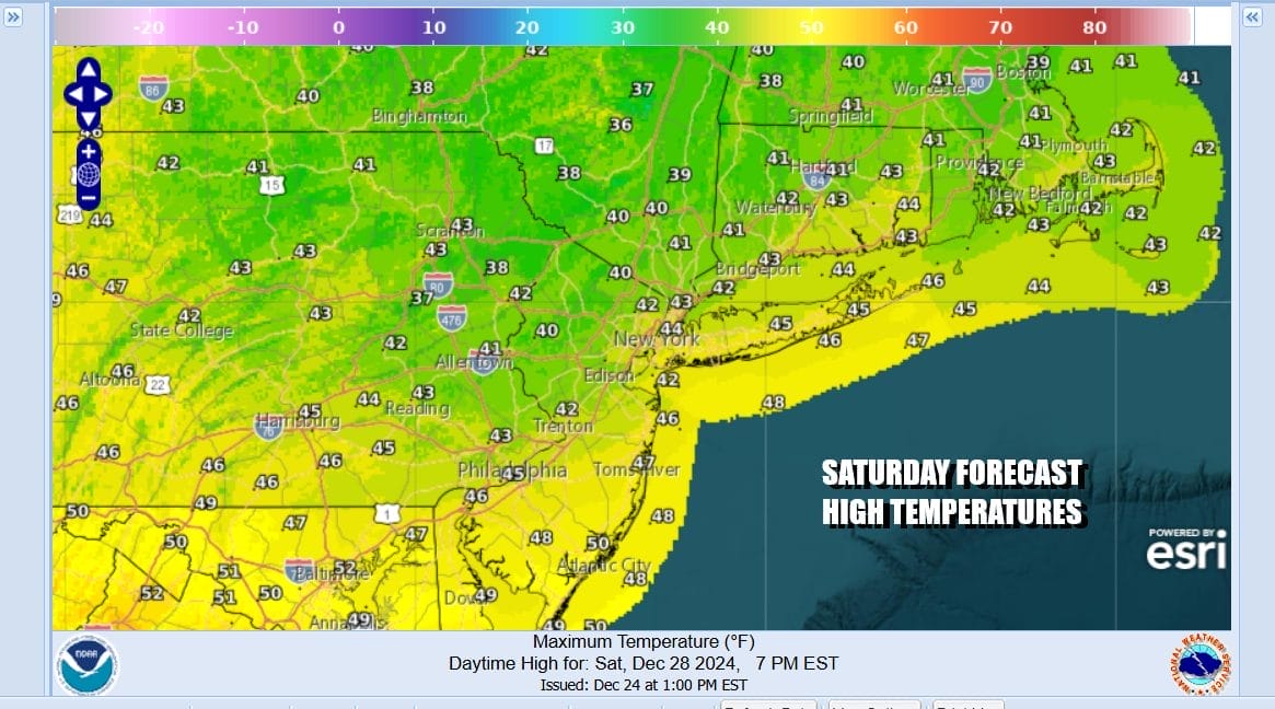
We will see some rain along the coast tonight and everyone goes to rain Saturday morning before this first round of precipitation ends midday to early afternoon. It will not clear out behind this because we have the cold front to deal with that will be approaching Sunday. Temperatures Saturday will rise above freezing. Highs will reach the low 40s well inland north and west and lower 50s South Jersey and points southward.
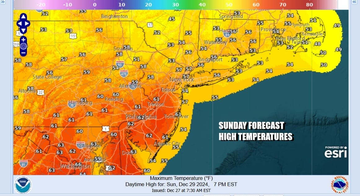
The warm front will continue to push northward Saturday night and we will see temperatures probably hold in the 40s to around 50 into Sunday morning. There will likely be fog around. The dayside Sunday may very well be dry with clouds and perhaps some sun breaking through the clouds at times. Highs will be in the warm mid 50s to lower 60s from north to south. Rain should hold off until late in the day or Sunday evening.
Sunday night into Monday morning we will see rain and then the cold front will pass through. This should allow us to dry out and weather conditions will improve during the day Monday. Another low will be coming out of the Plains and head eastward for Tuesday so clouds will be increasing again. Rain looks to come in for Tuesday night into Wednesday morning so the New Year will arrive wet and warm.

Temperatures Monday and Tuesday will be in the 50s. Once the New Year’s Eve/New Year’s Day system passes, a colder weather pattern will gradually develop over the entire eastern half of the US in the long range and we will see a stretch of below average temperatures develop late next week and beyond. Whether that comes with any snow threats in the long range remains to be seen.
BE SURE TO DOWNLOAD THE FREE METEOROLOGIST JOE CIOFFI WEATHER APP &
ANGRY BEN’S FREE WEATHER APP “THE ANGRY WEATHERMAN!
MANY THANKS TO TROPICAL TIDBITS FOR THE USE OF MAPS
Please note that with regards to any severe weather, tropical storms, or hurricanes, should a storm be threatening, please consult your local National Weather Service office or your local government officials about what action you should be taking to protect life and property.


