Gloom & Doom Rainy Foggy & Warmer Conditions Into Monday Morning
New Year Arrives Warm & Wet

Gloom & Doom Rainy Foggy & Warmer Conditions Into Monday Morning
New Year Arrives Warm & Wet
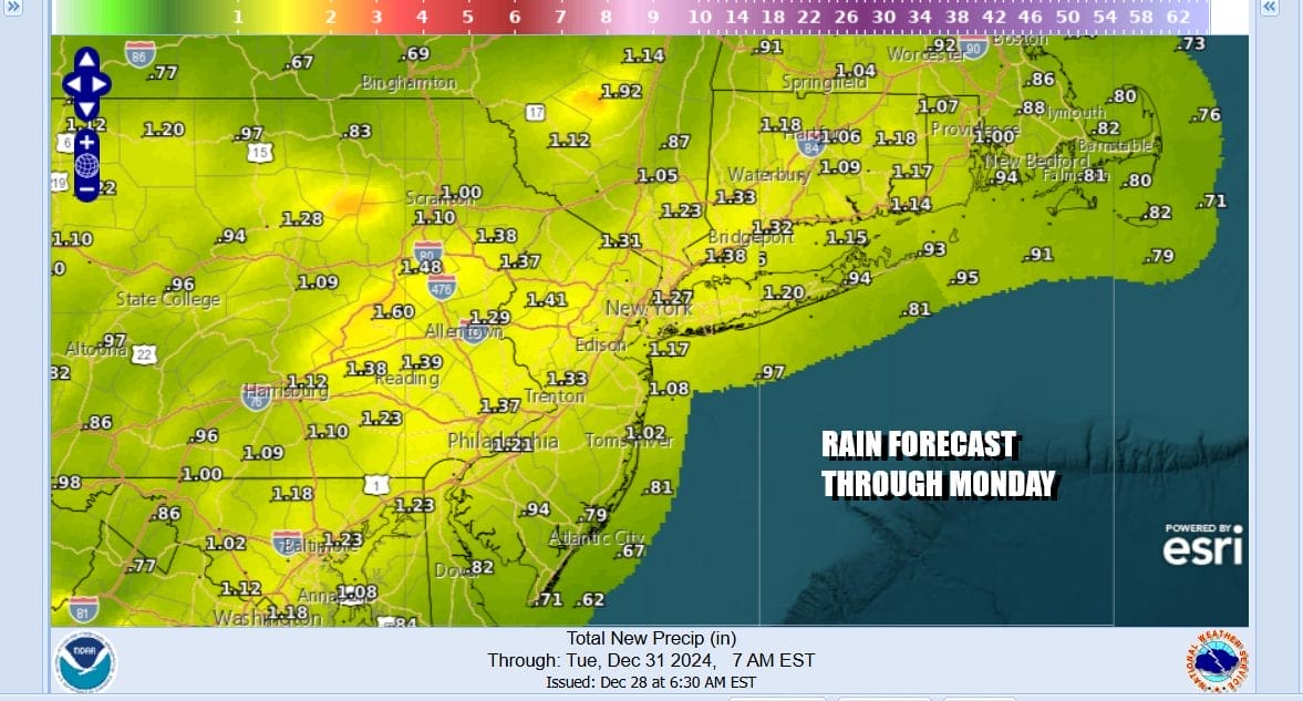
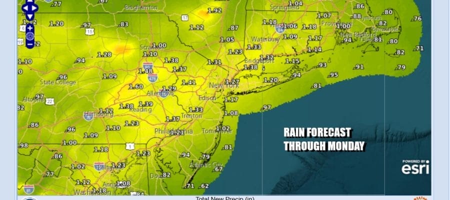
It is a weekend of gloom and doom as warmer air continues to push up the East Coast ahead of a warm front. Then we have low pressure in the Great Lakes with a trailing cold front that will be dealing with Sunday night into Monday morning. This is a recipe for gloom and doom conditions for the weekend. It won’t be raining all the time however. Rainfall amounts will be in the range of an inch to an inch a a half across the area when this is all said and done Monday morning.
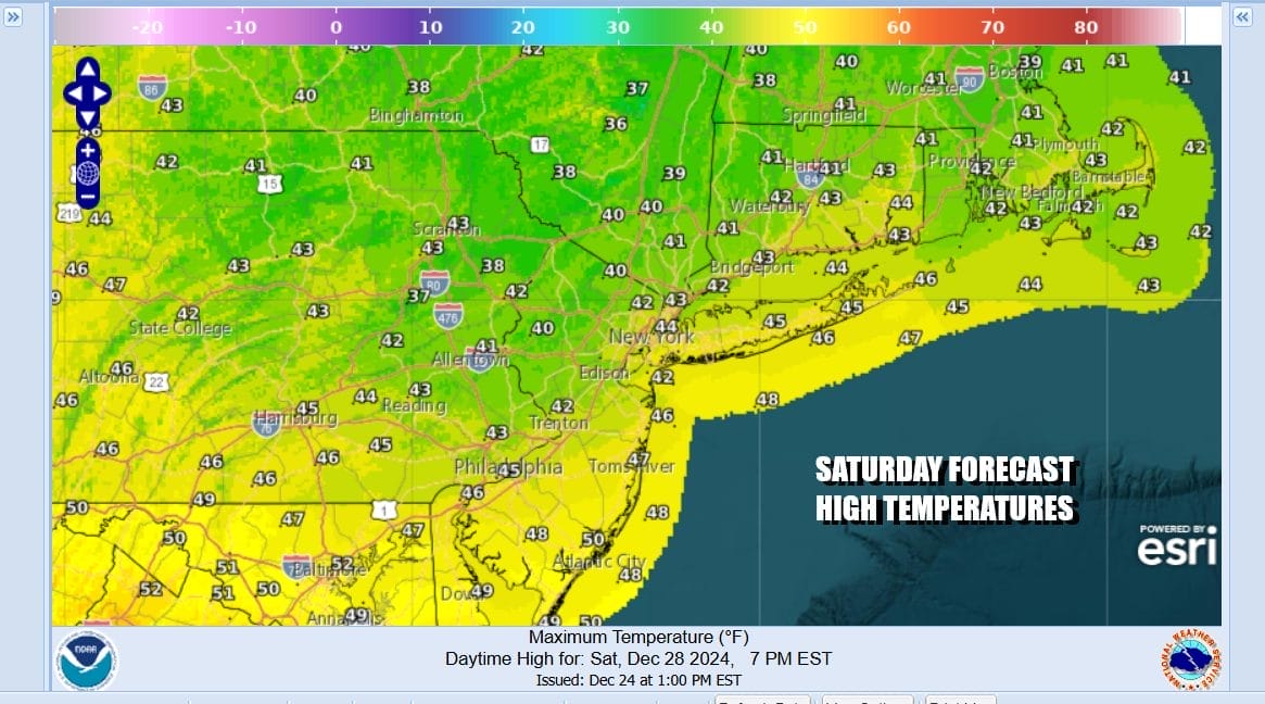
Meanwhile inland areas today north and northeast of NYC will be struggling to get rid of the leftover cold air of the past week. Precipitation moved in overnight and glazed up some areas with a little ice but that will change as the day wears on. Light precipitation be it rain or in some cases freezing rain inland will taper off and then we are left with lots of clouds. Temperatures today will not get much above the low and middle 40s to north and northeast of NYC while to the south across Southern New Jersey and Southeastern Pennsylvania we will likely push up to the lower 50s.
SATELLITE WITH LIGHTNING STRIKES

WEATHER RADAR

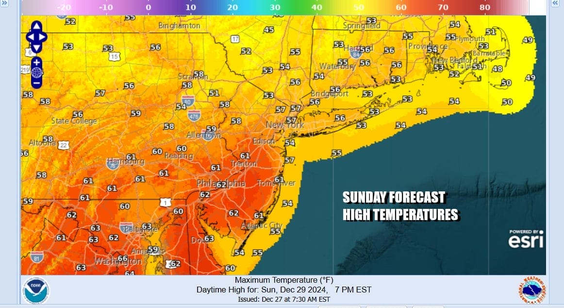
Warm fronts always seem to struggle when they reach our latitude and that is likely to happen tonight into Sunday morning. It will mean clouds, fog and some light rain overnight with nearly steady temperatures in the 40s. Sunday should see the warm frontal boundary push northward and that should push highs to the mid 50s and even some lower 60s are possible. There will be lots of clouds around along with some light rain early in the day.
Low pressure heading through the Great Lakes and Eastern Canada will push the cold front through so we will have rain Sunday night lasting into early Monday morning. I suppose a thunderstorm getting into the mix is not impossible. Once this system exits Monday morning we will see improvement but another storm system coming out of the Plains will head eastward.

There is no real cold air behind the cold front so the next weather system sets up for a round of rain Tuesday night into early New Years Day so 2025 arrives wet and on the warmish side. However all the longer range weather models show that after this system passes through, we will begin what will be a long duration stretch of colder than average temperatures that will cover much of the US east of Rockies. For now we do not see any obvious systems that may bring winter precipitation risks but it is likely that at some point in the next few weeks, we will be seeing winter exert its strength in one form or another.
BE SURE TO DOWNLOAD THE FREE METEOROLOGIST JOE CIOFFI WEATHER APP &
ANGRY BEN’S FREE WEATHER APP “THE ANGRY WEATHERMAN!
MANY THANKS TO TROPICAL TIDBITS FOR THE USE OF MAPS
Please note that with regards to any severe weather, tropical storms, or hurricanes, should a storm be threatening, please consult your local National Weather Service office or your local government officials about what action you should be taking to protect life and property.


