Freezing Rain Advisory NW NJ NE PA
Freezing Rain Advisory NW NJ NE PA

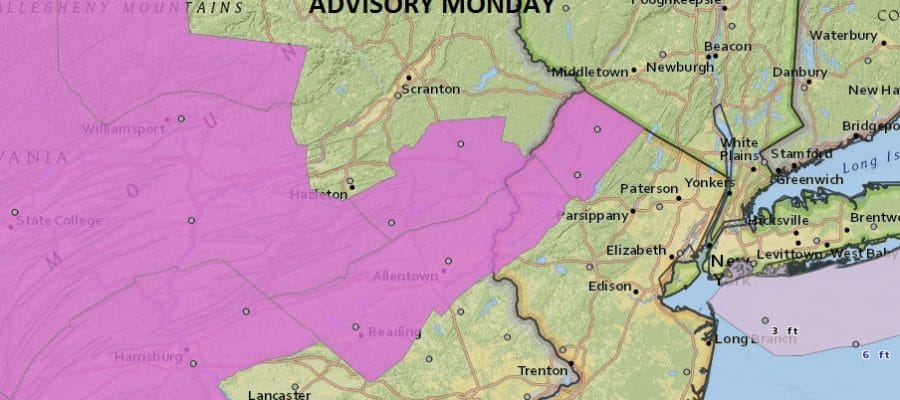
We have a freezing rain advisory that has been posted for NW New Jersey and parts of Northeast Pennsylvania for Monday. Colder air will be draining southward tonight from snow covered upstate NY and New England. This will mean that cold air will get trapped in the above areas and there could be some light glazing that will occur. Fortunately the amount of precipitation forecast will be on the light side so this will not be an all out ice storm situation. Also I would be cautious in the Hudson Valley and in interior Connecticut as temperatures here could also be close to the freezing mark at least for awhile.


Through this evening and for tonight there are no serious weather issues to worry about. Skies will be clear for part of the night and that should allow temperatures to fall below freezing inland. Once the first area of rain moves out we will see a larger more abundant area of rain come in later Monday night and last through Tuesday night as low pressure redevelops just offshore. By later Monday night temperatures will be above freezing area and we should see a good soaking rain here on the order of an inch or more for Tuesday.
Wednesday we start drying out and turning colder. Weather models this afternoon continue to overwhelm the area with cold air which will suppress storm activity to the south and east, at least that is the plan at the moment. JOESTRADAMUS has more on that in his latest longer range post.
SNOW REMOVAL COMPANIES FOR YOUR WINTER NEEDS
LONG ISLAND ROCKLAND COUNTY Connecticut

![]()

ROCKLAND COUNTY TRI STATE SNOW REMOVAL JOHNSTOWN PA


FiOS1 News Weather Forecast For Long Island
FiOS1 News Weather Forecast For New Jersey
FiOS1 News Weather Forecast For Hudson Valley
NATIONAL WEATHER SERVICE SNOW FORECASTS
LATEST JOESTRADAMUS ON THE LONG RANGE
Weather App

Don’t be without Meteorologist Joe Cioffi’s weather app. It is really a meteorologist app because you get my forecasts and my analysis and not some automated computer generated forecast based on the GFS model. This is why your app forecast changes every 6 hours. It is model driven with no human input at all. It gives you an icon, a temperature and no insight whatsoever.
It is a complete weather app to suit your forecast needs. All the weather information you need is right on your phone. Android or I-phone, use it to keep track of all the latest weather information and forecasts. This weather app is also free of advertising so you don’t have to worry about security issues with your device. An accurate forecast and no worries that your device is being compromised.
Use it in conjunction with my website and my facebook and twitter and you have complete weather coverage of all the latest weather and the long range outlook. The website has been redone and upgraded. Its easy to use and everything is archived so you can see how well Joe does or doesn’t do when it comes to forecasts and outlooks.
Just click on the google play button or the apple store button on the sidebar for my app which is on My Weather Concierge. Download the app for free. Subscribe to my forecasts on an ad free environment for just 99 cents a month.
Get my forecasts in the palm of your hand for less than the cost of a cup of Joe!


