Freezing Rain Advisory Northwest New Jersey
Freezing Rain Advisory Northwest New Jersey & NE PA
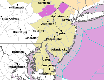
...LIGHT FREEZING RAIN TO IMPACT PARTS OF THE POCONOS AND
NORTHERN NEW JERSEY LATE TONIGHT THROUGH THURSDAY MORNING...

NJZ001-PAZ054-055-271000-
/O.NEW.KPHI.ZR.Y.0003.161027T0600Z-161027T1500Z/
SUSSEX-CARBON-MONROE-
INCLUDING THE CITIES OF...NEWTON...JIM THORPE...STROUDSBURG
329 PM EDT WED OCT 26 2016

...FREEZING RAIN ADVISORY IN EFFECT FROM 2 AM TO 11 AM EDT
THURSDAY...

THE NATIONAL WEATHER SERVICE IN MOUNT HOLLY HAS ISSUED A FREEZING
RAIN ADVISORY...WHICH IS IN EFFECT FROM 2 AM TO 11 AM EDT
THURSDAY.

* LOCATIONS...CARBON AND MONROE COUNTIES IN PENNSYLVANIA AND
  SUSSEX COUNTY IN NEW JERSEY.

* HAZARD TYPES...FREEZING RAIN.

* ICE ACCUMULATIONS...AROUND A TRACE TO A FEW HUNDREDTHS OF AN
  INCH.

* TIMING...LIGHT FREEZING RAIN WILL DEVELOP IN THE LATE NIGHT
  HOURS TONIGHT AND WILL CONTINUE THROUGH THURSDAY MORNING.

* IMPACTS...TRAVEL WILL BE TREACHEROUS AS ROADS AND WALKWAYS WILL
  BE SLIPPERY. BE SURE TO USE CAUTION AND LEAVE PLENTY OF TIME FOR
  TRAVEL IN THE MORNING.

* WINDS...EAST 5 TO 10 MPH.

* TEMPERATURES...IN THE LOW 30S.

PRECAUTIONARY/PREPAREDNESS ACTIONS...

A FREEZING RAIN ADVISORY MEANS THAT PERIODS OF FREEZING RAIN OR
FREEZING DRIZZLE WILL CAUSE TRAVEL DIFFICULTIES. BE PREPARED FOR
SLIPPERY ROADS. SLOW DOWN AND USE CAUTION WHILE DRIVING.

Satellite and radar showing clouds moving east from a storm system moving across the Midwest. We are also beginning to see the first radar echos move into Western Pennsylvania and Western NY.

Nothing of consequence will get here until late tonight or around daybreak Thursday when temperatures will be below 32 in the advisory area. Clouds will increase overnight. Precipitation changes to rain everywhere by midday in the advisory area.
MANY THANKS TO TROPICAL TIDBITS FOR THE WONDERFUL USE OF THE MAPS
SNOW REMOVAL COMPANIES FOR YOUR WINTER NEEDS
LONG ISLAND ROCKLAND COUNTY Connecticut

![]()

WINTER WEATHER OUTLOOK VIDEOS
In case you missed them I’ve been previewing the upcoming winter in a series of posts and videos. Here are the first 2. More will be coming along. Links to the latest posts are below.
NEW JERSEY
LONG ISLAND AND NEARBY
WINTER 2016-2017 PART 3 NEW JERSEY
WINTER 2016-2017 PART 1 OCEAN WATER TEMPERATURES
WINTER 2016-2017 PART 2 ARCTIC SEA ICE AND SIBERIAN SNOW COVER
FiOS1 News Weather Forecast For Long Island
FiOS1 News Weather Forecast For New Jersey
FiOS1 News Weather Forecast For Hudson Valley
NATIONAL WEATHER SERVICE SNOW FORECASTS
LATEST JOESTRADAMUS ON THE LONG RANGE

Weather App

Don’t be without Meteorologist Joe Cioffi’s weather app. It is really a meteorologist app because you get my forecasts and my analysis and not some automated computer generated forecast based on the GFS model. This is why your app forecast changes every 6 hours. It is model driven with no human input at all. It gives you an icon, a temperature and no insight whatsoever.
It is a complete weather app to suit your forecast needs. All the weather information you need is right on your phone. Android or I-phone, use it to keep track of all the latest weather information and forecasts. This weather app is also free of advertising so you don’t have to worry about security issues with your device. An accurate forecast and no worries that your device is being compromised.
Use it in conjunction with my website and my facebook and twitter and you have complete weather coverage of all the latest weather and the long range outlook. The website has been redone and upgraded. Its easy to use and everything is archived so you can see how well Joe does or doesn’t do when it comes to forecasts and outlooks.
Just click on the google play button or the apple store button on the sidebar for my app which is on My Weather Concierge. Download the app for free. Subscribe to my forecasts on an ad free environment for just 99 cents a month.
Get my forecasts in the palm of your hand for less than the cost of a cup of Joe!


