
Freezes Weekend Snow Forecast

MENTION JOE CIOFFI AND GET A 5% DISCOUNT
FREEZE WATCH CENRAL NEW JERSEY SOUTHWARD
WET SNOW SATURDAY TO LEAVE A COATING TO A COUPLE
VERY COLD TEMPERATURES SUNDAY
Aside from the threat of wet snow this weekend we also have the risk of a freeze in areas where the growing season has gotten underway. Freeze Watches are up from Central New Jersey southward for tonight into Saturday morning. This cold air sets up the snow for Saturday. But for today we look to have no worse than partly sunny skies with highs in the upper 40s to lower 50s. There could be a passing shower or two however they should be brief and light in nature. And skies will be clear tonight with lows in the upper 20s to mid 30s as cold air continues to come down from the north.
JOE’S SNOWFALL FORECAST
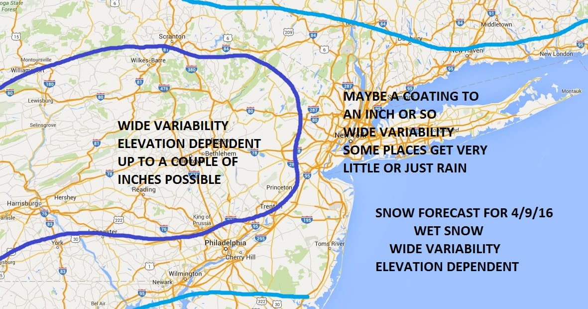
Here is my snowfall forecast map for Saturday. Wet snow and rain begins during the morning hours in western areas of New Jersey and Eastern Pennsylvania and moves to eastern areas of Long Island and New Jersey during the afternoon and evening. There will be wide variability from place to place. Some places will see wet snow coming down and others nearby could see rain. Some areas will elevation could see a couple of inches on the grass while in a nearby valley there will be a coating. These upper air systems in the spring are so difficult to figure. My main take away from this is that since there is no real development of any kind of coastal low, the area of precipitation should not be anything excessive. And since the bulk falls during the day, it keeps roads wet.
Models did trend a little north overnight with the precipitation shield so I want to keep an eye on this just in case. Upper lows can produce unexpected surprises sometimes in localized areas and I want to be open to that possibility. Temperatures will be in the 30s while it is precipitation and once it ends, lows Sunday morning will be in the 20s. Snow should be overwith by early evening western areas and by midnight eastern areas.
Sunday will be dry and cold with sunshine and highs just into the 40s.
FiOS1 News Weather Forecast For Long Island
FiOS1 News Weather Forecast For New Jersey
FiOS1 News Weather Forecast For Hudson Valley
NATIONAL WEATHER SERVICE SNOW FORECASTS
LATEST JOESTRADAMUS ON THE LONG RANGE

NOMINATED FOR AN APPY AWARD FOR BEST WEATHER APP!!
Weather App

Don’t be without Meteorologist Joe Cioffi’s weather app. It is really a meteorologist app because you get my forecasts and my analysis and not some automated computer generated forecast based on the GFS model. This is why your app forecast changes every 6 hours. It is model driven with no human input at all. It gives you an icon, a temperature and no insight whatsoever.
It is a complete weather app to suit your forecast needs. All the weather information you need is right on your phone. Android or I-phone, use it to keep track of all the latest weather information and forecasts. This weather app is also free of advertising so you don’t have to worry about security issues with your device. An accurate forecast and no worries that your device is being compromised.
Use it in conjunction with my website and my facebook and twitter and you have complete weather coverage of all the latest weather and the long range outlook. The website has been redone and upgraded. Its easy to use and everything is archived so you can see how well Joe does or doesn’t do when it comes to forecasts and outlooks.
Just click on the google play button or the apple store button on the sidebar for my app which is on My Weather Concierge. Download the app for free. Subscribe to my forecasts on an ad free environment for just 99 cents a month.
Get my forecasts in the palm of your hand for less than the cost of a cup of Joe!
![]()

