Freeze Warning New Jersey Hudson Valley Eastern Pennsylvania
Freeze Warning New Jersey Hudson Valley Eastern Pennsylvania

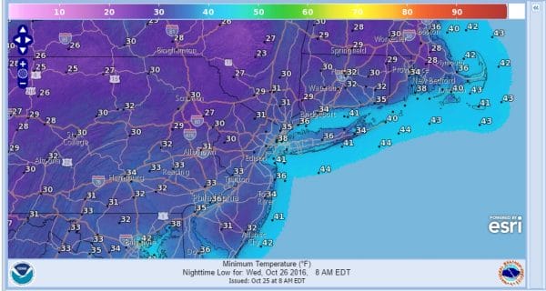
Freeze warnings are posted for much of the area tonight as we will in the core of the coldest air with clear skies and light winds. Most lows tonight will be under 32 creating the first freeze conditions in counties that missed out on the last 2. This will bring 32 degree temperatures to all but the immediate coast. Areas not under a freeze warning north and west have already had their growing season ending freeze. It’s just the first one that warnings are issued for.
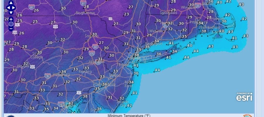
FREEZE WARNING WEDNESDAY MORNING FORECAST LOWS
Satellite loop this morning shows us in clear skies near the coast but there are still a few clouds to the north and northwest but they aren’t going to cause any issues. Highs today will be in the upper 40s to lower 50s which is almost 10 degrees cooler than average for this time of year. Skies will be clear tonight with lows in the mid 20s to near 30 inland and low to mid 30s everywhere else


Wednesday we should see sunshine for a good part of the day before clouds increase later in the afternoon from west to east. Highs will just be in the upper 40s to low 50s again. Then low pressure moves across Indiana and Ohio and heads toward Western NY. If precipitation gets in here fast enough it will start as sleet or wet snow. That will definitely be the case in Northeastern Pennsylvania, Northwest New Jersey north of RT 80 and West of 287..this is especially the case in higher elevations. For the Hudson Valley north of RT 84 especially as you gain elevation and certainly the case as you reach Route 84 and points north and west. How fast precipitation arrives will be important because after mid morning the atmosphere warms up in a hurry.
SNOWFALL FORECAST FOR THURSDAY
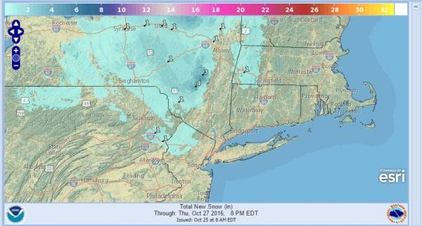
This is an early snowfall forecast map from the National Weather Service digital database. We will be updating this later today as new weather models arrive.
MANY THANKS TO TROPICAL TIDBITS FOR THE WONDERFUL USE OF THE MAPS
SNOW REMOVAL COMPANIES FOR YOUR WINTER NEEDS
LONG ISLAND ROCKLAND COUNTY Connecticut

![]()

WINTER WEATHER OUTLOOK VIDEOS
In case you missed them I’ve been previewing the upcoming winter in a series of posts and videos. Here are the first 2. More will be coming along. Links to the latest posts are below.
NEW JERSEY
LONG ISLAND AND NEARBY
WINTER 2016-2017 PART 3 NEW JERSEY
WINTER 2016-2017 PART 1 OCEAN WATER TEMPERATURES
WINTER 2016-2017 PART 2 ARCTIC SEA ICE AND SIBERIAN SNOW COVER
FiOS1 News Weather Forecast For Long Island
FiOS1 News Weather Forecast For New Jersey
FiOS1 News Weather Forecast For Hudson Valley
NATIONAL WEATHER SERVICE SNOW FORECASTS
LATEST JOESTRADAMUS ON THE LONG RANGE

Weather App

Don’t be without Meteorologist Joe Cioffi’s weather app. It is really a meteorologist app because you get my forecasts and my analysis and not some automated computer generated forecast based on the GFS model. This is why your app forecast changes every 6 hours. It is model driven with no human input at all. It gives you an icon, a temperature and no insight whatsoever.
It is a complete weather app to suit your forecast needs. All the weather information you need is right on your phone. Android or I-phone, use it to keep track of all the latest weather information and forecasts. This weather app is also free of advertising so you don’t have to worry about security issues with your device. An accurate forecast and no worries that your device is being compromised.
Use it in conjunction with my website and my facebook and twitter and you have complete weather coverage of all the latest weather and the long range outlook. The website has been redone and upgraded. Its easy to use and everything is archived so you can see how well Joe does or doesn’t do when it comes to forecasts and outlooks.
Just click on the google play button or the apple store button on the sidebar for my app which is on My Weather Concierge. Download the app for free. Subscribe to my forecasts on an ad free environment for just 99 cents a month.
Get my forecasts in the palm of your hand for less than the cost of a cup of Joe!


