Freeze Possible This Week
CHILLY BUT DRY SUNDAY
SHOWER CHANCE LATE TONIGHT
SECOND COLD SHOT INTO MIDWEEK FREEZE POSSIBLE
Our storm system this morning is still impressive looking as it sits in Northern Maine and is still producing gusty winds this morning but we have dry air in and we will enjoy sunshine today with highs in the upper 50s to lower 60s.
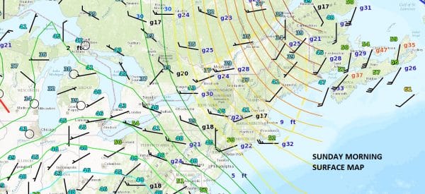
Moving into the Western Great Lakes is an upper air disturbance which is sliding southeastward. This marks a secondary surge of colder air that will arrive Monday morning with a few showers ahead of it late tonight into Monday morning. Then that second shot of cold air takes over into Wednesday.


Radars are quiet today and should remain so all day today and into this evening.
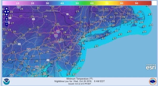
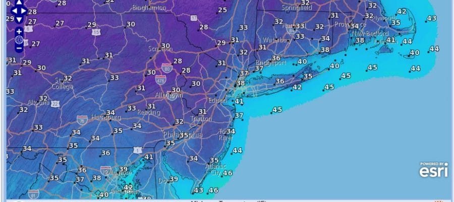
This shot of cold air will produce 2 cold nights. Tuesday morning and Wednesday morning will be cold and I think Wednesday morning we have the stronger chance for an overnight freeze.
Longer term the pattern is going to go rather blocky which we will address in a JOESTRADAMUS long range post later today.
MANY THANKS TO TROPICAL TIDBITS FOR THE WONDERFUL USE OF THE MAPS
SNOW REMOVAL COMPANIES FOR YOUR WINTER NEEDS
LONG ISLAND ROCKLAND COUNTY Connecticut

![]()

WINTER WEATHER OUTLOOK VIDEOS
In case you missed them I’ve been previewing the upcoming winter in a series of posts and videos. Here are the first 2. More will be coming along. Links to the latest posts are below.
NEW JERSEY
LONG ISLAND AND NEARBY
WINTER 2016-2017 PART 3 NEW JERSEY
WINTER 2016-2017 PART 1 OCEAN WATER TEMPERATURES
WINTER 2016-2017 PART 2 ARCTIC SEA ICE AND SIBERIAN SNOW COVER
FiOS1 News Weather Forecast For Long Island
FiOS1 News Weather Forecast For New Jersey
FiOS1 News Weather Forecast For Hudson Valley
NATIONAL WEATHER SERVICE SNOW FORECASTS
LATEST JOESTRADAMUS ON THE LONG RANGE

Weather App

Don’t be without Meteorologist Joe Cioffi’s weather app. It is really a meteorologist app because you get my forecasts and my analysis and not some automated computer generated forecast based on the GFS model. This is why your app forecast changes every 6 hours. It is model driven with no human input at all. It gives you an icon, a temperature and no insight whatsoever.
It is a complete weather app to suit your forecast needs. All the weather information you need is right on your phone. Android or I-phone, use it to keep track of all the latest weather information and forecasts. This weather app is also free of advertising so you don’t have to worry about security issues with your device. An accurate forecast and no worries that your device is being compromised.
Use it in conjunction with my website and my facebook and twitter and you have complete weather coverage of all the latest weather and the long range outlook. The website has been redone and upgraded. Its easy to use and everything is archived so you can see how well Joe does or doesn’t do when it comes to forecasts and outlooks.
Just click on the google play button or the apple store button on the sidebar for my app which is on My Weather Concierge. Download the app for free. Subscribe to my forecasts on an ad free environment for just 99 cents a month.
Get my forecasts in the palm of your hand for less than the cost of a cup of Joe!


