Winter 2016-2017 Preview New York City
Winter 2016-2017 Preview New York City
We continue our preview of Winter 2016-2017 by looking at New York City which sits a rather funny and challenging forecast place geographically. It is one of those spots that is often too far west to catch deepening storms offshore that impact Long Island. It is far enough south where the ocean can warm things up and change things to rain while inland spots snow for much longer or never change to rain at all. It occasionally is too far north for systems that pass to the south and effect southern areas in New Jersey though this option does not happen as often.

You can see on the seasonal snowfall map averages that NYC is cut in half with 20 to 25 inches on the southern flank and 25 to 30″ on the northern half. Frankly I think these numbers are understated by 5 inches or so and I would probably favor the numbers on the high end of the range except right along the immediate coasts of Brooklyn and Queens.
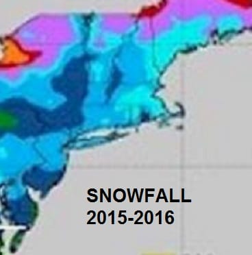
Last year’s snowfall totals were totally dominated by the Blizzard of 2016 which produced the greatest 24 hour snowfall on record for NYC and it accounted for over 90 percent of the winter’s snowfall. There were several events last year that gave Long Island another 10-20 inches of additional snow that NYC missed out on.
JOESTRADAMUS OBSERVATIONS GOING FORWARD
If we look back at the winter of 2013-2014 and some other winters that began early, the warmer fall pattern seem to flip on a dime. I’m thinking that this might be one of those situations and there are some signs that the pattern is going to do this sometime in mid November. Now what it flips to remains to be seen. Until then, the ridge in the east that just won’t go away, might try to flex its muscle one more time during the first week of November. The persistence of this ridge should be distressing to winter weather lovers and needs to go away. However there are some positives that are out there pointing to a colder than normal winter in terms of temperatures.
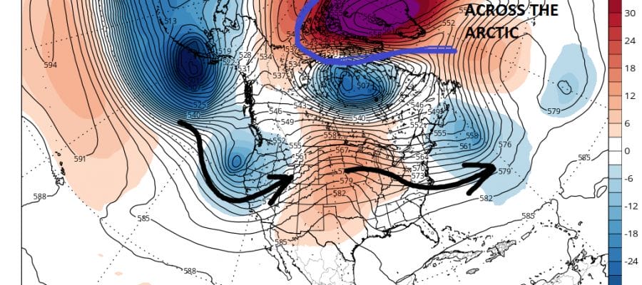
WINTER 2016-2017 WARMING IN ARCTIC REGIONS
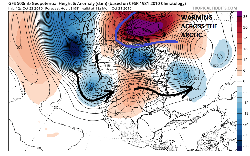
There has been strong indications of a large warming event to occur in the Arctic regions. Such a warmer would signal a gradual displacement of cold air southward into North America for the longer term. Also the polar vortex in the stratosphere (way up) is in a relatively weakened state compared to last year. This also would favor a colder pattern in the east.
WINTER 2016-2017 DROUGHT PATTERN COULD IMPACT SNOWFALL
The drought we are in is no secret and there is nothing that says we can’t have a cold dry winter with below normal snowfall. The persistent dry pattern is a concern and needs to gradually break down. Snow lovers know that all the cold air in the world won’t matter to them if there are no storms, minor or major, there will be below normal snowfall. Right now there is nothing that suggests that the dry pattern is about to change, though it is possible we could see that flip on a dime as well.
WINTER 2016-2017 BLOCKING PATTERN
Blocking is probably an overstated necessity in regards to snowfall. The North Atlantic Oscillation which basically measures the strength (or lack there of) of blocking (often called the Greenland Block) seems to be active for the first time in the last 4 years. Even in the snow winters of 2013-2014 and 2014-2015 blocking was not evident during any of the snow events. Even the Blizzard of 2016 came with only a minimal amount of blocking in the atmosphere. The indexes that measure blocking
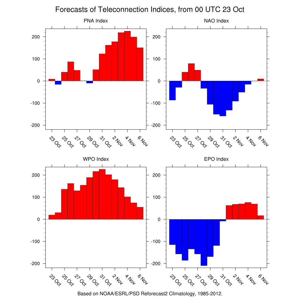
The index which right now that does not favor cold air in the short term is the EPO index which goes positive in early November. A postiive Eastern Pacific Oscillation (like the North Atlantic Oscillation only in the Pacific) does not favor cold air in the East, though a positive Pacific North America index does.
Now that I’ve confused you all let me just summarize this by saying that I am expecting a pattern flip for mid November to one that favors a colder than average regime for the second half of the month. Now whether that pattern flip comes with a change in the drought pattern remains to be seen. On that particular angle of the equation I am quite unsure of.
WINTER 2016-2017 SIBERIAN SNOW COVER GROWTH


Siberian snow cover continues to increase at a very robust rate after stalling out mid-month. The rate of growth is what matters in the areas between the 2 black lines above. 2014-2015 is number 1 on the graph. This October we are right behind that particular winter. What the theory holds (and it doesn’t always work) is that a fast rate of growth of snow cover in Siberia south of 60 degrees north is a predictor of a cold winter in the Eastern US. It did not work last year because of the super strength of El Nino. We do not have that condition this year so this may be a good test of this theory as we have a fast growth rate with no El Nino to deal with. Also a factor in the fast rate of growth is the state of Arctic Sea Ice which is off a near record low this summer and has only been coming back very slowly.
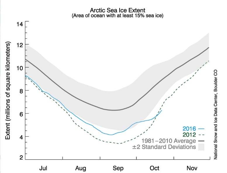
An ice free Arctic Ocean is a great moisture source for Siberian snow cover growth and it remains as low or lower than the record low year of 2012.
Where do we go from here with all of this? Well we need to wait a little while longer as JOESTRADAMUS wants to see the final numbers on Siberian snow cover growth among other things before making his final prediction for the Winter 2016-2017. It appears that the pattern at the moment would suggest a colder than normal winter though I’m not sure it necessarily means a snowier than normal winter. Right now the plan is to do the final forecast in 2 weeks on November 6th at 8:00pm Facebook time with a live broadcast.
MANY THANKS TO TROPICAL TIDBITS FOR THE WONDERFUL USE OF THE MAPS
SNOW REMOVAL COMPANIES FOR YOUR WINTER NEEDS
LONG ISLAND ROCKLAND COUNTY Connecticut

![]()

WINTER 2016-2017 PART 1 OCEAN WATER TEMPERATURES
WINTER 2016-2017 PART 2 ARCTIC SEA ICE AND SIBERIAN SNOW COVER
FiOS1 News Weather Forecast For Long Island
FiOS1 News Weather Forecast For New Jersey
FiOS1 News Weather Forecast For Hudson Valley
NATIONAL WEATHER SERVICE SNOW FORECASTS
LATEST JOESTRADAMUS ON THE LONG RANGE
Weather App

Don’t be without Meteorologist Joe Cioffi’s weather app. It is really a meteorologist app because you get my forecasts and my analysis and not some automated computer generated forecast based on the GFS model. This is why your app forecast changes every 6 hours. It is model driven with no human input at all. It gives you an icon, a temperature and no insight whatsoever.
It is a complete weather app to suit your forecast needs. All the weather information you need is right on your phone. Android or I-phone, use it to keep track of all the latest weather information and forecasts. This weather app is also free of advertising so you don’t have to worry about security issues with your device. An accurate forecast and no worries that your device is being compromised.
Use it in conjunction with my website and my facebook and twitter and you have complete weather coverage of all the latest weather and the long range outlook. The website has been redone and upgraded. Its easy to use and everything is archived so you can see how well Joe does or doesn’t do when it comes to forecasts and outlooks.
Just click on the google play button or the apple store button on the sidebar for my app which is on My Weather Concierge. Download the app for free. Subscribe to my forecasts on an ad free environment for just 99 cents a month.
Get my forecasts in the palm of your hand for less than the cost of a cup of Joe!
![]()

