Flooding Wind Rain Arrives During Early Morning Hours
Flooding Wind Rain Arrives During Early Morning Hours
It appears that there will be 2 main surges of heavy rains on Thursday. The first will come during the morning commute and moves up through New Jersey and into Long Island around 4am or so as per the HRRR model
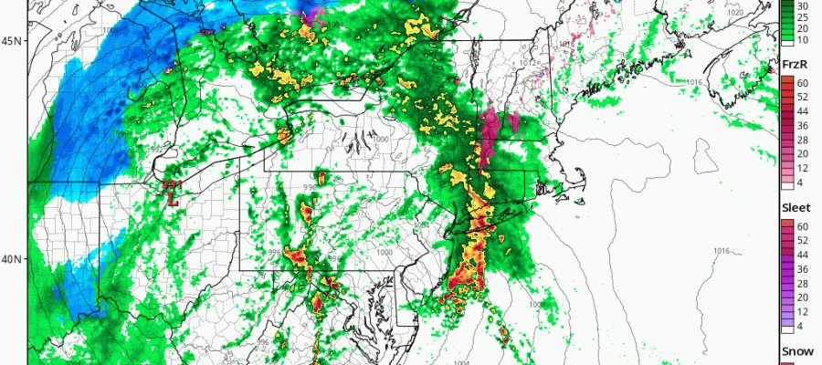
FLOODING RAIN WIND HRRR RAIN THURSDAY MORNING
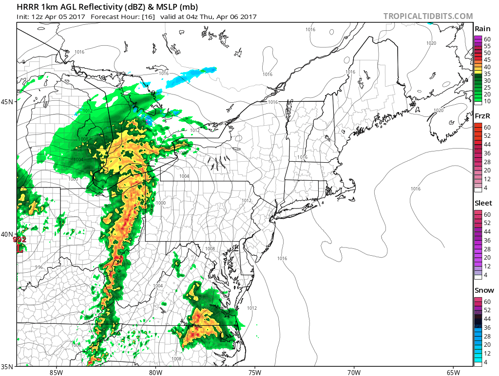
This shot of rain should produce a third to two thirds of an inch of rain as it moves through. Then there will be a short break before the next area of rain develops during the morning over New Jersey and moves northward as per the NAM model.
FLOODING RAIN WIND NAM MODEL THURSDAY 9AM-3PM

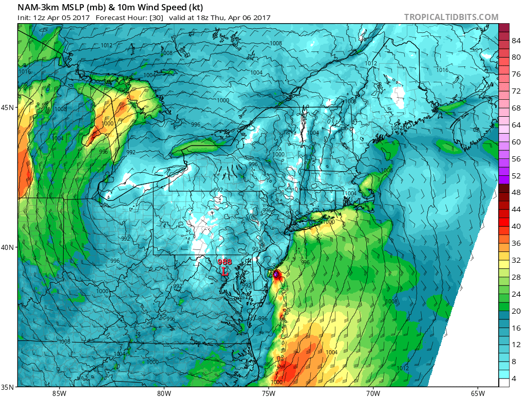
The NAM model above is very aggressive with the thunderstorms that develop and produce 2 to 4 inches of rain for much of the area which is double what some of the other models are showing. Given that we have seen relative out performance of reality lately I would certainly not rule out the possibility that rainfall amounts could be higher than the 1 to 2 inches forecast. The saturated ground would mean local small stream, urban, and river flooding is likely. Wind may also be an issue for coastal areas with strong gusty southeast winds as intense low pressure finds its way into Central Pennsylvania.
NAM WIND FORECAST 2PM THURSDAY
As far as weather conditions are concerned this evening we are seeing clouds to the north and overhead and some dry air ahead of the storm to the west and the thunderstorms developing to the south. Weather conditions should be tranquil through at least midnight tonight with no issues.
SATELLITE LOOP

REGIONAL RADAR

LOCAL RADAR NEW YORK CITY

LOCAL RADAR PHILADELPHIA


Rains will be ending from south to north from late afternoon into the evening. There is the possibility of severe weather over New Jersey as per the Storm Prediction Center severe weather risk map and given the dynamics that are present with the strong upper air storm approaching, I would not be surprised to see some severe thunderstorms in the mix from Central New Jersey southward. Friday we will see leftover clouds and leftover passing showers with temperatures in the 50s. The weekend is dry. Saturday will be breezy and a bit chilly with some sunshine and highs in the 50s. A big warm up gets underway on Sunday with sunshine and highs in the 60s. Monday into Wednesday of next week we will see sunshine and temperatures in the 70s in many areas.
For more on the warm up next week check JOESTRADAMUS’s latest post on the long range.
 GET JOE A CIGAR IF YOU LIKE

LANDSCAPE COMPANIES FOR YOUR NEEDS
LONG ISLAND ROCKLAND COUNTY Connecticut

![]()

ROCKLAND COUNTY TRI STATE SNOW REMOVAL JOHNSTOWN PA


FiOS1 News Weather Forecast For Long Island
FiOS1 News Weather Forecast For New Jersey
FiOS1 News Weather Forecast For Hudson Valley
NATIONAL WEATHER SERVICE SNOW FORECASTS
LATEST JOESTRADAMUS ON THE LONG RANGE
Weather App

Don’t be without Meteorologist Joe Cioffi’s weather app. It is really a meteorologist app because you get my forecasts and my analysis and not some automated computer generated forecast based on the GFS model. This is why your app forecast changes every 6 hours. It is model driven with no human input at all. It gives you an icon, a temperature and no insight whatsoever.
It is a complete weather app to suit your forecast needs. All the weather information you need is right on your phone. Android or I-phone, use it to keep track of all the latest weather information and forecasts. This weather app is also free of advertising so you don’t have to worry about security issues with your device. An accurate forecast and no worries that your device is being compromised.
Use it in conjunction with my website and my facebook and twitter and you have complete weather coverage of all the latest weather and the long range outlook. The website has been redone and upgraded. Its easy to use and everything is archived so you can see how well Joe does or doesn’t do when it comes to forecasts and outlooks.
Just click on the google play button or the apple store button on the sidebar for my app which is on My Weather Concierge. Download the app for free. Subscribe to my forecasts on an ad free environment for just 99 cents a month.
Get my forecasts in the palm of your hand for less than the cost of a cup of Joe!


