Flood Watch As Heavy Downpours Move Northward

Flood Watch As Heavy Downpours Move Northward
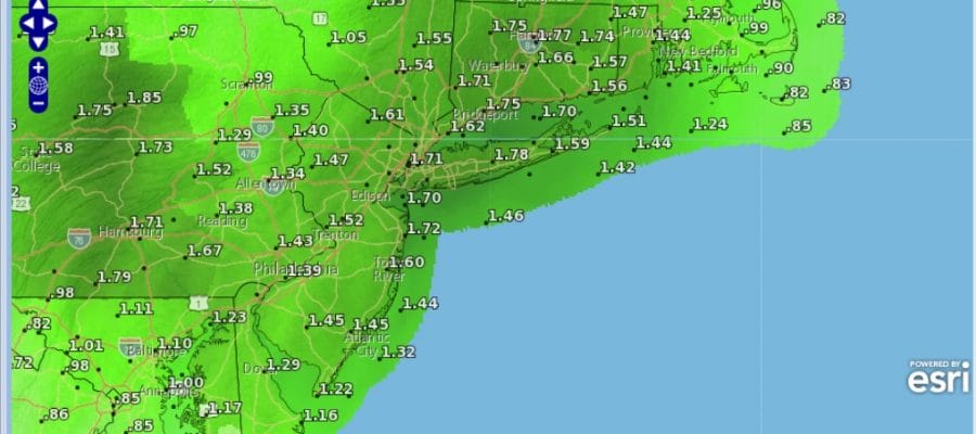
Give yourself an extra 20 to 30 minutes in your commute this morning as heavy downpours are developing on the radars across New Jersey and spreading northward into the Hudson Valley, New York City and Long Island. We see the rainfall forecast above showing a generous 1 to 2 inch rainfall across the entire area. Normally this would be manageable except that the ground is saturated from 3 rain events of an inch or more in the last 8 days and this will make 4. Flooding will come faster thanks to a saturated ground and rivers and streams are running on the high side from those rains and the hefty snow melt of 2 weeks ago. Be cautions in the usual suspect areas this morning while travelling.
SATELLITE LOOP

REGIONAL RADAR

LOCAL RADAR NEW YORK CITY

LOCAL RADAR PHILADELPHIA


Radars overnight were slowly loading up and as the commute gets underway there will be downpours across New Jersey moving northeastward and gradually covering the entire area through Southeast NY and Southern New England between 5 and 8am. The first surge of rain and downpours will play through but there will be two others later today which may at least put the start of the evening commute at risk for problems.
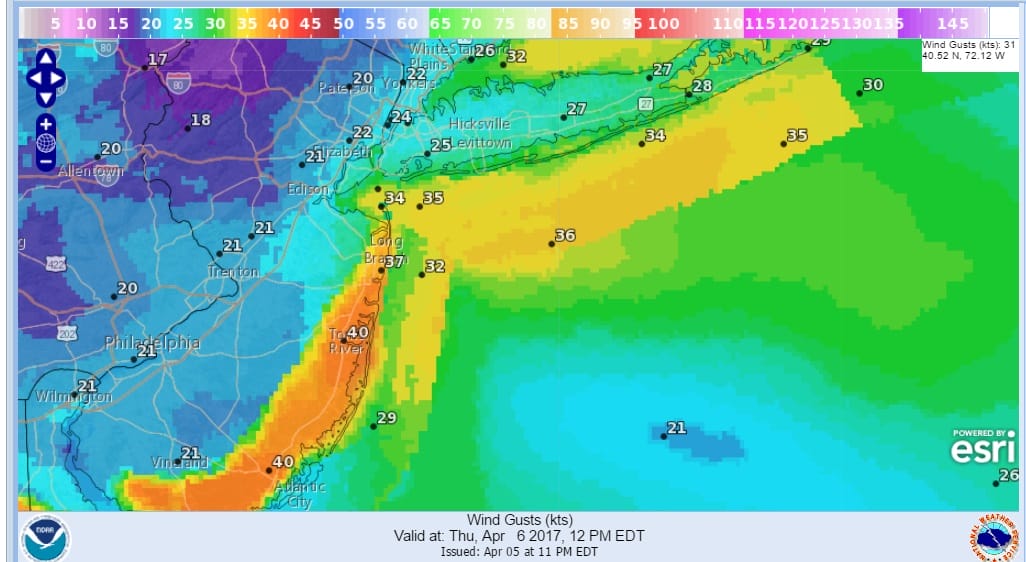
Watch for possible strong thunderstorms in the mix especially in Central and South Jersey. Along the coast gusty southeast winds to 30 to 40 mph will be common. Wind Advisories are posted for the New Jersey shore from Sandy Hook to Cape May. Coastal flood advisory is posted in and around New York Harbor including the New Jersey counties along with the Long Island South Shore. Coastal flooding should be minor in nature thanks to no full or new moon.
Friday we will see some slight improvement though clouds and passing showers will be around with temperatures in the 50s. Some sunshine breezy and dry conditions will arrive Saturday with highs in the 50s. Then a big warm up begins Sunday with temperatures in the 60s followed by sunshine and 70s for Monday and Tuesday.
 GET JOE A CIGAR IF YOU LIKE

LANDSCAPE COMPANIES FOR YOUR NEEDS
LONG ISLAND ROCKLAND COUNTY Connecticut

![]()

ROCKLAND COUNTY TRI STATE SNOW REMOVAL JOHNSTOWN PA


FiOS1 News Weather Forecast For Long Island
FiOS1 News Weather Forecast For New Jersey
FiOS1 News Weather Forecast For Hudson Valley
NATIONAL WEATHER SERVICE SNOW FORECASTS
LATEST JOESTRADAMUS ON THE LONG RANGE
Weather App

Don’t be without Meteorologist Joe Cioffi’s weather app. It is really a meteorologist app because you get my forecasts and my analysis and not some automated computer generated forecast based on the GFS model. This is why your app forecast changes every 6 hours. It is model driven with no human input at all. It gives you an icon, a temperature and no insight whatsoever.
It is a complete weather app to suit your forecast needs. All the weather information you need is right on your phone. Android or I-phone, use it to keep track of all the latest weather information and forecasts. This weather app is also free of advertising so you don’t have to worry about security issues with your device. An accurate forecast and no worries that your device is being compromised.
Use it in conjunction with my website and my facebook and twitter and you have complete weather coverage of all the latest weather and the long range outlook. The website has been redone and upgraded. Its easy to use and everything is archived so you can see how well Joe does or doesn’t do when it comes to forecasts and outlooks.
Just click on the google play button or the apple store button on the sidebar for my app which is on My Weather Concierge. Download the app for free. Subscribe to my forecasts on an ad free environment for just 99 cents a month.
Get my forecasts in the palm of your hand for less than the cost of a cup of Joe!


