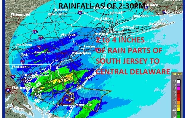
FLOODING RAINS SOUTH JERSEY 2 TO 4 INCHES SO FAR
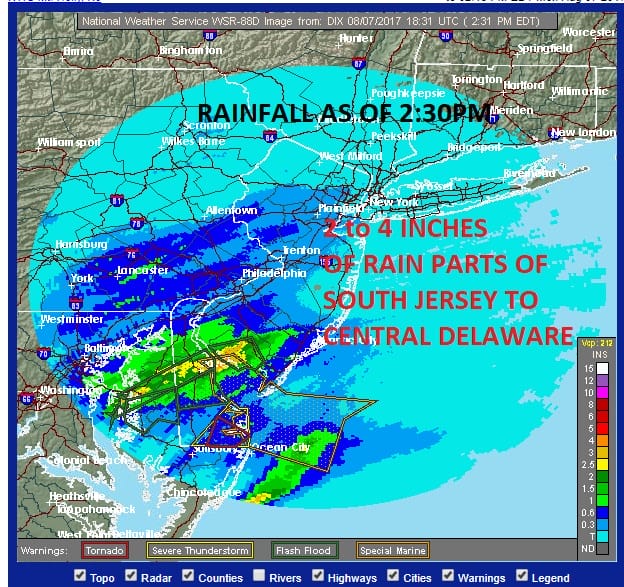
FLOODING RAINS SOUTH JERSEY 2 TO 4 INCHES SO FAR
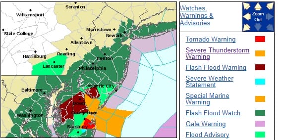
So far the rainfall in Southern New Jersey has been substantial with some areas already seeing 2 to 4 inches of rain. Flash Flood Warnings are posted for the Southwestern New Jersey counties through this evening and the rains continue though the western edge of the rain is making progress eastward based on the latest radars.
To tjhe north steady rain is now moving in but it appears tht the heavy rains will stay south of Route 195 where 1 to 2 inches on average will fall with of course some places putting down some hefty amounts in heavier downpours. North of Route 195 in Northern New Jersey northeast to Southern New England including Long Island will see amounts generally between 1/2 inch and 1 inch. The further north you go the less you will see.
REGIONAL RADAR

LOCAL RADAR NEW YORK CITY

LOCAL RADAR PHILADELPHIA


The rains will begin tapering off from southwest to northeast this evening and tonight. Sunshine returns Tuesday and it looks to stay dry into at least Thursday.
As for Tropical Storm Franklin satellite loops show it strengthening and an eye has developed. Franklin may become a hurricane this evening as it moves to the west northwest toward the Yucatan Peninsula.

…FRANKLIN EXPECTED TO STRENGTHEN SOME MORE BEFORE LANDFALL…
SUMMARY OF 100 PM CDT…1800 UTC…INFORMATION
———————————————-
LOCATION…18.0N 85.4W
ABOUT 185 MI…300 KM E OF BELIZE CITY
ABOUT 195 MI…310 KM E OF CHETUMAL MEXICO
MAXIMUM SUSTAINED WINDS…60 MPH…95 KM/H
PRESENT MOVEMENT…WNW OR 300 DEGREES AT 13 MPH…20 KM/H
MINIMUM CENTRAL PRESSURE…999 MB…29.50 INCHES
WATCHES AND WARNINGS
——————–
CHANGES WITH THIS ADVISORY:
None.
SUMMARY OF WATCHES AND WARNINGS IN EFFECT:
A Hurricane Watch is in effect for…
* The coast of Mexico from Chetumal to Punta Allen
A Tropical Storm Warning is in effect for…
* Belize City northward to the border of Mexico
* The coast of Mexico from Chetumal to Campeche
A Tropical Storm Watch is in effect for…
* The coast of Mexico from Campeche to Sabancuy
A Hurricane Watch means that hurricane conditions are possible
within the watch area, in this case within the next 24 hours.
A Tropical Storm Warning means that tropical storm conditions are
expected somewhere within the warning area, in this case within
24 hours.
A Tropical Storm Watch means that tropical storm conditions are
possible within the watch area.
Interests elsewhere around the Bay of Campeche should monitor the
progress of this system.
For storm information specific to your area, please monitor
products issued by your national meteorological service.
DISCUSSION AND 48-HOUR OUTLOOK
——————————
At 100 PM CDT (1800 UTC), the center of Tropical Storm Franklin was
located near latitude 18.0 North, longitude 85.4 West. Franklin is
moving toward the west-northwest near 13 mph (20 km/h), and this
general motion is expected to continue over the next 48 hours. On
the forecast track, the center of Franklin will be near the east
coast of the Yucatan peninsula by this evening. Franklin is then
expected to move across the Yucatan Peninsula tonight and on
Tuesday.
Maximum sustained winds are near 60 mph (95 km/h) with higher
gusts. Strengthening is forecast until the center reaches the east
coast of the Yucatan peninsula, and Franklin could be near hurricane
strength by the time landfall occurs this evening or tonight. Some
weakening is likely while the system moves across the Yucatan
Peninsula on Tuesday.
Tropical-storm-force winds extend outward up to 140 miles (220 km)
from the center.
The minimum central pressure reported by an Air Force Hurricane
Hunter aircraft is 999 mb (29.50 inches).
 GET JOE A CIGAR IF YOU LIKE

LANDSCAPE COMPANIES FOR YOUR NEEDS
LONG ISLAND ROCKLAND COUNTY Connecticut

![]()

ROCKLAND COUNTY TRI STATE SNOW REMOVAL JOHNSTOWN PA


FiOS1 News Weather Forecast For Long Island
FiOS1 News Weather Forecast For New Jersey
FiOS1 News Weather Forecast For Hudson Valley
NATIONAL WEATHER SERVICE SNOW FORECASTS
LATEST JOESTRADAMUS ON THE LONG RANGE
Weather App

Don’t be without Meteorologist Joe Cioffi’s weather app. It is really a meteorologist app because you get my forecasts and my analysis and not some automated computer generated forecast based on the GFS model. This is why your app forecast changes every 6 hours. It is model driven with no human input at all. It gives you an icon, a temperature and no insight whatsoever.
It is a complete weather app to suit your forecast needs. All the weather information you need is right on your phone. Android or I-phone, use it to keep track of all the latest weather information and forecasts. This weather app is also free of advertising so you don’t have to worry about security issues with your device. An accurate forecast and no worries that your device is being compromised.
Use it in conjunction with my website and my facebook and twitter and you have complete weather coverage of all the latest weather and the long range outlook. The website has been redone and upgraded. Its easy to use and everything is archived so you can see how well Joe does or doesn’t do when it comes to forecasts and outlooks.
Just click on the google play button or the apple store button on the sidebar for my app which is on My Weather Concierge. Download the app for free. Subscribe to my forecasts on an ad free environment for just 99 cents a month.
Get my forecasts in the palm of your hand for less than the cost of a cup of Joe!