
Flash Flood Watch NE New Jersey Southward NYC Long Island
Flash Flood Watch NE New Jersey Southward NYC Long Island
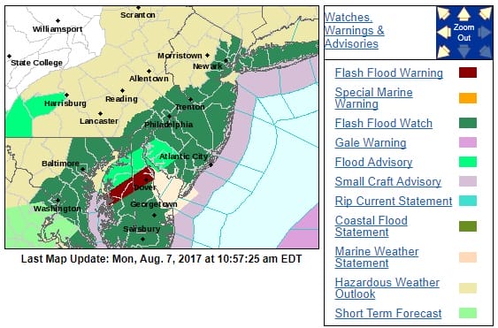
Flash Flood Watch continues this afternoon and has been extended to include Northeast New Jersey, NYC, & Long Island and runs south to Delaware Maryland & Southeastern Pennsylvania. Rain is beginning to move in on the radar as low pressure heads to Virginia and then off the New Jersey coast tonight. Rainfall amounts look to be in the 1 to 2 inch range.

Rainfall amounts will be greatest in Southern New Jersey where the northern fringe of the severe weather in terms of heavy thunderstorms as the severe weather threat sets up south of NYC. North of New York City across Northern New Jersey, the Hudson Valley & Connecticut, rain will be less than an inch and in some cases less than half an inch.
SATELLITE LOOP

REGIONAL RADAR
Heavy rains on the regional radar are revving up to the south and west and this will be moving in this afternoon into tonight so the evening commute is likely to be a wet one. Temperatures are going to be in the 60s to near 70 north and west of the low track while 70s are likely well to the south.

LOCAL RADAR NEW YORK CITY

LOCAL RADAR PHILADELPHIA


Rain will be ending from west to east tonight and weather conditions improve for Tuesday into Thursday with sunshine and temperatures in the upper 70s to lower 80s with lower humidity. The next chance for rain or showers will on Friday and possibly over the weekend. There is no hot weather in sight for at least the next 7 days.
 GET JOE A CIGAR IF YOU LIKE

LANDSCAPE COMPANIES FOR YOUR NEEDS
LONG ISLAND ROCKLAND COUNTY Connecticut

![]()

ROCKLAND COUNTY TRI STATE SNOW REMOVAL JOHNSTOWN PA


FiOS1 News Weather Forecast For Long Island
FiOS1 News Weather Forecast For New Jersey
FiOS1 News Weather Forecast For Hudson Valley
NATIONAL WEATHER SERVICE SNOW FORECASTS
LATEST JOESTRADAMUS ON THE LONG RANGE
Weather App

Don’t be without Meteorologist Joe Cioffi’s weather app. It is really a meteorologist app because you get my forecasts and my analysis and not some automated computer generated forecast based on the GFS model. This is why your app forecast changes every 6 hours. It is model driven with no human input at all. It gives you an icon, a temperature and no insight whatsoever.
It is a complete weather app to suit your forecast needs. All the weather information you need is right on your phone. Android or I-phone, use it to keep track of all the latest weather information and forecasts. This weather app is also free of advertising so you don’t have to worry about security issues with your device. An accurate forecast and no worries that your device is being compromised.
Use it in conjunction with my website and my facebook and twitter and you have complete weather coverage of all the latest weather and the long range outlook. The website has been redone and upgraded. Its easy to use and everything is archived so you can see how well Joe does or doesn’t do when it comes to forecasts and outlooks.
Just click on the google play button or the apple store button on the sidebar for my app which is on My Weather Concierge. Download the app for free. Subscribe to my forecasts on an ad free environment for just 99 cents a month.
Get my forecasts in the palm of your hand for less than the cost of a cup of Joe!


