
Flooding Possible Wednesday

Now that the first round of rain is winding down the second round of rain begins on Wednesday. A major storm is moving into the Ohio Valley. 2 inch plus rains along with some thunderstorms are forecast making flooding possible Wednesday of poor drainage areas. The satellite loop shows an intense twist in the clouds from the system coming out of the Gulf states and making its way into the Ohio Valley. There was severe weather today across Louisiana, Mississippi, and Alabama. Tropical air will be surging up the east coast on Wednesday adding additional moisture fuel.
Flooding Possible Wednesday Satellite & Radar Loops

Local radars right now sow the first round of precipitation moving. Some inland areas are still seeing temperatures below 32 and there is some icing that is occurring in pockets of Northern New Jersey, the Hudson Valley of NY and interior Connecticut. Temperatures should nudge higher overnight and everyone will be above freezing by the time the first round of rains arrive Wednesday morning.


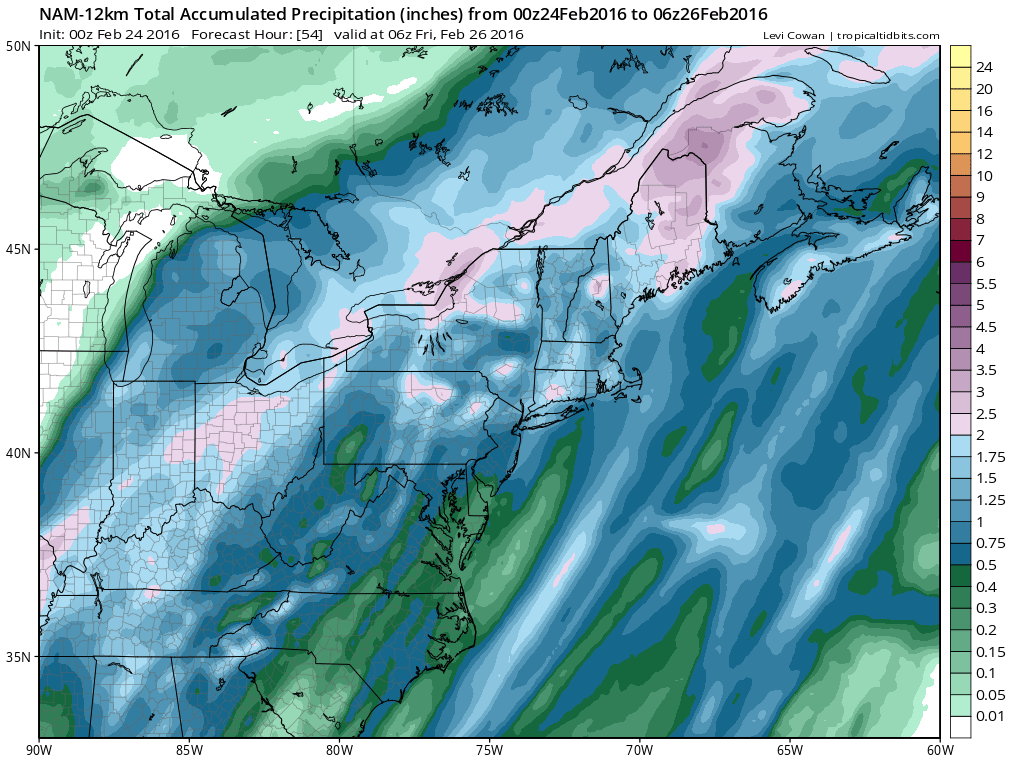
Tonight’s NAM model is probably the least bullish on the rain given the convective nature that it is going to be in. Amounts still should approach 2 inches in places however and other models are more bullish with the rainfall.
Flooding Possible Wednesday NAM Model Rainfall Forecast
Temperatures will rise to the 50s to near 60 by midnight tomorrow night before the cold front moves through in the early morning hours on Thursday. Drier air arrives on Thursday and temperatures will slowly fall off into the 40s by mid or late afternoon and into the 30s Thursday night. Dry weather will be with us for Friday and through the weekend with some sunshine. Temperatures will be chilly Friday and Saturday but warm up again on Sunday.
Two other issues for Wednesday. Gale Warnings are up for the coastal waters. We will also see strong southerly winds Wednesday and Wednesday night which could mean some coastal flooding issues for the south shore of Long Island.
FiOS1 News Weather Forecast For Long Island
FiOS1 News Weather Forecast For New Jersey
FiOS1 News Weather Forecast For Hudson Valley
NATIONAL WEATHER SERVICE SNOW FORECASTS
LATEST JOESTRADAMUS ON THE LONG RANGE
Weather App

Winter is INSANE! With yet another threat for a storm don’t be without Meteorologist Joe Cioffi’s weather app. It is really a meteorologist app because you get my forecasts and my analysis and not some automated computer generated forecast based on the GFS model. This is why your app forecast changes every 6 hours. It is model driven with no human input at all. It gives you an icon, a temperature and no insight whatsoever.
It is a complete weather app to suit your forecast needs. All the weather information you need is right on your phone. Android or I-phone, use it to keep track of all the latest weather information and forecasts. This weather app is also free of advertising so you don’t have to worry about security issues with your device. An accurate forecast and no worries that your device is being compromised.
Use it in conjunction with my website and my facebook and twitter and you have complete weather coverage of all the latest weather and the long range outlook. The website has been redone and upgraded. Its easy to use and everything is archived so you can see how well Joe does or doesn’t do when it comes to forecasts and outlooks.
Just click on the google play button or the apple store button on the sidebar for my app which is on My Weather Concierge. Download the app for free. Subscribe to my forecasts on an ad free environment for just 99 cents a month.
Get my forecasts in the palm of your hand for less than the cost of a cup of Joe!
![]()
![]()