
Flooding Possibility Saturday 1-3 Inches Rain
Flooding Possibility Saturday 1-3 Inches Rain
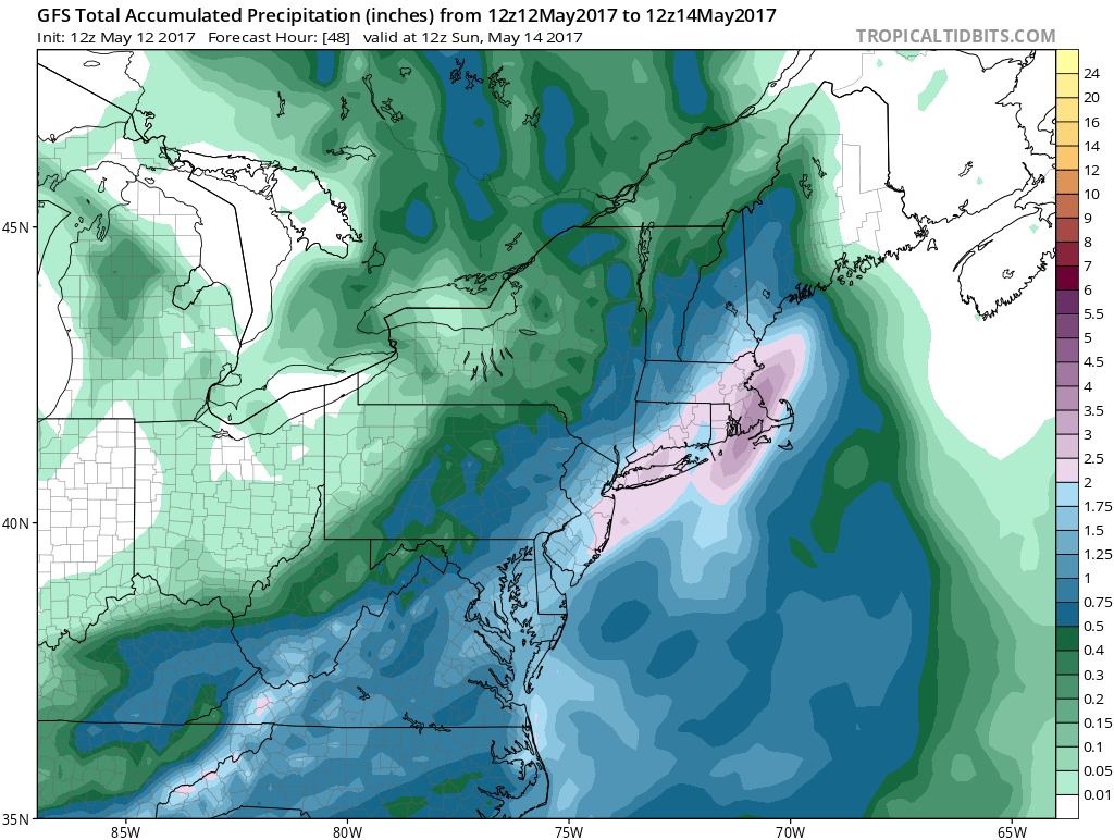
Weather models all have come back to the original idea of a robust rainfall of up to several inches. The GFS model has been holding firm in its track of a coastal low further west and this seems to be where we are going with this.
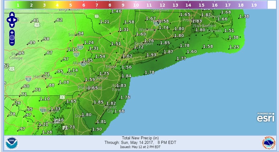
LOCAL FLOODING POSSIBLE GFS RAINFALL FORECAST
We could say this would help ease the drought but as we reported yesterday the drought across the Northeast and Middle Atlantic States is over. Satellite loops this afternoon show that the block is breaking down rapidly. The coastal low that is offshore is beginning to finally move to the east which opens the door for the system now cross the Central Gulf States to begin its move to the northeast. The moisture field is loading up and clouds will be increasing tonight. Rain arrives in New Jersey during the early morning hours before daybreak and then quickly spreads east to the Hudson Valley Southern New England NYC and Long Island during Saturday morning.
SATELLITE LOOP

REGIONAL RADAR

Rain is beginning to build to our south across Virginia and Maryland while the local radar views remain quiet for now but they should start to see activity develop later this evening and of course overnight.
LOCAL RADAR NEW YORK CITY

LOCAL RADAR PHILADELPHIA


The heaviest rain will be Saturday afternoon into Saturday night and this will create some local flooding issues. The rain will being to end from southwest to northeast during Saturday night across New Jersey but they rain will still be there Sunday morning over Southern New England and Long Island before ending during the morning. There will be some improvement across Eastern Pennsylvania and New Jersey with some sunshine developing and a gusty wind while clouds might linger along the coast into Sunday afternoon. Temperatures Saturday will be just into the 50s and winds along the coast will probably reaching gale force. Late Sunday afternoon a few passing showers are possible before it completely clears out Sunday night. Monday will be breezy with some sunshine and highs into the 70s. Much warmer weather is coming later next week as temperatures head for the 80s by as early as Wednesday.
 GET JOE A CIGAR IF YOU LIKE

LANDSCAPE COMPANIES FOR YOUR NEEDS
LONG ISLAND ROCKLAND COUNTY Connecticut

![]()

ROCKLAND COUNTY TRI STATE SNOW REMOVAL JOHNSTOWN PA


FiOS1 News Weather Forecast For Long Island
FiOS1 News Weather Forecast For New Jersey
FiOS1 News Weather Forecast For Hudson Valley
NATIONAL WEATHER SERVICE SNOW FORECASTS
LATEST JOESTRADAMUS ON THE LONG RANGE
Weather App

Don’t be without Meteorologist Joe Cioffi’s weather app. It is really a meteorologist app because you get my forecasts and my analysis and not some automated computer generated forecast based on the GFS model. This is why your app forecast changes every 6 hours. It is model driven with no human input at all. It gives you an icon, a temperature and no insight whatsoever.
It is a complete weather app to suit your forecast needs. All the weather information you need is right on your phone. Android or I-phone, use it to keep track of all the latest weather information and forecasts. This weather app is also free of advertising so you don’t have to worry about security issues with your device. An accurate forecast and no worries that your device is being compromised.
Use it in conjunction with my website and my facebook and twitter and you have complete weather coverage of all the latest weather and the long range outlook. The website has been redone and upgraded. Its easy to use and everything is archived so you can see how well Joe does or doesn’t do when it comes to forecasts and outlooks.
Just click on the google play button or the apple store button on the sidebar for my app which is on My Weather Concierge. Download the app for free. Subscribe to my forecasts on an ad free environment for just 99 cents a month.
Get my forecasts in the palm of your hand for less than the cost of a cup of Joe!


