Flood Watches Southeast NY Southern Central New England Severe Weather Risks

Flood Watches Southeast NY Southern Central New England Severe Weather Risks
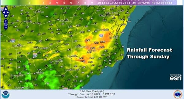
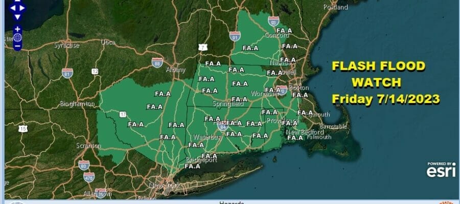
We are entering a very active period for showers and thunderstorms over the next 3 days. Rainfall is going to be an issue and we have flood watches up for Central & Southern New England as well as Southeast NY. Also flood watches have been issued for Southeast Virginia and much of Eastern North Carolina. Those two areas seem to be the center of heavy rain risk through Sunday as several weather systems move through the Eastern US. Rainfall amounts of 2 to 3 inches are likely. In situations like this, due to the convective nature of the rain, local rainfall amounts could double the forecast.
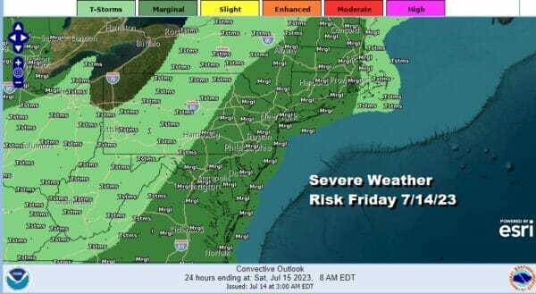
In addition we have severe weather risk along US East Coast with a marginal risk for severe weather from Central New England and Eastern NY south to Long Island, New Jersey, Eastern Pennsylvania continuing further south into Virginia and North Carolina. Isolated severe thunderstorms are possible in this area later today and tonight but the main risk is going to be heavy flooding rain.
SATELLITE WITH LIGHTNING STRIKES

WEATHER RADAR

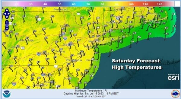
Eastern Pennsylvania to Southern New England should catch a bit of a break Saturday. There could a scattered shower or thunderstorm, and there is always the chance that there might be some flash flooding from any storm, however Saturday will be the better of the two weekend days. highs will be in the mid to upper 80s with high humidity.

A stronger cold front will arrive Sunday and it is likely we will see widespread downpours and thunderstorms during the day Sunday. There is a marginal risk for severe weather Sunday from Delware to the eastern half of NY State into Western New England but the bigger risk again will be flash flooding.

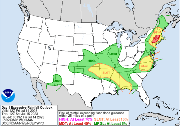
The Weather Prediction Center indicates elevated risk fro for flash flooding from Northern New Jersey to New England Sunday. It also is indicating an area of moderate risk from Connecticut northeastward into Massachusetts, parts of Southern Vermont and into New Hampshire. This cold front will move offshore late Sunday or Sunday evening and that should lead to improvement Monday. Sunday highs will be in the 80s until rains develop and cool temperatures back into the 70s. Humidity levels will remain off the wall into Sunday but should improve slightly Monday.
BE SURE TO DOWNLOAD THE FREE METEOROLOGIST JOE CIOFFI WEATHER APP &
ANGRY BEN’S FREE WEATHER APP “THE ANGRY WEATHERMAN!
MANY THANKS TO TROPICAL TIDBITS FOR THE USE OF MAPS
Please note that with regards to any severe weather, tropical storms, or hurricanes, should a storm be threatening, please consult your local National Weather Service office or your local government officials about what action you should be taking to protect life and property.
(Amazon is an affilate of Meteorologist Joe Cioffi & earns commissions on sales.)


