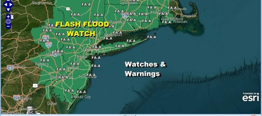
Flash Flood Watch Northern Mid Atlantic to Southeast New England
Heavy Rain Sunday

Flash Flood Watch Northern Mid Atlantic to Southeast New England
Heavy Rain Sunday

Another summer weekend is underway and we can definitely say that Saturday will be the better of the two weekend days. Sunday is going to be a problem. Many areas in the Northeast and Northern Mid Atlantic states have seen a foot of rain in the last 6 days and more rain is coming. Widespread flash flood watches are up from Eastern Pennsylvania and Delaware northeast to NYC & Long Island, Upstate NY, Southern and Central New England.

Once again we are looking at rainfall amounts ranging from 1 to 3 inches however in these summetime set ups some local rainfall amounts could easily be double the forecast depending on whether a thunderstorm sits around long enough or you get “training” which is where thunderststorms roll over the same area over and over. 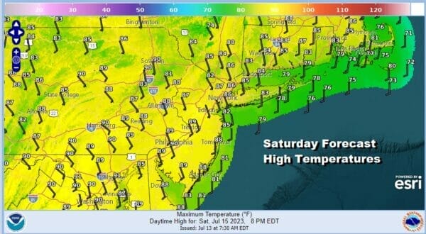
Meanwhile we have today which is a very warm to hot and very humid day ahead with a good deal of sunshine and the chance for a scattered downpour or thunderstorm. Temperatures today will be in the mid 80s to near 90 degrees. Dew points are in the very high 70s making for a miserably uncomfortable day indeed. Satellite and radar loops show us basically between two weather systems and in a good spot today.
SATELLITE WITH LIGHTNING STRIKES

WEATHER RADAR

Weather conditions will begin to deteriorate overnight and into Sunday morning. A cold front is heading east and slowing down. Rain and thunderstorms will develop in the tropical air mass ahead of it and we will see downpours break out probably after midnight and before daybreak.

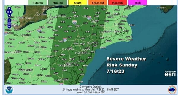
Rain and thunderstorms will last into the afternoon before ending from west to east. The Weather Prediction Center is indicating a moderate risk of excessive rainfall causing flash flooding from Northern New Jersey through much of New England. .

The Storm Prediction Center is also in the mix Sunday with a marginal risk for isolated severe thunderstorms from NY state southward through the Mid Atlantic states and there is the small chance for the odd tornado or two to spin up. While it is raining temperatures will be in the 70s to around 80 degrees.
The front will pass offshore Sunday evening as winds shift to the west. Most but not all the tropical moisture in the atmosphere will have been wrung out and that leaves us with a better day Monday though it will be hot and it will be humid, just not extreme. Highs Monday with sunshine will be in the upper 80s to lower 90s.
BE SURE TO DOWNLOAD THE FREE METEOROLOGIST JOE CIOFFI WEATHER APP &
ANGRY BEN’S FREE WEATHER APP “THE ANGRY WEATHERMAN!
MANY THANKS TO TROPICAL TIDBITS FOR THE USE OF MAPS
Please note that with regards to any severe weather, tropical storms, or hurricanes, should a storm be threatening, please consult your local National Weather Service office or your local government officials about what action you should be taking to protect life and property.
(Amazon is an affilate of Meteorologist Joe Cioffi & earns commissions on sales.)


