Flood Watch Southern New Jersey Southeastern Pennsylvania
Flood Watch Southern New Jersey Southeastern Pennsylvania
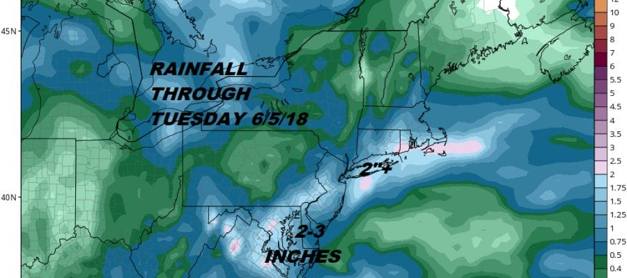
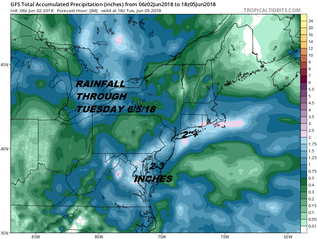
The weekend is underway and today we have a slow moving cold front that is literally inching its way through here. This leaves us in very warm humid conditions with the risk for some downpours or some thunderstorms developing during this afternoon but not everyone sees them. Flood Watches are posted for Southern New Jersey & Southeastern Pennsylvania for at least a few inches of rain from either the downpours we see today or the steady rain that falls Sunday night and Monday. Temperatures today will reach into the 80s in most places.
Keep an eye on the satellite picttures and loops today as we watch dry air developing over Northern New England begin to push southward. It will get here tonight and we will cool off into the 50s as the humidity drops and skies clear from Central & Northern New Jersey north and east. This is going to set up taht area from there to Southern New England and Long Island with sunshine for at least half of Sunday before clouds start to come up from the south. Southern New Jersey & Southeastern Pennsylvania will be sitting in clouds all day Sunday with rain just to the south across Maryland and Delaware. Highs Sunday will be in the 60s to lower 70s.
EASTERN SATELLITE

Not too much is happenning on the radars at the moment as the nighttime downpours have all weakened and disappeared but look for downpours to develop later this morning and this afternoon right overhead where the stalled frontal boundary sits. Some locally heavy rain is possible if you get under the wrong down pour.
REGIONAL RADAR

LOCAL RADAR NEW YORK CITY

LOCAL RADAR PHILADELPHIA


Sunday night into Monday afternoon low pressure developing off the Delaware coast moves norttheast and we get a continuous rain overnight Sunday into Monday afternoon. Also look for a raw northeast wind and temperatures just in the 50s to lower 60s at best. The low moves away Monday night and weather conditions improve Tuesday with partly sunny skies though there is the chance for some afternoon and evening showers. Highs Tuesday will be back in the 60s to lower 70s.
 GET JOE A CIGAR IF YOU LIKE

FiOS1 News Weather Forecast For Long Island
FiOS1 News Weather Forecast For New Jersey
FiOS1 News Weather Forecast For Hudson Valley
NATIONAL WEATHER SERVICE SNOW FORECASTS
LATEST JOESTRADAMUS ON THE LONG RANGE


