
DOWNLOAD MY NEW FREE JOESTRADAMUS WEATHER APP FOR ANDROID
THE APP IS ABSOLUTELY FREE TO ALL BUT CONSIDERING SUBSCRIBING TO PATREON FOR A WEATHER EXPERIENCE FREE OF ADS, EXCLUSIVE VIDEOS FOR MEMBERS ONLY AND MUCH MORE…STARTS AT $2 A MONTH..MESSAGE ME AT ANY TIME
Flood Watch Rain Ends Late Dry Weekend Rain New Years Eve
We have a rainy day ahead of us as a storm moves through the Northern Great Lakes. Rain moved in overnight and now we see it coming down heavy at times. Flood Watch is posted for New Jersey with the exception of Sussex & Warren County in the northwest corner. Rivers and streams are high and the ground soaked from the rains of last week so it will not take much for some flooding issues to develop today. 1 to 2 inches of rain seems likely for much of Eastern Pennsylvania to Southern New England with lower amounts as you head northwest of the coast and higher amounts as you head south in New Jersey.
EASTERN SATELLITE

REGIONAL RADAR

We have loaded regional and local radars with the heaviest rains in Southeastern Pennsylvania about to play through areas to the east in New Jerse from now into thiis afternoon. We should begin to see the western edge of the rain shield approach this afternoon and rains will be tapering off from mid to late afternoon in most places and it should be gone from all areas by 6 or 7pm tonight; sooner from NYC westward.
LOCAL RADAR NEW YORK CITY

LOCAL RADAR PHILADELPHIA


Weather conditions improve tonight as skies clear out. The weekend looks good with sunshine for Saturday and some sunshine for Sunday. Temperatures will be on a roller coaster ride as we will be in the mid to upper 50s today. Some of this warmer air will be leftover on Saturday so highs will be into the 50s. Then Sunday will be noticeably colder with highs mostly in the upper 30s and lower 40s.
NEW YEAR’S EVE RAIN
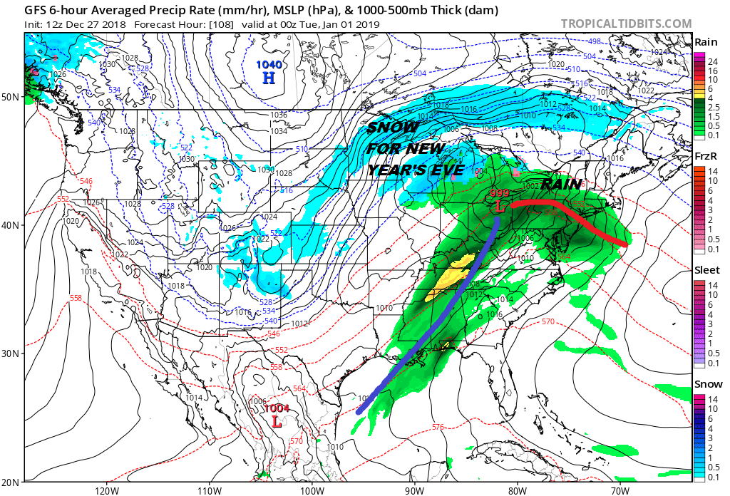
As the old year ends and the new year begins we continue to see the same weather pattern as another low comes out of the Plains and heads for the Eastern Great Lakes. This sets up another warm front and more rain for Monday as the rain moves in during the mid to late afternoon. if you are going to celebrate the arrival of the New Year outdoors, prepare for rain and temperatures in the 40s to near 50. The rain will be done by morning New Years Day with some sunshine developing and highs will be in the warm 50s to near 60. Colder air follows later next week.
MANY THANKS TO TROPICAL TIDBITS FOR THE USE OF MAPS
Please note that with regards to any tropical storms or hurricanes, should a storm be threatening, please consult your local National Weather Service office or your local government officials about what action you should be taking to protect life and property.


