FLOOD WATCH EXTENDED TO ALL OF NEW JERSEY EXCEPT THE NORTHEAST
1 TO 2 INCHES OF RAIN AREA WIDE..HIGHER AMOUNTS NJ WEST
INTO PENNSYLVANIA
FLORENCE CONTINUES TO STRENGTHEN AS IT HEADS WESTWARD
This has certainly been a very gloomy day with an early fall feel to the air, cloudy skies, and rain that has been steady but light. Dry air has kept the rain from advancing northward into the Hudson Valley & Connecticut but that will change tonight as dry air finally gives way. Flood Watch has now been extended to cover all of New Jersey except for the Northeast Counties. Rain amounts will range from up to 2 inches locally and higher amounts as you head inland of the coast.
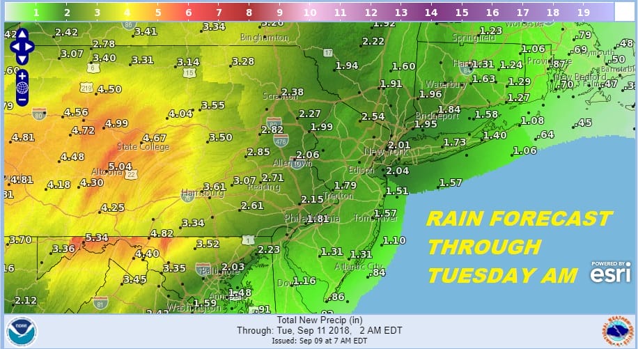
The satellite is loaded with clouds and they continue to stream eastward. Some of the moisture here is part of the remnants of Tropical Storm Gordon which explains the 4 to 5 inch forecast rain amounts for much Central Pennsylvania south into Northwest Maryland.
EASTERN SATELLITE

REGIONAL RADAR

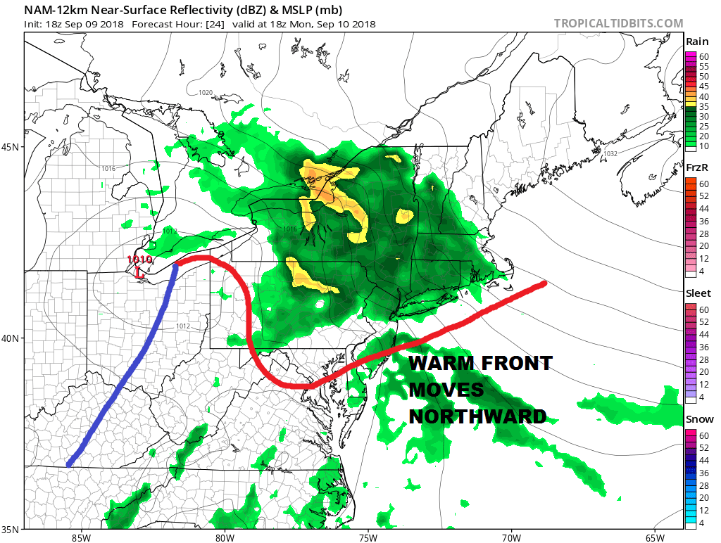
Local radars are busy with steady light rain that continues to move eastward. Rain will move into the Hudson Valley Connecticut and Eastern Long Island tonight and get heavier as the night goes on.
LOCAL RADAR NEW YORK CITY

LOCAL RADAR PHILADELPHIA


The rain continues into Monday as a warm front to the south struggles to move northward. Gradually during the day the warm front will north and the steady rain will come to an end from south to north as the day wears on. Temperatures will be in the upper 50s and lower 60s overnight and edge their way slowly higher through the 60s and then poking into the 70s once the warm front passes.
The cold front weakens as it moves east and completely falls apart as a strong upper high builds in from the east. This puts in warm humid conditions beginning of Tuesday and lasting all of next week. Tuesday we should be in the 80s with a shower or thunderstorm possible. Otherwise it is a mix of sun and clouds. Wednesday we will see sunshine very warm and humid conditions as tropical air takes over and Hurricane Florence begins its approach to the Carolinas.
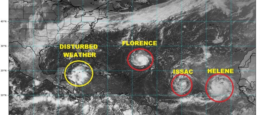
THE TROPICS ARE ON FIRE
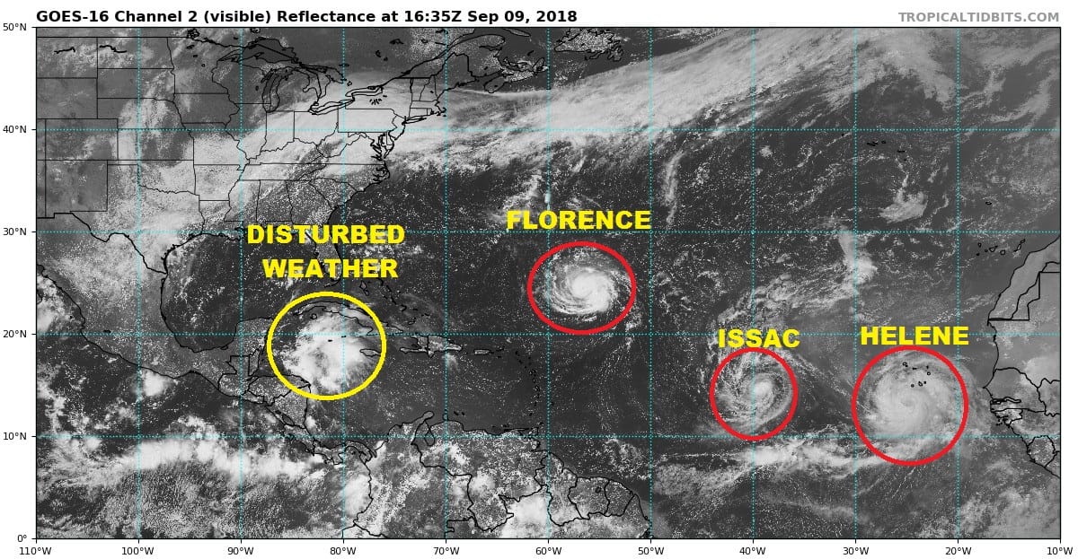
The satellite picture above shows 3 named storms 2 of which are hurricanes (Florence & Helene). Issac is almost a hurricane with 70 mph winds. We have disturbed weather in the Gulf of Mexico as well that will be moving into the Gulf of Mexico over the next few days. Conditions there are conducive for development. We could have 3 hurricanes on the map by Monday morning.

Florence of course remains front and center for the East Coast with the Carolina’s remaining in line for Florence late this week. Weather models this afternoon have’t changed much regarding Florence. They all get to the Carolina coast The map above is the GFS at 72 hours with the tracks of all three global models. All three stall it out and I have drawn in a stall zone. This is important since it could mean for big flooding rains for the Carolinas into Virginia. The upper high to the north splits in two as steering currents completely collapse. This is definitely going to be a huge forecast challenge for the week ahead.
Meanwhile Florence continues to strengthen and the new 5pm advisory winds are now 85 mph. The satellite presentation is excellent and Florence seems to be getting ready to go into a phase of faster or even rapid strengthening on Monday.
…NOAA HURRICANE HUNTER FINDS FLORENCE STRENGTHENING…
…FORECAST TO BECOME A MAJOR HURRICANE ON MONDAY…
SUMMARY OF 500 PM AST…2100 UTC…INFORMATION
———————————————-
LOCATION…24.4N 57.0W
ABOUT 720 MI…1160 KM SE OF BERMUDA
ABOUT 580 MI…935 KM NE OF THE NORTHERN LEEWARD ISLANDS
MAXIMUM SUSTAINED WINDS…85 MPH…140 KM/H
PRESENT MOVEMENT…W OR 270 DEGREES AT 7 MPH…11 KM/H
MINIMUM CENTRAL PRESSURE…975 MB…28.80 INCHES
WATCHES AND WARNINGS
——————–
There are no coastal watches or warnings in effect.
Interests in the southeastern and mid-Atlantic states should monitor
the progress of Florence.
DISCUSSION AND OUTLOOK
———————-
At 500 PM AST (2100 UTC), the center of Hurricane Florence was
located near latitude 24.4 North, longitude 57.0 West. Florence is
moving toward the west near 7 mph (11 km/h), and this general motion
is expected to continue today. A west-northwestward motion with an
increase in forward speed is expected by Monday, and that motion is
forecast to continue through mid-week. On the forecast track, the
center of Florence will move over the southwestern Atlantic Ocean
between Bermuda and the Bahamas Tuesday and Wednesday, and approach
the southeastern coast of the United States on Thursday.
Aircraft and satellite data indicate that maximum sustained winds
have increased to near 85 mph (140 km/h) with higher gusts. Florence
is forecast to rapidly strengthen to a major hurricane by Monday,
and is expected to remain an extremely dangerous major hurricane
through Thursday.
Hurricane-force winds extend outward up to 25 miles (35 km) from the
center and tropical-storm-force winds extend outward up to 125 miles
(205 km). Florence is forecast to become larger over the next few
days.
The estimated minimum central pressure from NOAA Hurricane Hunter
and satellite data is 975 mb (28.80 inches).
MANY THANKS TO TROPICAL TIDBITS FOR THE USE OF MAPS
Please note that with regards to any tropical storms or hurricanes, should a storm be threatening, please consult your local National Weather Service office or your local government officials about what action you should be taking to protect life and property.
LATEST JOESTRADAMUS ON THE LONG RANGE


