Issac Close To Hurricane Strength
Threat Grows for Southern Leeward Islands
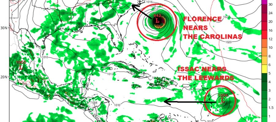
In what is a very busy Atlantic Basin at the moment we have 2 hurricane in Florence and Helene and we have Tropical Storm Issac between them which is just under hurricane strength and heading westward. Issac is the smallest of the 3 systems in terms geographic coverage but it is aiming for the Southern Leeward Islands for the middle of this coming week.
WIDE ATLANTIC TROPICAL SATELLITE

Conditions are favorable for Issac to strengthen to a hurricane in the next 24 hours. With Florence pulling away to the west there is plenty of room for Issac to develope without any interference from either Florence generated wind wind hear or shear of any kind . The ridge to the north of Issac takes it straight westward.
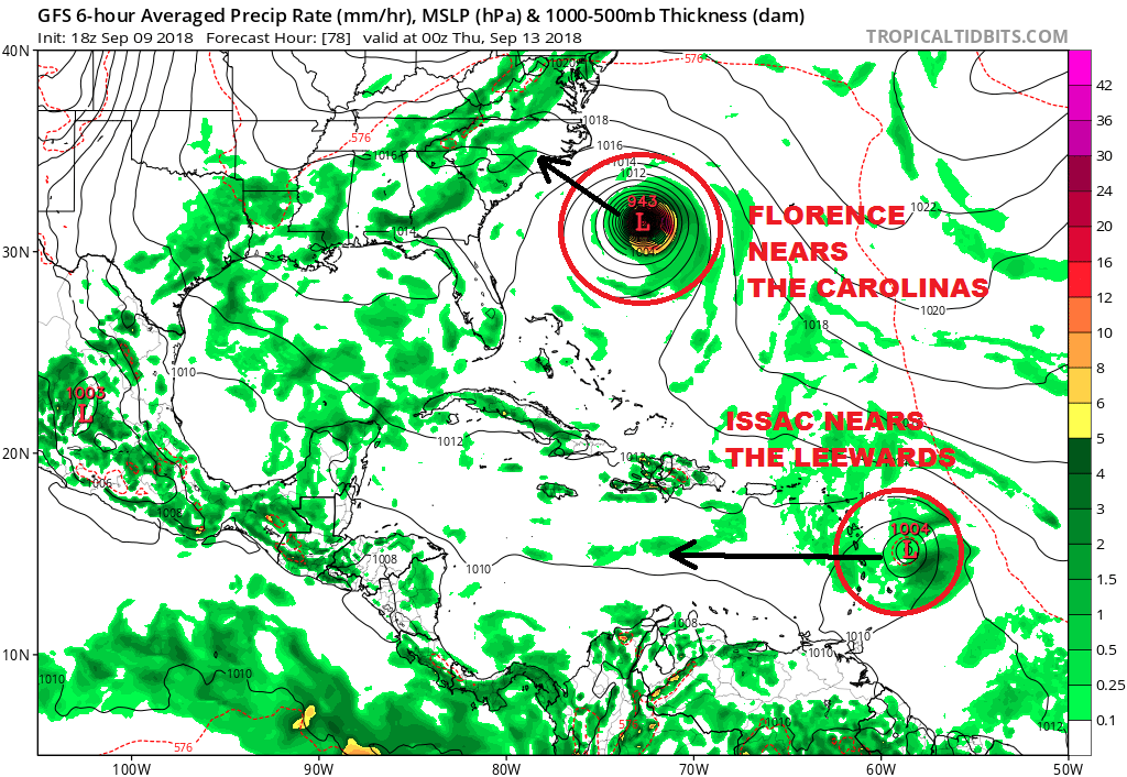
Last year the Leeward Islands dealt with two devastating category 5 hurricane in Irma and Maria and just missed a third with Jose. With Issac it seems minimal hurricane is the worst case scenario here though small systems sometimes can find a way to overdevelop. It seems that conditions will be favorable until it gets close to the Leewards where wind shear issues could get in the way. It also should start moving faster to the west which means watches could go up Monday for parts of the Northern Windward or Southern Leeward Islands.
5PM ISSAC ADVISORY
…ISAAC ALMOST A HURRICANE…
…MOVING FASTER TOWARD THE WEST OVER THE TROPICAL ATLANTIC…
SUMMARY OF 500 PM AST…2100 UTC…INFORMATION
———————————————-
LOCATION…14.5N 40.3W
ABOUT 1390 MI…2240 KM E OF THE WINDWARD ISLANDS
MAXIMUM SUSTAINED WINDS…70 MPH…110 KM/H
PRESENT MOVEMENT…W OR 275 DEGREES AT 12 MPH…19 KM/H
MINIMUM CENTRAL PRESSURE…997 MB…29.44 INCHES
WATCHES AND WARNINGS
——————–
There are no coastal watches or warnings in effect.
Interests in the Lesser Antilles should monitor the progress of
Isaac.
DISCUSSION AND OUTLOOK
———————-
At 500 PM AST (2100 UTC), the center of Tropical Storm Isaac was
located near latitude 14.5 North, longitude 40.3 West. Isaac is
moving toward the west near 12 mph (19 km/h) and is expected to
accelerate during the next 36 hours. A westward motion is forecast
to continue through the end of the week, with Isaac expected to
move across the Lesser Antilles and into the eastern Caribbean Sea
Wednesday night or Thursday.
Maximum sustained winds have increased to near 70 mph (110 km/h)
with higher gusts. Additional strengthening is forecast, and Isaac
is expected to become a hurricane tonight. Weakening is anticipated
to begin by the middle of the week while Isaac approaches the
Lesser Antilles.
Tropical-storm-force winds extend outward up to 45 miles (75 km)
from the center. The estimated minimum central pressure is 997 mb (29.44 inches).
THANKS TO TROPICAL TIDBITS FOR THE USE OF MAPS
Please consult your local National Weather Service office at weather.gov for the latest information on any tropical or storms or hurricanes that could be a threat to your area. Consult your local government officials regarding action you may need to take to secure life and property
FiOS1 News Weather Forecast For Long Island
FiOS1 News Weather Forecast For New Jersey
FiOS1 News Weather Forecast For Hudson Valley