
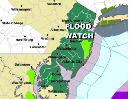
Flood Watch New Jersey Coastal Flooding Possible
Self Destructive Sunshine Into Midweek

Flood Watch New Jersey Coastal Flooding Possible
Self Destructive Sunshine Into Midweek
The gloom and doom weekend is now in the second half and we have a ton of moisture moving up the East Coast today. Clouds runs from New England to the Carolinas and rain which contains some heavier rain bands and some thunderstorms is moving up the coast and is overspreading the area from New Jersey to Southern New England.

Flood Watches are posted for all of New Jersey south to Delaware. Many areas have already gotten 3 or more inches of rain since Friday so another inch or so of rain on top of that will certainly set off some flooding issues especially in the usual vulnerable spots. We also have various Coastal Flood Advisories and Coastal Flood statements for parts of the New Jersey shore and Long Island for some minor coastal flooding at high tide. Winds from the east will increase this afternoon and evening to 20 to 30 mph in gusts.
SATELLITE

WEATHER RADAR

https://radar.weather.gov/ridge/standard/NORTHEAST_loop.gif
Radars are rather loaded south to Virginia and you can see some east west bands of heavy rain. The Storm Prediction Center has indicated general thunderstorm risk with a marginal risk for isolated severe thunderstorms from Southern New Jersey and Delaware southward. Low pressure will be moving northward up the east side of the Appalachians this afternoon and evening.
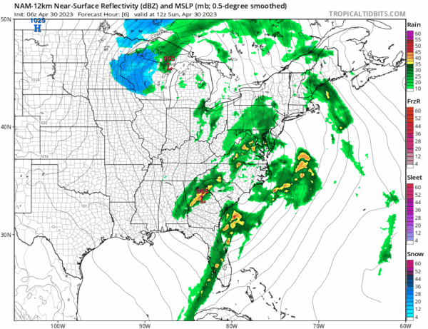
Once the low passes to the north later this evening rains will be coming to an end from south to north and weather conditions will improve into Monday morning. Temperatures today will be in the mid 50s coast to near or lower 60s well inland and south. Lows tonight will be in the 40s to around 50.
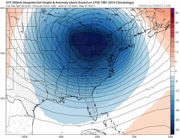
The issue for Monday through at least Thursday is the blocking pattern and a very strong upper air storm that is going to be over the Great Lakes Monday and then it will gradually strengthen further and move southeast to off the New Jersey coast late Wednesday. This is going to create a very cold and unstable atmosphere over the Northeast and Mid Atlantic states especially the interior. We may start Monday, Tuesday, & Wednesday with some sunshine but then clouds will quickly develop as the sun basically self destructs.

There may be a few showers inland Monday afternoon. Most highs will be in the upper 50s and lower 60s. Temperatures will be trending down and will run below average all week long. Tuesday and Wednesday will see any early sun quickly give way to overcast skies and showers. Highs Tuesday will be in the 50s to at best near 60.

Wednesday we will see the highest chance for showers and they will last into Thursday as the upper air storm moves southeast and a coastal low develops offshore. Temperatures Wednesday will also not get out of the 50s. Winds this week will also be an issue and it will be on the breezy side each day especailly in the late mornings and afternoons. The upper low will pull out late in the week and the atmosphere will gradually stabilize leading to a dry but rather cool finish to the week and the weekend.
BE SURE TO DOWNLOAD THE FREE METEOROLOGIST JOE CIOFFI WEATHER APP &
ANGRY BEN’S FREE WEATHER APP “THE ANGRY WEATHERMAN!
MANY THANKS TO TROPICAL TIDBITS & F5 WEATHER FOR THE USE OF MAPS
Please note that with regards to any severe weather, tropical storms, or hurricanes, should a storm be threatening, please consult your local National Weather Service office or your local government officials about what action you should be taking to protect life and property.


