Flash Flood Watch Scattered Thunderstorms Tonight Severe Weather Risk

Weather in 5/Joe & Joe Weather Show Latest Podcast
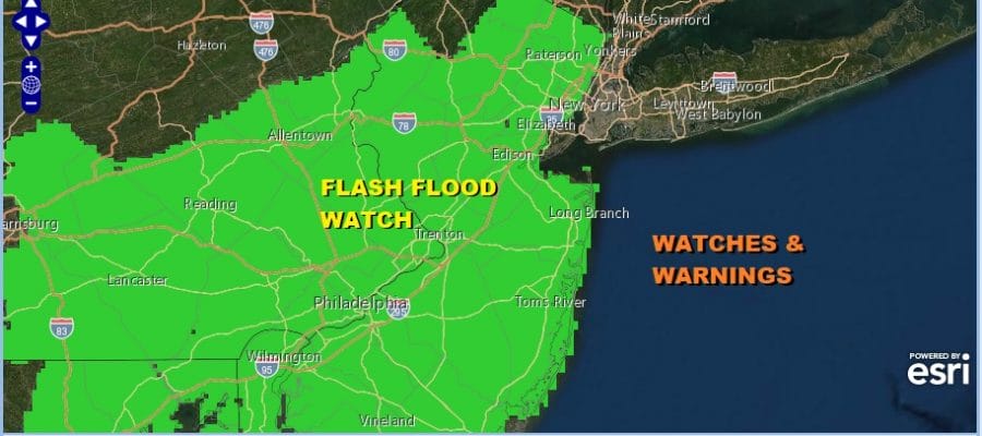
Flash Flood Watch Scattered Thunderstorms Tonight Severe Weather Risk
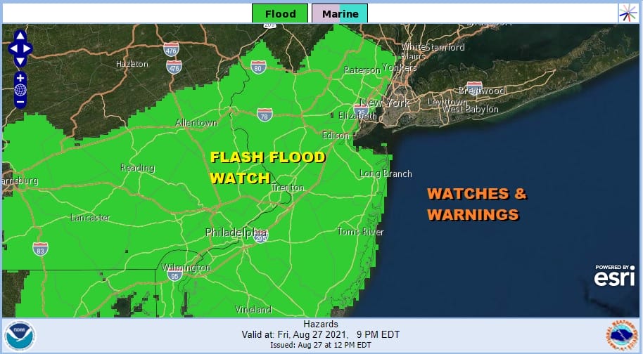
Daytime heating has taken temperatures up over 90 degrees once again and coupled with an unstable atmosphere we will see scattered thunderstorms develop. Given that the ground remains saturated from the rains of Henri, Flash Flood Watches have gone up for just about all of New Jersey, Eastern and Southeastern Pennsylvania south into Maryland. The Hudson Valley, NYC, Long Island and Southern New England are not in the flash flood watch zone as the risk for any thunderstorms is lower here. Also the Storm Prediction Center has added an area of slight risk for severe weather inside a larger area of marginal risk. The overall coverage of the risk zones remains unchanged from earlier today but some thunderstorms could become severe and produce strong winds as well as heavy rains. Slight risk of severe exits for South Central Pennsylvania south into Maryland.
SATELLITE

Local and regional radars are picking up on some developing scattered thunderstorms in Pennsylvania and parts of Northern New Jersey. More thunderstorms should show up later this afternoon into the evening hours. We have a cold front through later tonight and there could be a few storms with that front when it passes through.
WEATHER RADAR


There are no changes in the earlier outlook for the weekend. The front stalls in Southern New Jersey on Saturday and edges a little further south on Sunday. An onshore wind will make for cooler temperatures an and end to 90 degree highs for a couple of days. Both weekend days will feature cloudy to partly sunny skies with more clouds than sun. There will be some scattered clusters of showers and downpours but it doesn’t rain all the time. The weekend will feature dry periods.
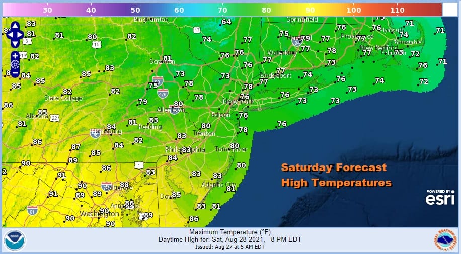
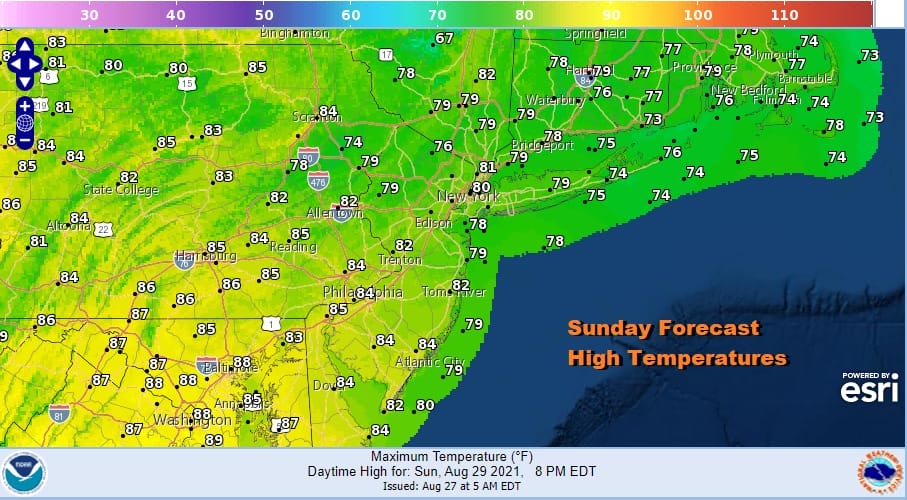
Temperatures will be in a wider range. North of the frontal boundary it will be in the 70s to near 80 while south of the front highs will be in the mid to upper 80s as the maps for Saturday and Sunday show. Monday brings another approaching cold front and the risk for late thunderstorms. Highs will be in the mid 80s to around 90 degrees.
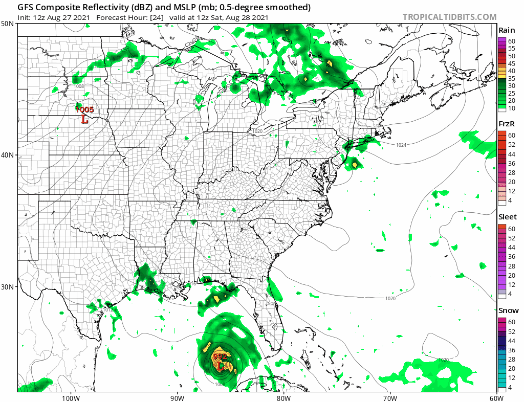
The standout on the latest GFS loop for the weekend and next week is Ida which will likely become a hurricane very soon. It is forecast to become a major hurricane and is targeting a landfall in Louisiana late Sunday or Sunday night. The remaining low and moisture will eventually head here producing soaking rain beginning early Wednesday and lasting into early Thursday morning. It could be another significant rainfall for our area but it will be followed by a shot of dry and cool air for the end of next week which then leads into the Labor Day holiday weekend. Autumn could be in the air!
BE SURE TO DOWNLOAD THE FREE METEOROLOGIST JOE CIOFFI WEATHER APP &
ANGRY BEN’S FREE WEATHER APP “THE ANGRY WEATHERMAN!

MANY THANKS TO TROPICAL TIDBITS & F5 WEATHER FOR THE USE OF MAPS
Please note that with regards to any severe weather, tropical storms, or hurricanes, should a storm be threatening, please consult your local National Weather Service office or your local government officials about what action you should be taking to protect life and property.


