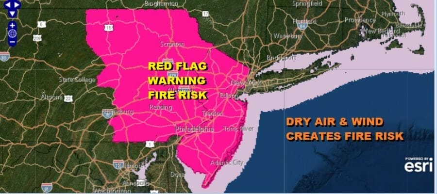
Fire Risks New Jersey Eastern Pennsylvania & Nearby
Weekend Outlook & Long Range

Fire Risks New Jersey Eastern Pennsylvania & Nearby
Weekend Outlook & Long Range
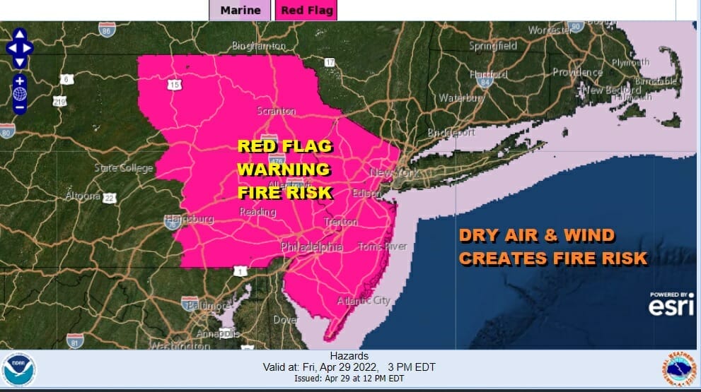
The strong storm over Nova Scotia continues to sit there stationary and that has created windy and very dry conditions in our area this afternoon. Very low relative humidity and gusty winds over 30 mph are a recipe for fire risk. Red Flag warnings are in effect for Eastern Pennsylvania and New Jersey this afternoon and evening so be extra cautious when handling flammable materials. Conditions are ripe for fires to spread quickly under these conditions.

Looking at the satellite views and radars we are seeing plenty of sunshine this afternoon from Southern New England to Northern Virginia and that will continue for the rest of the day. Temperatures are recovering from the morning lows in the 30s and we should see upper 50s to some lower 60s for highs this afternoon. Winds will still be gusty into tonight as skies will be clear. Lows will be in the 30s to near 40 or so.
SATELLITE

WEATHER RADAR

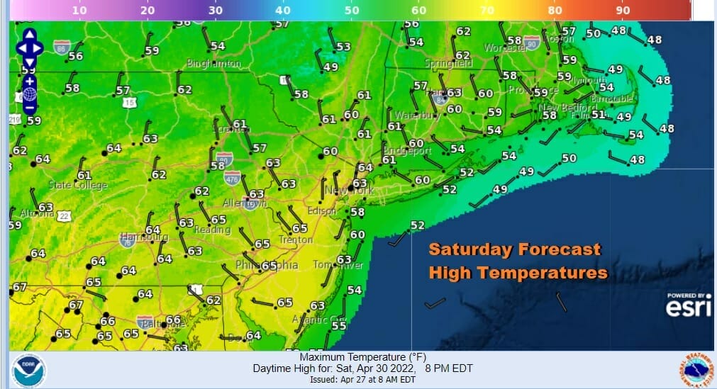
The blocking low pulls away Saturday so winds will finally ease up. We should have a good deal of sunshine. The low pulling away means the colder air will modify quickly under a strong late April sun. Highs Saturday afternoon should reach into the low and mid 60s.
Sunday should see just enough dry air hang on long enough to give us partly sunny skies. An approaching front from a storm in the Plains today will weaken as it heads east. Showers will make it late in the day into Southern Pennsylvania and points south but the showers look to be on the weak side. Most of the area should avoid them until Sunday night.

There will be a few showers around Sunday night into Monday as the front slowly makes progress eastward. The showers will be patchy so not everyone sees them but the risk is there. Monday will feature what I would describe as changeable sky conditions. Monday highs will be in the 60s.

The loop above is from Sunday afternoon into next Saturday and it continues to show 3 weather systems in play. The first is Sunday night into Monday. The second looks to be on Wednesday as a cold front moves through. We could see showers and possibly a thunderstorm when that front passes. This leaves us with what should be a “clean day on Tuesday with partly sunny skies & highs in the upper 60s to lower 70s. The third weather system for the end of the week is going to be interacting with a new blocking low developing in Eastern Canada. This might actually be a plus in that it could suppress the low and much of the rain further south so we will continue to monitor this going forward. That might be followed by a decent but cool weekend for Mother’s Day.
BE SURE TO DOWNLOAD THE FREE METEOROLOGIST JOE CIOFFI WEATHER APP &
ANGRY BEN’S FREE WEATHER APP “THE ANGRY WEATHERMAN!
MANY THANKS TO TROPICAL TIDBITS & F5 WEATHER FOR THE USE OF MAPS
Please note that with regards to any severe weather, tropical storms, or hurricanes, should a storm be threatening, please consult your local National Weather Service office or your local government officials about what action you should be taking to protect life and property.


