Father’s Day Very Warm Sunshine Storms Inland Monday Showers Tuesday

Weather in 5/Joe & Joe Weather Show Latest Podcast
Father’s Day Very Warm Sunshine Storms Inland Monday Showers Tuesday
Father’s Day is here and calendar summer arrives tonight shortly before midnight. We are set up for a very warm to hot day. Humidity levels haven’t come down much since yesterday. South and west of NYC humidity levels will remain rather high while in the Hudson Valley and Southern New England we are seeing a break in the humidity today. It won’t last however as the next cold front will begin to push warm humid air back northward tonight and Monday.

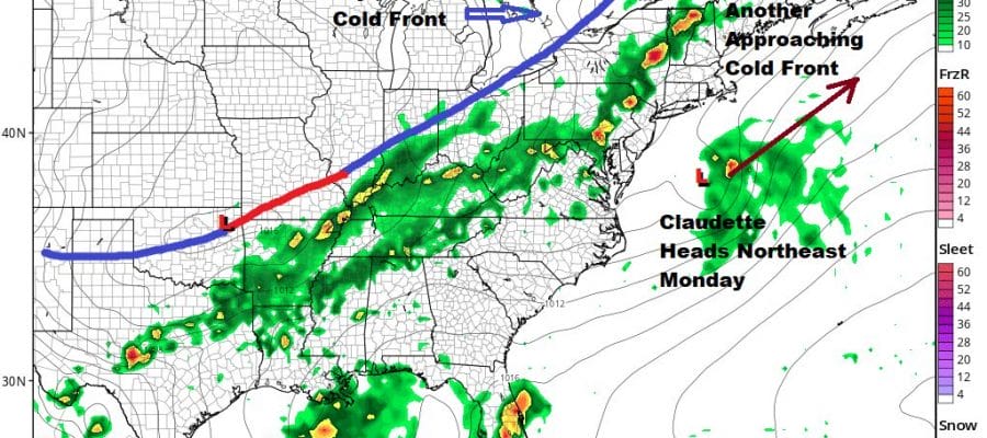
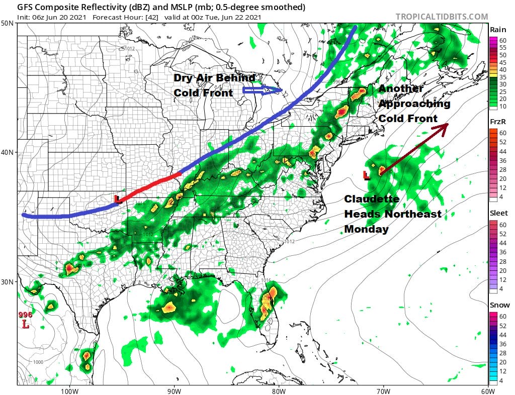
No thunderstorms are forecast today other than an isolated shower or thunderstorm possible well inland. Highs today will be in the upper 80s to lower 90s. The beach may be a good place to be. The satellite shows patchy clouds around mixed with areas of mostly sunny skies. To the south we have clouds and tropical moisture from Tropical Depression Claudette which is in North Georgia today producing flash flooding rains in the southeast. This system will pass to our south Monday and should regenerate into a tropical storm once it moves off the North Carolina coast.
SATELLITE

Monday is setting up to be a hot humid day ahead of the next cold front. A deep upper trough is digging into the Great Lakes southward and that will sweep Claudette in whatever form to the south and east. Meanwhile as the front approaches there will be a line of showers and thunderstorms late in the day tomorrow but they will be inland and not reach the coast at all.
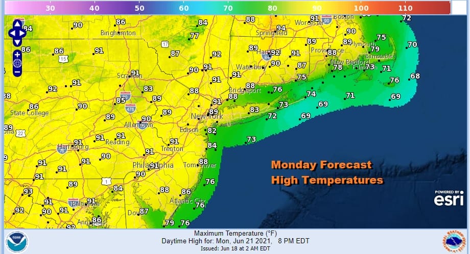
Monday is the first full day of summer and it will be hot and humid. Highs will reach the upper 80s to lower 90s. Humidity levels will be high and it will be extremely uncomfortable. Dew points will rise to a range of 65 to 70.
Monday does bring severe weather risk inland and the Storm Prediction Center has a slight risk of severe weather for much of Pennsylvania northeast into Northwestern New England. Marginal risk reaches into New Jersey to about NYC and points south and west. Thunderstorm risk here is more for Monday night and not so much for the daytime Monday.

This cold front will temporarily stall on Tuesday as it waits for another wave to develop and move northeast. This will finally push the front through but it does leave us at risk for showers and thunderstorms. The position of the front is right on the coast and the Storm Prediction Center is showing some risk for severe weather reaching into Central New Jersey. However if the front stalls a little further to the west, we could see this risk area pushed further north. Showers and some thunderstorms are likely Tuesday with highs in the 80s.

The payoff comes Wednesday through Friday as another delightfully dry air mass arrives from Canada. Dew points will drop into the 40s Wednesday and Thursday. We will sunshine both days. Highs Wednesday will be in the mid to upper 70s. Thursday highs will be in the upper 70s and lower 80s. Dry air will still be around Friday with highs between 80 and 85 degrees. This may be the last super dry cool air mass to visit the east as the pattern of deep troughs takes a break and we see more typical weather condtions for late June into the start of July.

BE SURE TO DOWNLOAD THE FREE METEOROLOGIST JOE CIOFFI WEATHER APP &
ANGRY BEN’S FREE WEATHER APP “THE ANGRY WEATHERMAN!
MANY THANKS TO TROPICAL TIDBITS FOR THE USE OF MAPS
Please note that with regards to any severe weather, tropical storms, or hurricanes, should a storm be threatening, please consult your local National Weather Service office or your local government officials about what action you should be taking to protect life and property.


