
Fast Moving Systems Easter Weekend Heavy Rain Potential Later Next Week, Snow Storm Interior New England

Fast Moving Systems Easter Weekend Heavy Rain Potential Later Next Week, Snow Storm Interior New England

Early Easter Weekend usually means we have weather systems to deal with and in the case of this weekend we have two weather sytems that are moving through. The first one is going to approach this evening from the Ohio Valley. It is a weak system but it will mean we will see some rain from this. The dayside however will be dry with any sunshine giving way to arriving clouds. Most highs will reach the 50s this afternoon.

On satellite and radar loops we can see clouds spreading east and southeast out of the Ohio Valley and gradually the radar will start to fill up with an area of showers. However this weather system is limited in nature as it moves along not adding any additional from the Atlantic Ocean. We are looking at about a 4 to 6 hour chance for some showers, mainly between 8pm and mostly done by 2am Sunday.
SATELLITE WITH LIGHTNING STRIKES

WEATHER RADAR

Once the first weather system is done we should see some improvement into Sunday morning as clouds move out. Easter Sunday should bring some sunshine but we have another weather system coming east from the Ohio Valley so clouds will likely come back later in the day. Any rain will hold off until well into Sunday evening so the dayside is dry. Temperatures Sunday will be topping out in the middle 50s to some 60 degree highs across Southern New Jersey and Southern Pennsylvania.

We begin a stretch of gloom & doom weather as showers that move in later Sunday night linger into Monday afternoon before this system move out of the way. Then we turn our attention to a stronger storm in the Central Plains that will be moving east northeast into the Northern Ohio Valley. This will bring more rain into the Northeast and Northern Mid Atlantic during the day Tuesday. This is going to be a very slow moving weather system and we will see rain lingering into Wednesday and Thursday for many areas from New Jersey to Southern New England. This is also going to produce a late season snow storm across many areas in Northern NY (North of I-90) and the northern half of New England. While all of this is going on you can expect temperatures to settle into the 40s for much of the time and the week ahead will have that miserable raw damp feel to it. We may have to wait for the end of the week or next weekend for weather conditions to genuinely improve.
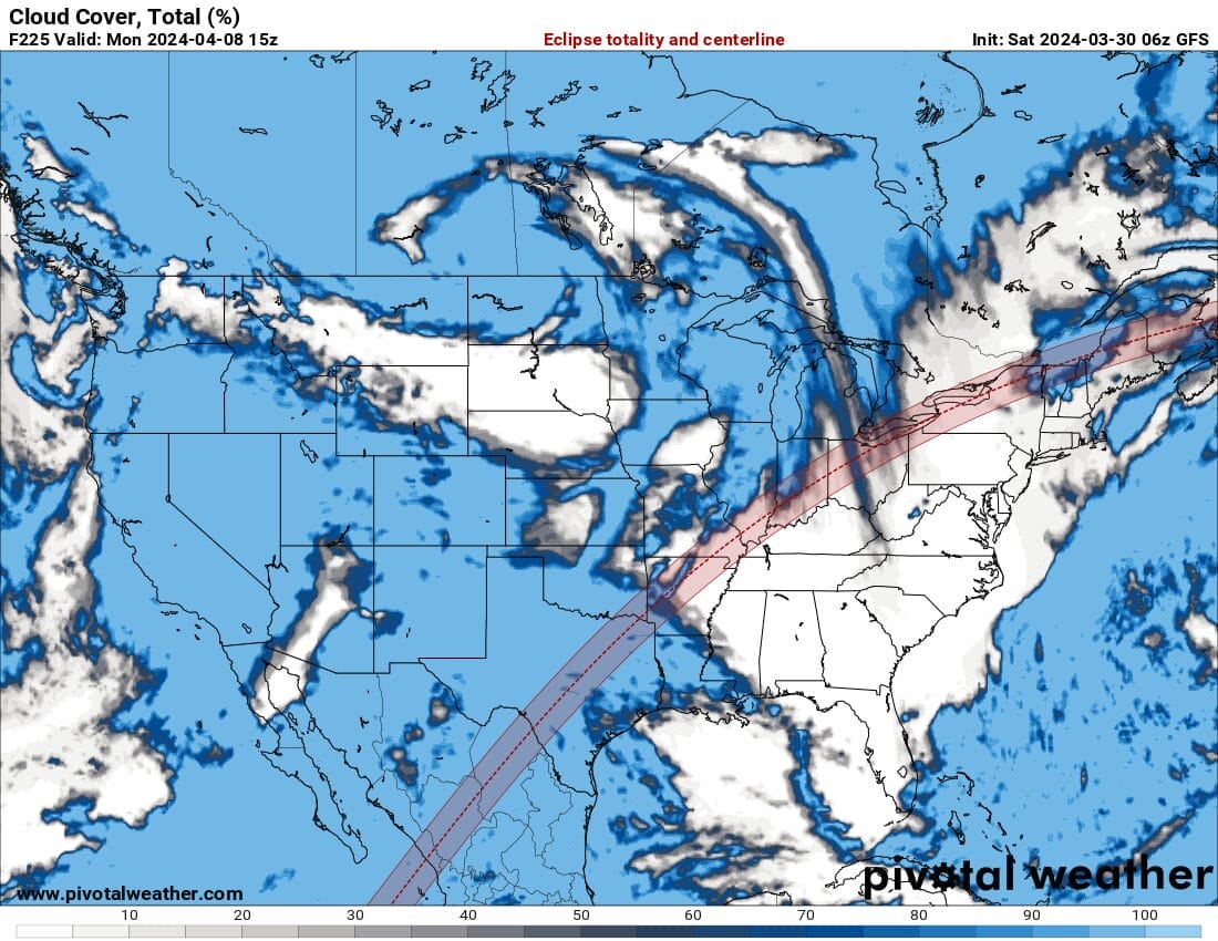
We are coming into range for seeing the weather forecast for the Solar Eclipse on Monday April the 8th. The map above shows the precent of cloud cover with the white areas indicating little or limited cloud cover while areas in blue or darker showing a larger percentage of cloud cover. The path of totality is shown on the map as well. It is still rather early in the game but at least we are beginning to get a sense of where weather conditions will be better for viewing. We will keep you updated over the next 9 days what it’s going to look like weatherwise for Eclipse Day.
BE SURE TO DOWNLOAD THE FREE METEOROLOGIST JOE CIOFFI WEATHER APP &
ANGRY BEN’S FREE WEATHER APP “THE ANGRY WEATHERMAN!
MANY THANKS TO TROPICAL TIDBITS FOR THE USE OF MAPS
Please note that with regards to any severe weather, tropical storms, or hurricanes, should a storm be threatening, please consult your local National Weather Service office or your local government officials about what action you should be taking to protect life and property.
(Amazon is an affilate of Meteorologist Joe Cioffi & earns commissions on sales.)


