Eclipse Day Brings Mix of Clear Skies Patchy High Clouds
Rain Wind Coming Thursday Into Early Friday

Eclipse Day Brings Mix of Clear Skies Patchy High Clouds
Rain Wind Coming Thursday Into Early Friday
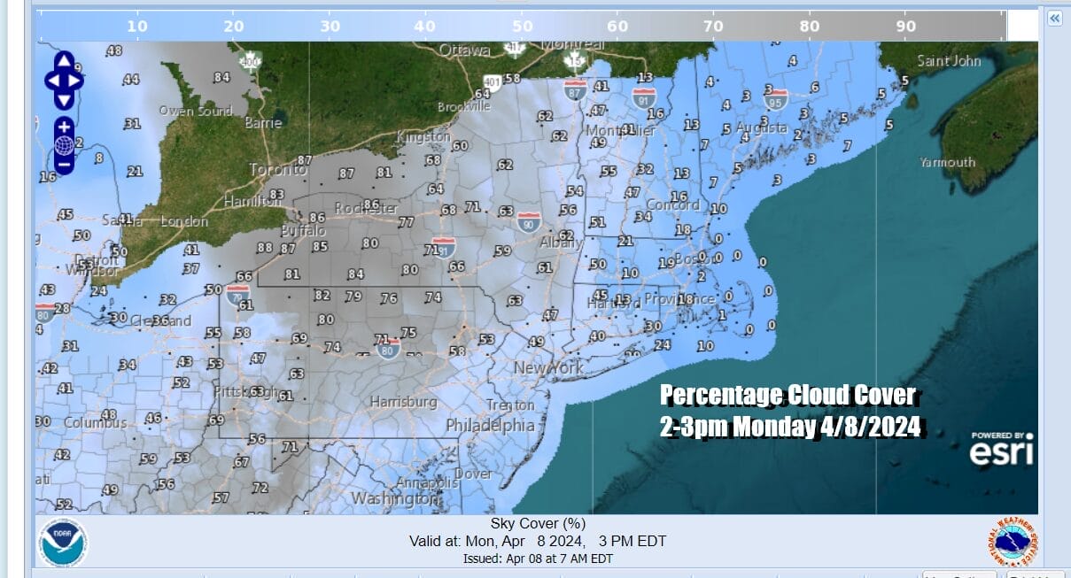
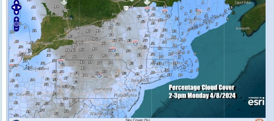
Today is the big day with a total eclipse of the sun. Checking the satellite loops today you will notice that we have an arm of clouds over the Great Lakes extending south into Western New York, Western Pennsylvania, and Ohio. There is also some light rain shower activity in this arm. It goes back to a storm in South Dakota that is moving northward and weakening so we should see this arm of moisture weaken to where the issue becomes how much in the way of high clouds (20-25k feet) will have this afternoon as the eclipse approaches totality.
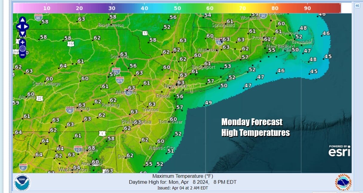
Northern NY (east of I-81) as well as Northern Vermont, Northern New Hampshire, and Maine are the best places and by now you are already there or well on your way. Those of you staying put in Eastern Pennsylvania to Southern New England we are looking at sunshine and some patchy high clouds. We will see temperatures warm up nicely with highs reaching into the 60s inland. Local sea breezes will keep south and east facing shorelines in the 50s.
SATELLITE WITH LIGHTNING STRIKES

WEATHER RADAR

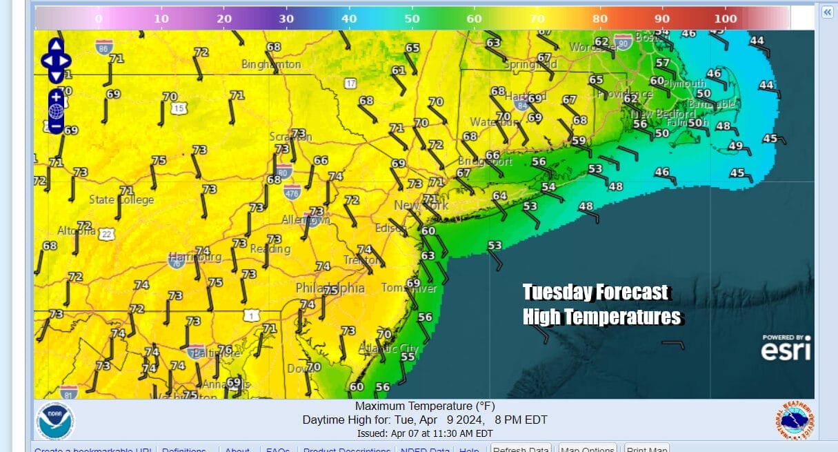
High pressure is squeezed between a storm well out to the east and this dying storm in the Dakotas and that should give us one more nice day before we have to deal with a stronger storm system that develops in the Gulf States over the next few days. Tuesday we see sunshine. Inland highs will reach into the 70s in many areas while south and east facing shorelines will top in the 50s to lower 60s. We should see a fair amount of sunshine Tuesday.
It seems that the new normal is that we have to deal with a major storm every week that outperforms when it comes to rain and wind. This week is no different as low pressure develops in the Gulf States. We will see heavy rain and severe weather spread across the South and Southeastern US in the coming days and rain through out the Gulf States. Tennessee and Ohio Valleys.

Some showers will be around Wednesday under cloudy skies with temperatures in the 50s thanks to an onshore flow. Then as low pressure moves northeast to the Great Lakes and a cold front approaches Thursday, we will see increasing south winds and rain overspreading the area. The rain is likely to be heavy at times and we will throw in the chance for thunderstorms. Thursday temperatures be in the mid 50s to lower 60s. Rainfall amounts will likely be in the 1 to 1.5 inches. Windy conditions continue on Friday as we shift from south to northwest. We could see wind advisory criteria being reached. We will dry out Friday with temperatures in the 50s. We will have more on this storm system in the coming days.
BE SURE TO DOWNLOAD THE FREE METEOROLOGIST JOE CIOFFI WEATHER APP &
ANGRY BEN’S FREE WEATHER APP “THE ANGRY WEATHERMAN!
MANY THANKS TO TROPICAL TIDBITS FOR THE USE OF MAPS
Please note that with regards to any severe weather, tropical storms, or hurricanes, should a storm be threatening, please consult your local National Weather Service office or your local government officials about what action you should be taking to protect life and property.
(Amazon is an affilate of Meteorologist Joe Cioffi & earns commissions on sales.)


