
DRY WEEK AHEAD BUT SOME RAIN COULD BE IN THE CARDS NEXT SUNDAY
NEW TROPICAL STORM DEVELOPING CARIBBEAN
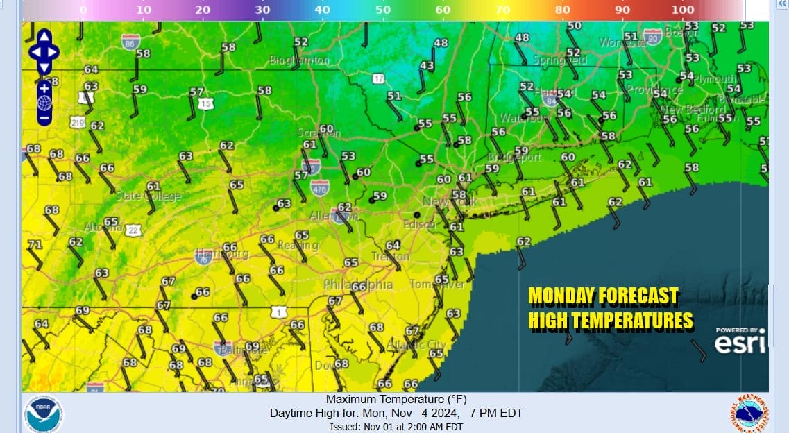
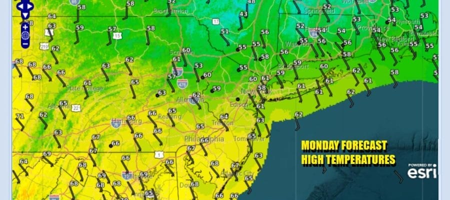
A new work week gets underway and the standout this morning is another warm front which is playing out to our north in Upstate NY and New England. There we see rain an showers on the regional radar. Most of that rain is sliding to the east. While that rain stays to the north we will have clouds and a southeast wind today and that will hold temperatures down somewhat. Most highs will be in the mid to upper 60s though north of NYC, a heavier overcast will keep temperatures mostly in the 50s to near 60.
SATELLITE WITH LIGHTNING STRIKES

WEATHER RADAR

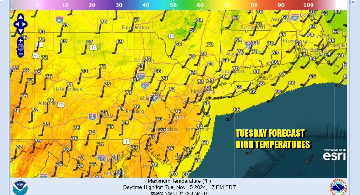
We will see this warm front pass through tonight so temperatures aren’t going to be going anywhere. lows will be in the 40s inland and low to mid 50s coast. Tuesday looks to be a sunny warm day with more of a southwest wind. High temperatures will reach the mid to upper 70s.
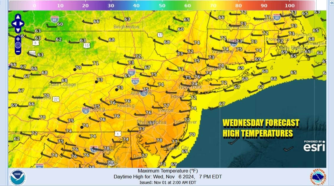
Wednesday looks to be a very warm day even though we do have another weak cold front passing through. That front will be dry so other than passing clouds and a wind shift you will hardly notice it go by. Skies should be no worse than partly sunny and highs will reach the upper 70s and lower 80s. That could set off another round of record breaking highs.
The next air mass for Thursday and Friday is one that brings cooler air but we will still be running above normal temperature wise Thursday and Friday. Some subtle changes will be occurring in the upper air set up that may actually allow for some rain to fall late in the weekend. We will see the strong east coast upper ridge to break down enough to allow low pressure to develop in the Southern and Central Plains later this week.

Also to the south of that upper ridge we will likely have Tropical Storm Rafael by late today as Potential Tropical Cyclone 18 organizes and strengthens as it heads northward. It may eventually be drawn into the developing low to the northwest and open up a flow of Gulf of Mexico moisture to get involved and head northeastward .

Until this weekend it leaves us with some sunshine Thursday and highs will be in the mid 60s to around 70. Friday will wrap up the week with sunshine and highs mostly in the 60s. Saturday looks to be dry and sunny but we are going to start mentioning the chance for some rain later Sunday into early next Monday.
BE SURE TO DOWNLOAD THE FREE METEOROLOGIST JOE CIOFFI WEATHER APP &
ANGRY BEN’S FREE WEATHER APP “THE ANGRY WEATHERMAN!
MANY THANKS TO TROPICAL TIDBITS FOR THE USE OF MAPS
Please note that with regards to any severe weather, tropical storms, or hurricanes, should a storm be threatening, please consult your local National Weather Service office or your local government officials about what action you should be taking to protect life and property.


