
Dry Weather & Sunshine Through Wednesday
Showers Likely Late Thursday As Front Nears
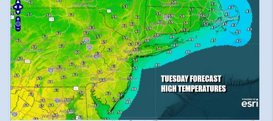
We have a bit of time in between storm systems and that leaves us in a decent spot today. Low pressure and a cold front are offshore. Weak high pressure is moving into the east and that means a good deal of sunshine today. High temperatures will be mostly in the low 60s area wide. We don’t see much in the way of cloud cover nor do we have an worries as far as the radars are concerned. Under clear skies and light winds tonight, most lows will be in the 30s with warmer urban areas in the lower 40s.
SATELLITE WITH LIGHTNING STRIKES

WEATHER RADAR

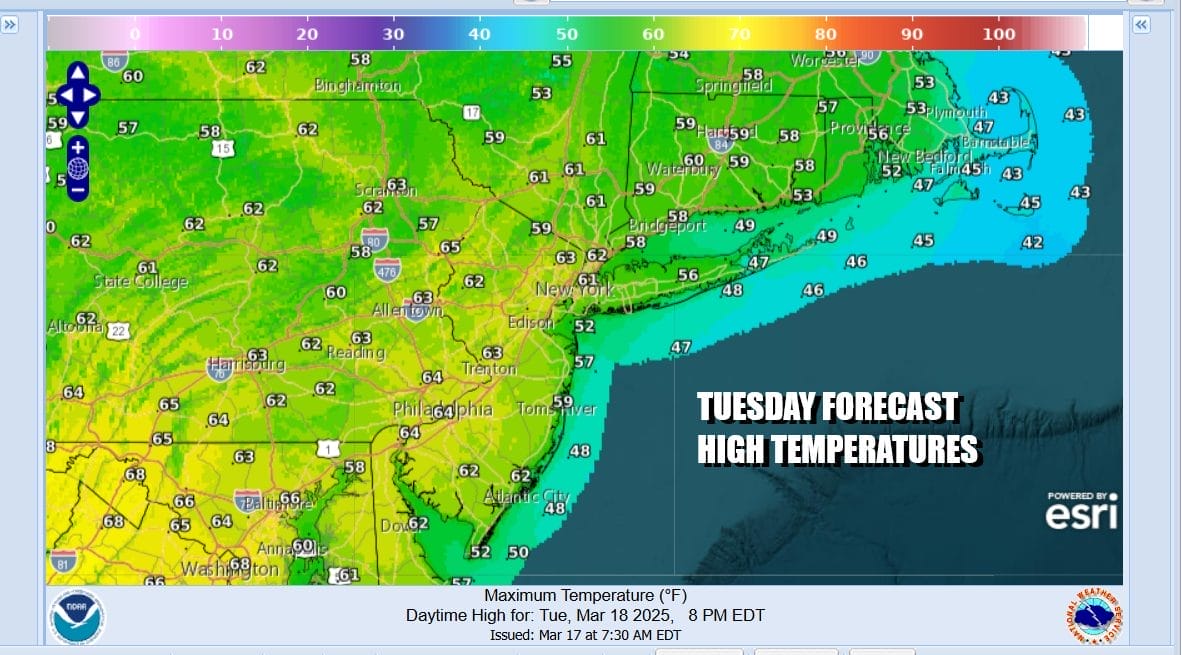
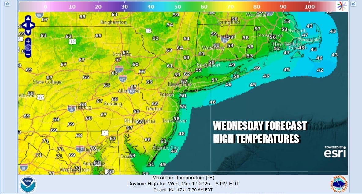
Wednesday is shaping up to be a very nice weather day across Eastern Pennsylvania to Southern New England. We will have plenty of sunshine from start to finish. There won’t be much in the way of cloud cover. High temperatures will reach the low and middle 60s except fo areas along the immediate coast with south and east facing shorelines. Ocean sea breezes will lower temperatures there by about 10 degrees or so.
Off to the east and well offshore we have a storm between the Carolinas and Bermuda that is dropping southeast and east. To the west we have a new storm developing in the Central Plains that heads to the Great Lakes. This storm is similar to the weekend storm system except that severe weather ahead of it won’t be as widespread. In the meantime the approaching cold front will arrive Thursday night along the East Coast.

Once the front moves offshore and slows down a storm develops in the front just to the east of New Jersey and south of Long Island. The gradient will tighten considerably later Thursday night into Friday. We look for showers and thunderstorms with the front Thursday evening and night with a steady period of rain during the early morning hours Friday. Winds will pick up from the north and gust to 40 mph or more late Thursday night into Friday afternoon.
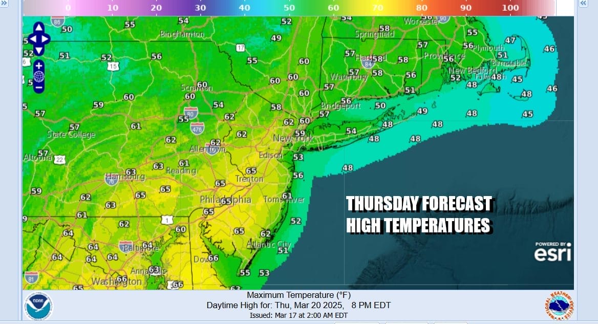
Ahead of all this Thursday look for sunshine with some arriving clouds. Highs will reach the upper 50s to mid 60s from north to south as winds turn south southeast ahead of the cold front. Showers and a thunderstorm or two will arrive Thursday evening. I do not expect any severe storms from this from what I am seeing at the moment. This could turn into a 1 to 2 inch rain producer from west to east. Weather conditions should improve somewhat Friday but it will be windy and cold with highs just in the 40s. The weekend looks a little warmer and dry.
BE SURE TO DOWNLOAD THE FREE METEOROLOGIST JOE CIOFFI WEATHER APP &
ANGRY BEN’S FREE WEATHER APP “THE ANGRY WEATHERMAN!
MANY THANKS TO TROPICAL TIDBITS FOR THE USE OF MAPS
Please note that with regards to any severe weather, tropical storms, or hurricanes, should a storm be threatening, please consult your local National Weather Service office or your local government officials about what action you should be taking to protect life and property.


