
Beautiful Wednesday But
Rain & Strong Winds Late Thursday Night Into Friday Morning
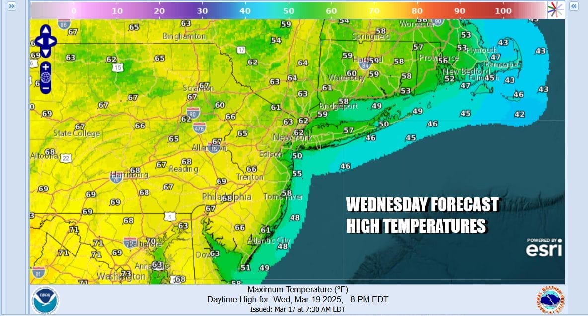
Today is Saint Joseph’s day which gets less play than Saint Patrick’s Day. Saint Joseph’s day this year is a day that I’m partial to for obvious reasons. We hare going to enjoy a good deal of sunshine and this is likely going to turn out to be the best weather day of this week. It is also the last day of astronomical winter as spring arrives Thursday morning. High temperatures today will be in the mid 60s to around 70 degrees in most places except for south and east facing shorelines in Coastal New Jersey, Long Island & Southern Connecticut where the south wind will keep temperatures in the cooler 50s.
SATELLITE WITH LIGHTNING STRIKES

WEATHER RADAR

The satellite loop shows a powerful ocean storm to the southeast in the Atlantic moving southeastward and that opens the door for low pressure and a cold front to the west, Clouds from this system are running northeastward for now and they won’t come close to Eastern Pennsylvania to Southern New England until sometime later Thursday.

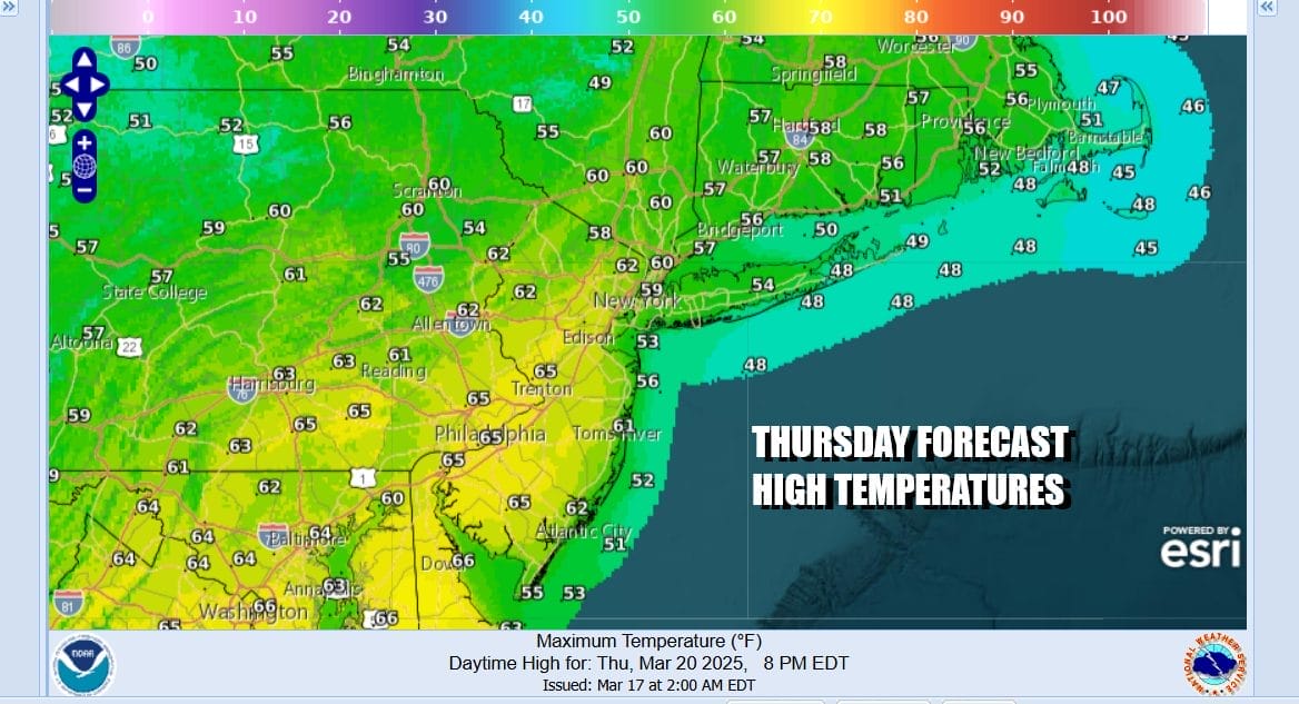
Ahead of all this we will be dry tonight and on the mild side with most lows in the low to mid 40s. Thursday is going to be a day where we see wider temperature ranges from northeast to southwest as a cold front approaches from the west and a warm front approaches from the south. Southeast to south winds will mean that from NYC and Northern New Jersey north and east most highs will be in the mid to upper 50s. South Jersey and Eastern Pennsylvania southward will likely see highs in the low to middle 60s.
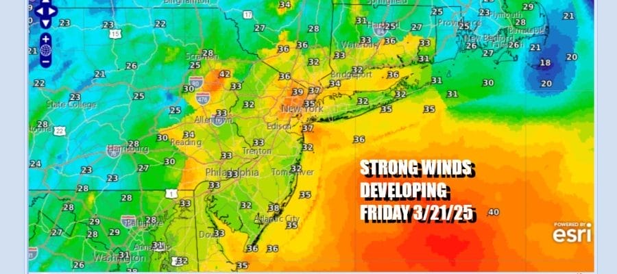
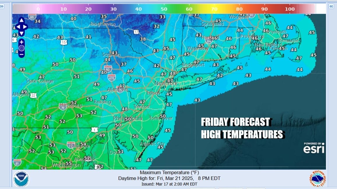
Clouds will be increasing throughout the day and we will see showers and perhaps a thunderstorm or two late in the day Thursday but certainly during Thursday evening and night. The front slows down on its approach and low pressure forms in Virginia on the front and heads northeastward into Friday morning near or just east of coastal New Jersey and south of Long Island. The gradient tightens and we will have a brief period of strong gusty winds late Thursday night into early Friday afternoon. Rainfall will average around a half to 3/4 inch. Rain should exit from west to east Friday morning with sky conditions improving in the afternoon. Highs Friday will only be in the 40s and the winds gusting to 30 to 40 mph will make it feel like its in the 20s.
The weekend leaves us with temperatures close to average for this time of year, A weak cold front will pass Saturday and there could be a brief shower in the afternoon as it goes by. Otherwise we will have a mix of sun and clouds and highs in the 50s. Sunday looks like a good day with sunshine and highs into the 50s. The next storm system is due to arrive Monday.
BE SURE TO DOWNLOAD THE FREE METEOROLOGIST JOE CIOFFI WEATHER APP &
ANGRY BEN’S FREE WEATHER APP “THE ANGRY WEATHERMAN!
MANY THANKS TO TROPICAL TIDBITS FOR THE USE OF MAPS
Please note that with regards to any severe weather, tropical storms, or hurricanes, should a storm be threatening, please consult your local National Weather Service office or your local government officials about what action you should be taking to protect life and property.


