Dry Seasonal Weather Through Sunday Downpours Monday
We are about to have our second nice weekend in a row and actually the Memorial Day holiday weekend was pretty good too so lets make it 3 in a row. It We do see patchy clouds on the satellite picture this morning but it is not a solid overcast. There are breaks in the cloud cover and we should be no worse than partly sunny for today. There is a lot of dry air to the north in Upstate NY, New England and the Great Lakes. That dry air is poised to move southward and it will eventually drive these clouds further south later today and tonight. Temperatures today will reach the mid 70s along the coast and lower 80s inland.
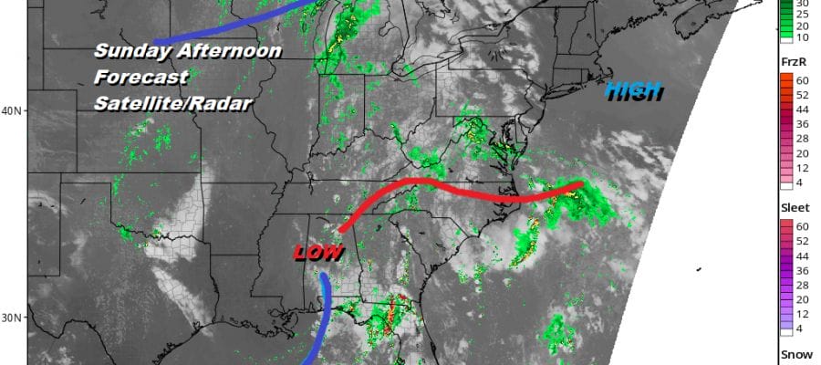
SATELLITE

REGIONAL RADAR

With rain out of the picture through Sunday we can focus on sunshine for Saturday and for most of Sunday. With high pressure building in from the north, it is keeping the rain you see on the regional radar in Virginia. It will only get so far north before it hits the wall of dry air that will like across Northern Virginia to the Delmarva Peninsula. Skies will be mainly clear tonight with lows in the 50s inland and lower 60s warmer urban centers and the coast. Saturday highs will be in the 70s along the coast and near or just over 80 inland thanks to a northeast wind.

Sunday will be dry with sunshine but there will be cloud issues developing in areas to the south of us. The high will start to pull out to the east and that will begin to allow southern moisture and rain to finally start moving northward. It comes no where close to us so Sunday will be no worse than partly sunny. The high moves out southeast of Cape Cod with a developing east or southeast wind. It should not cause any issues. Highs Sunday will be in the 70s to near 80..Coolest temperatures each day will be along the shore and coastal areas. Warmest areas will be inland west and north of the coast.

The low to the south in the Gulf States hooks up with that cold front in the Great Lakes and we will start to see downpours move in during the day Monday. Humidity will be up. Temperatures will be in the 70s. It will have a tropical feel here Monday and Tuesday until that cold front moves through later on Tuesday. Wednesday looks dry. That front stalls but we mentioned yesterday that if the upper flow were a little flatter it could keep a developing wave on that front further offshore. Another cold front is set to move through late Thursday but right now it seems we could be setting up for a nice warm Father’s Day weekend.
MANY THANKS TO TROPICAL TIDBITS FOR THE USE OF MAPS
Please note that with regards to any tropical storms or hurricanes, should a storm be threatening, please consult your local National Weather Service office or your local government officials about what action you should be taking to protect life and property.


