Dry Cooler Tuesday Onshore Flow Develops

Dry Cooler Tuesday Onshore Flow Develops
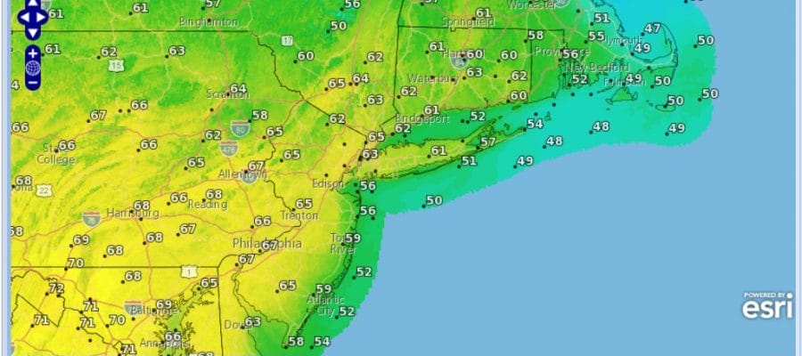
We are seeing a nice slice of dry air pushing into the Northeast and northern areas of the Middle Atlantic states today with much of the high cloudiness now well south. Lots of sunshine starts the day and temperatures continue to trend downward on Sunday as we shave off another 5 to 10 degrees off the daytime highs. Later today as an onshore wind develops temperatures along coastal locations of both east and south facing shore lines (New Jersey, Long Island, Connecticut) will see highs mainly in the 50s while areas inland should reach the low to mid 60s. Sunshine should be around all day and tonight skies will be clear with most lows in the 40s.
SATELLITE LOOP

REGIONAL RADAR

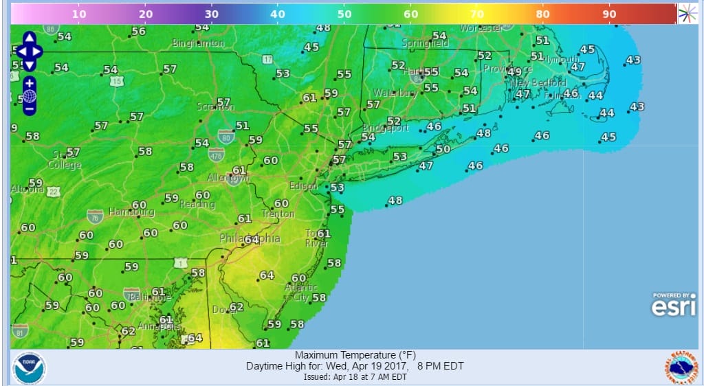
On Wednesday the onshore flow strengthens which means even cooler temperatures that will also impact inland areas. Sunshine will start the day but then as moisture from the stalled front to the south starts moving northward, clouds will increase. Also some low clouds will be moving in from the east at the same time. Highs will be in the 50s to lower 60s.
WEDNESDAY FORECAST HIGHS
The issue for Wednesday night into Thursday will be whether we get into some light rain or drizzle which i think is possible. A warm front will be setting up to our south so some rain is likely. Once the front passes it sets us up for milder temperatures and the risk for showers or a thunderstorm Thursday night and again on Friday. Temperatures could reach the 60s Thursday and perhaps into the 70s in some areas Friday before we cool off again for the weekend. More rain may be setting up for later Sunday into Monday.
 GET JOE A CIGAR IF YOU LIKE

LANDSCAPE COMPANIES FOR YOUR NEEDS
LONG ISLAND ROCKLAND COUNTY Connecticut

![]()

ROCKLAND COUNTY TRI STATE SNOW REMOVAL JOHNSTOWN PA


FiOS1 News Weather Forecast For Long Island
FiOS1 News Weather Forecast For New Jersey
FiOS1 News Weather Forecast For Hudson Valley
NATIONAL WEATHER SERVICE SNOW FORECASTS
LATEST JOESTRADAMUS ON THE LONG RANGE
Weather App

Don’t be without Meteorologist Joe Cioffi’s weather app. It is really a meteorologist app because you get my forecasts and my analysis and not some automated computer generated forecast based on the GFS model. This is why your app forecast changes every 6 hours. It is model driven with no human input at all. It gives you an icon, a temperature and no insight whatsoever.
It is a complete weather app to suit your forecast needs. All the weather information you need is right on your phone. Android or I-phone, use it to keep track of all the latest weather information and forecasts. This weather app is also free of advertising so you don’t have to worry about security issues with your device. An accurate forecast and no worries that your device is being compromised.
Use it in conjunction with my website and my facebook and twitter and you have complete weather coverage of all the latest weather and the long range outlook. The website has been redone and upgraded. Its easy to use and everything is archived so you can see how well Joe does or doesn’t do when it comes to forecasts and outlooks.
Just click on the google play button or the apple store button on the sidebar for my app which is on My Weather Concierge. Download the app for free. Subscribe to my forecasts on an ad free environment for just 99 cents a month.
Get my forecasts in the palm of your hand for less than the cost of a cup of Joe!


