Dry Cold Sunday Week Ahead Dry Until Friday As Cold Front Approaches

Dry Cold Sunday Week Ahead Dry Until Friday As Cold Front Approaches

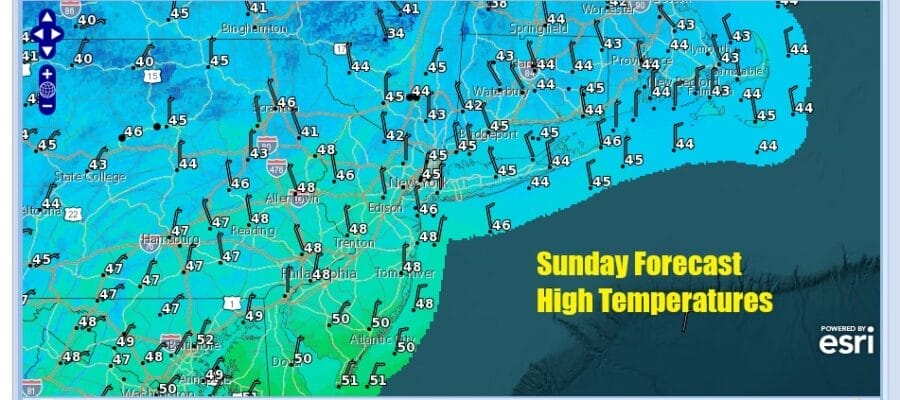
It has been a rain free but chilly weekend and today and tonight we see the coldest air of this air mass overhead. There is a little bit of instability that is creating some patchy cloud cover but there will be sunshine in the mix as well as a cold north wind. Temperatures this afternoon will be mostly in the 40s except closer to 50 in parts of South Jersey. That leads us to a cold night of clear skies tonight and Monday morning lows will be in the mid 20s to lower 30s. Radars are nice and quiet and we will not see any precipitation issues through Thursday.
SATELLITE WITH LIGHTNING STRIKES

WEATHER RADAR

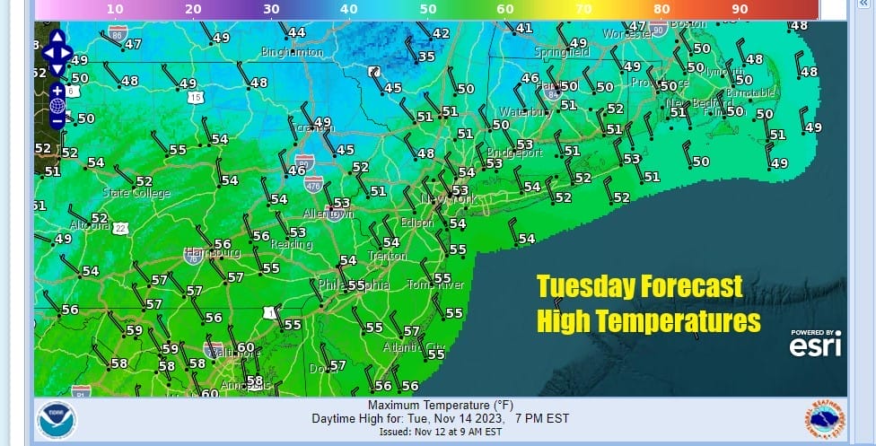
We have a weak cold front that will be moving through Monday along with an upper trough. Other than some clouds we don’t see any issues and it should be no worse than partly sunny. Highs Monday will be in the low to middle 50s.
Wednesday and Thursday we will continue to see some sunshine for both days and temperatures will be heading a little higher Most highs Wednesday will be in the mid to upper 50s. Thursday highs will reach the upper 50s to lower 60s. Friday will be the warmest day of the week but we will start to see weather conditions deteriorate as a cold front approacjes from the west and low pressure moves up the coast offshore.

Low pressure in the southern stream starts in the Gulf States and moves off the Southeast coast and heads north east but it will remain separate from the cold front. However the front will have enough energy to set off showers Friday afternoon from west to east. As long as everything moves along the showers will be mostly done by Saturday morning. Friday highs will be in the low to mid 60s. Next weekend should be mostly dry and colder but nothing excessive. Next week we have Thanksgiving week and there are some questions over weather another storm system will impact the Eastern US sometime Tuesday or Wednesday which of course are big travel days ahead of Thanksgiving. We will be watching models carefully to see if weather gets complicated with potential storm development.
BE SURE TO DOWNLOAD THE FREE METEOROLOGIST JOE CIOFFI WEATHER APP &
ANGRY BEN’S FREE WEATHER APP “THE ANGRY WEATHERMAN!
MANY THANKS TO TROPICAL TIDBITS FOR THE USE OF MAPS
Please note that with regards to any severe weather, tropical storms, or hurricanes, should a storm be threatening, please consult your local National Weather Service office or your local government officials about what action you should be taking to protect life and property.
(Amazon is an affilate of Meteorologist Joe Cioffi & earns commissions on sales.)


