Drought Relief Still On Course
Drought Relief Still On Course
Rainfall last night wasn’t much which was on course with the front that pushed on through. The satellite loop shows cloud cover mostly offshore but still close by. Meanwhile over the Great Lakes we have that upper low that is getting ready to drop south southeastward into Eastern Kentucky over the next few days. This should set us up for some much needed rain but how much remains the big question. No issues tonight though with clear skies just inland of the coast. Along the coast we will be watching those coastal clouds which will be backing in from the east late tonight and on Wednesday. Where it s clear overnight it drops to the lower 50s across Northern New Jersey, Northeastern Pennsylvania and in the Hudson Valley while it will be closer to 60 along shore areas and warmer urban centers. Wednesday those clouds will start backing in from the east and also swinging up from the south. An onshore flow will be setting up which will keep things damp and dismal beginning Wednesday night and lasting probably through Saturday.


Radars are showing rain offshore with the front and moving generally northeastward. No rain is indicated anywhere on land so we will be dry into at least Wednesday afternoon.


Thursday we will begin to see on and off rain that lasts into the weekend. Models have been on somewhat of a downtrend in rainfall amounts shifting the heavier rains south and southwest of our area. This is because the cutoff low will be a little to far west to put us in the heart of the heavy rain. That could change but I would think we should see at least what the GFS model is now showing for total rainfall through Sunday.
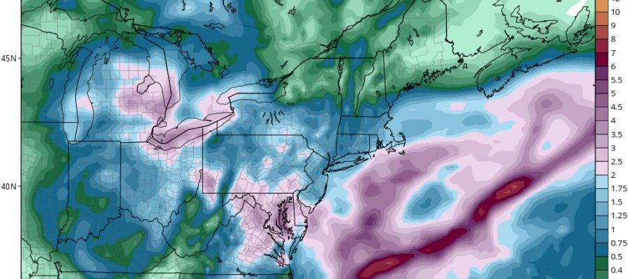
DROUGHT RELIEF GFS RAINFALL TOTALS THROUGH SUNDAY
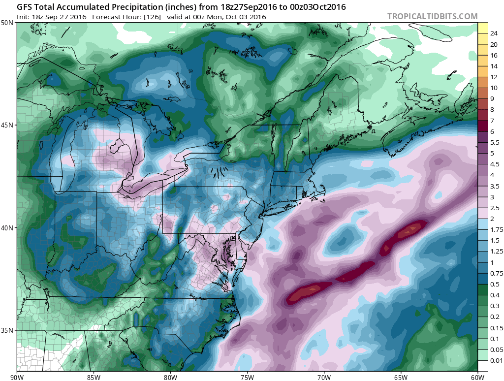
The model still brings 1 to 2 inches of rain over much of the area with 3 to 5 inches in Southeastern Pennsylvania southward to Northeastern Virginia. We may not see much sun around here until Sunday at the earliest.
Next week a big high builds down from Eastern Canada which sets a strong onshore flow up and down the Eastern Seaboard. To the south in the Bahamas is what could be Hurricane Mathew as all the weather models show this. As of 6pm the Air Force plane investigating the disturbance east of the Windward Islands did not find a closed circulation yet. However the National Hurricane Center says this could become a tropical depression or tropical storm tonight or on Wednesday as it continues to move westward.

For the latest on this tropical system check my latest JOESTRADAMUS post which takes a look at today’s European model and discusses the possibilities.
WINTER WEATHER OUTLOOK VIDEOS
In case you missed them I’ve been previewing the upcoming winter in a series of posts and videos. Here are the first 2. More will be coming along. Links to the latest posts are below.
EASTERN PENNSYLVANIA
NEW JERSEY
LONG ISLAND AND NEARBY
WINTER 2016-2017 PART 4 EASTERN PENNSYLVANIA
WINTER 2016-2017 PART 3 NEW JERSEY
WINTER 2016-2017 PART 1 OCEAN WATER TEMPERATURES
WINTER 2016-2017 PART 2 ARCTIC SEA ICE AND SIBERIAN SNOW COVER
FiOS1 News Weather Forecast For Long Island
FiOS1 News Weather Forecast For New Jersey
FiOS1 News Weather Forecast For Hudson Valley
NATIONAL WEATHER SERVICE SNOW FORECASTS
LATEST JOESTRADAMUS ON THE LONG RANGE

Weather App

Don’t be without Meteorologist Joe Cioffi’s weather app. It is really a meteorologist app because you get my forecasts and my analysis and not some automated computer generated forecast based on the GFS model. This is why your app forecast changes every 6 hours. It is model driven with no human input at all. It gives you an icon, a temperature and no insight whatsoever.
It is a complete weather app to suit your forecast needs. All the weather information you need is right on your phone. Android or I-phone, use it to keep track of all the latest weather information and forecasts. This weather app is also free of advertising so you don’t have to worry about security issues with your device. An accurate forecast and no worries that your device is being compromised.
Use it in conjunction with my website and my facebook and twitter and you have complete weather coverage of all the latest weather and the long range outlook. The website has been redone and upgraded. Its easy to use and everything is archived so you can see how well Joe does or doesn’t do when it comes to forecasts and outlooks.
Just click on the google play button or the apple store button on the sidebar for my app which is on My Weather Concierge. Download the app for free. Subscribe to my forecasts on an ad free environment for just 99 cents a month.
Get my forecasts in the palm of your hand for less than the cost of a cup of Joe!

MENTION JOE CIOFFI AND GET A 5% DISCOUNT


