Drought Area Rainfall 1-2 Inches
Drought Area Rainfall 1-2 Inches
Drought area rainfall wound up outperforming the models in a big way. Not only did we get more than double or triple the model forecasts but the rain fell in areas that need it the most to the west and north and less so to the east.
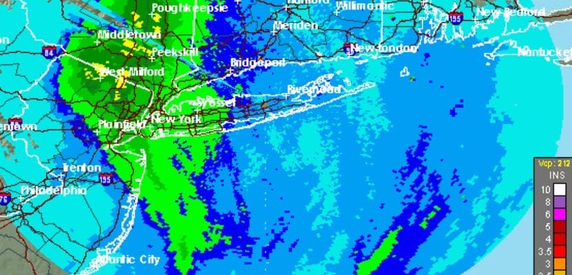
DROUGHT AREA RAINFALL TOTALS
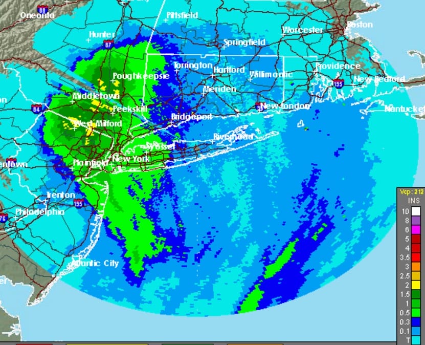
Amounts of 2 to 2 1/2 inches fell over parts of Northern New Jersey and the Hudson Valley with 1 inch plus amounts over a large area. This was a nice surprise considering the drought’s stranglehold over the area. There was even some lightning and thunder reported in some areas. Now the rains have moved to the north and weather conditions will begin to improve as we move into the evening though clouds could take awhile to get out of the way.


The weather over the next 3 days will be quiet and mild with sunshine Wednesday through Friday with just some occasional clouds. The next threat will trigger the bigger change as the pattern shifts over the weekend and into Thanksgiving week. Colder air is coming along with another threat for rain over the weekend. It will also be the first major snows for parts of Western & Central Pennsylvania, upstate NY and New England.

Im using the Canadian model above and its snowfall forecast as it is a compromise between the less robust GFS and the European Model which lines up the same as the Canadian with at least double these amounts. We will discuss this further later today.
MANY THANKS TO TROPICAL TIDBITS FOR THE WONDERFUL USE OF THE MAPS
WINTER 2016-2017 FORECAST LINKS
SNOW REMOVAL COMPANIES FOR YOUR WINTER NEEDS
LONG ISLAND ROCKLAND COUNTY Connecticut

![]()

FiOS1 News Weather Forecast For Long Island
FiOS1 News Weather Forecast For New Jersey
FiOS1 News Weather Forecast For Hudson Valley
NATIONAL WEATHER SERVICE SNOW FORECASTS
LATEST JOESTRADAMUS ON THE LONG RANGE
Weather App

Don’t be without Meteorologist Joe Cioffi’s weather app. It is really a meteorologist app because you get my forecasts and my analysis and not some automated computer generated forecast based on the GFS model. This is why your app forecast changes every 6 hours. It is model driven with no human input at all. It gives you an icon, a temperature and no insight whatsoever.
It is a complete weather app to suit your forecast needs. All the weather information you need is right on your phone. Android or I-phone, use it to keep track of all the latest weather information and forecasts. This weather app is also free of advertising so you don’t have to worry about security issues with your device. An accurate forecast and no worries that your device is being compromised.
Use it in conjunction with my website and my facebook and twitter and you have complete weather coverage of all the latest weather and the long range outlook. The website has been redone and upgraded. Its easy to use and everything is archived so you can see how well Joe does or doesn’t do when it comes to forecasts and outlooks.
Just click on the google play button or the apple store button on the sidebar for my app which is on My Weather Concierge. Download the app for free. Subscribe to my forecasts on an ad free environment for just 99 cents a month.
Get my forecasts in the palm of your hand for less than the cost of a cup of Joe!


