DOWNLOAD MY NEW FREE JOESTRADAMUS WEATHER APP FOR ALL DEVICES
THE APP IS ABSOLUTELY FREE TO ALL BUT CONSIDERING SUBSCRIBING TO PATREON FOR A WEATHER EXPERIENCE FREE OF ADS, EXCLUSIVE VIDEOS FOR MEMBERS ONLY AND MUCH MORE…STARTS AT $2 A MONTH..MESSAGE ME AT ANY TIME
Downpours Thunderstorms Firing Up Tonight 70s Saturday
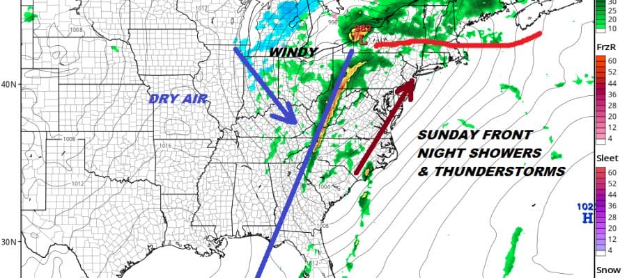
We are watching a cold front swinging east from Western Pennsylvania being driven by the Plains blizzard of the last 2 days that is now a weakening low heading for Lake Superior. The front is actually a bit lively this evening with a line of showers and thunderstorms. Further east and over us this evening we are seeing a lead area of showers moving through but the bulk of the rain comes overnight into Saturday morning.
SATELLITE

REGIONAL RADAR

Radars are beginning to get busy both regionally and locally with showers moving through parts of the area right now and then those heavier downpours to the west. Those come through overnight into Saturday morning and the total rainfalls are being nudged higher due to the impressive radars we are seeing. Three quarters of an inch to an inch and a quarter of rain is likely for most.
LOCAL RADAR NEW YORK CITY

LOCAL RADAR PHILADELPHIA


Saturday remains on course and we expect sunshine to break through the clouds. With no cold air to speak of it will be very easy to take temperatures into the 70s to near 80 inland areas of New Jersey and the Hudson Valley and mid 60s to mid 70s are possible over coastal areas as well. All of this depends on how quick the sun comes out.

Sunday is Palm Sunday and the next cold front approaches. Sunday could very well turn out to be a repeat of today with clouds, breaks of sun, and some spot showers into Sunday evening before the main cold front comes through Sunday night with heavier downpours and perhaps a thunderstorm or two. Sunday’s highs will be mostly in the 60s to near 70. Showers will linger Monday morning and then weather conditions should improve Monday afternoon with gusty northwest winds developing and leftover clouds with some sun. Monday’s highs will be in the upper 60s and lower 70s before it turns cooler for Tuesday.
MANY THANKS TO TROPICAL TIDBITS FOR THE USE OF MAPS
Please note that with regards to any tropical storms or hurricanes, should a storm be threatening, please consult your local National Weather Service office or your local government officials about what action you should be taking to protect life and property.


