Downpours Developing Moving Northeast
Downpours Developing Moving Northeast
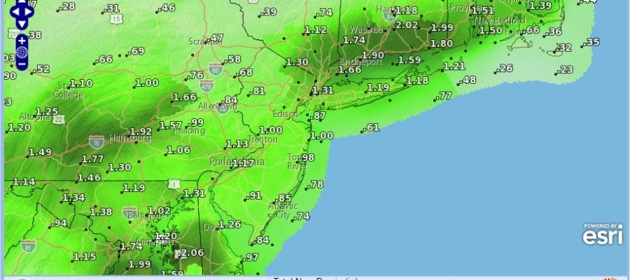
We are seeing some downpours developing on the radars and there will be the risk of downpours overnight into Friday morning. It will not be raining all the time but at times some of the rain could be heavy. Some areas will get very little while others could see an inch or two.
DOWNPOURS DEVELOPING FORECAST RAIN AMOUNTS
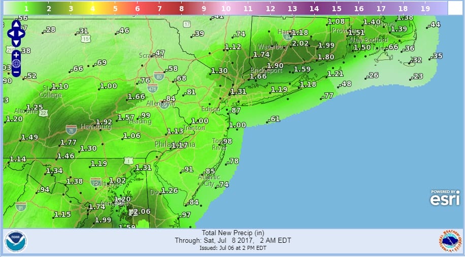
There will be a large amount in the variability of the rain amounts. Low pressure is coming out of the Tennessee Valley and will pass just east of New Jersey Friday morning. There is a warm front lying to our south at the moment which accounts for lots of cloud cover around. Some areas north of the coast are seeing some breaks of sunshine this afternoon. There is a little bit of everything for everyone.
SATELLITE LOOP

REGIONAL RADAR

LOCAL RADAR NEW YORK CITY

LOCAL RADAR PHILADELPHIA


After these downpours move out Friday morning, we will go to a mix of sun and clouds. There could be another shower or thunderstorm late in the day.
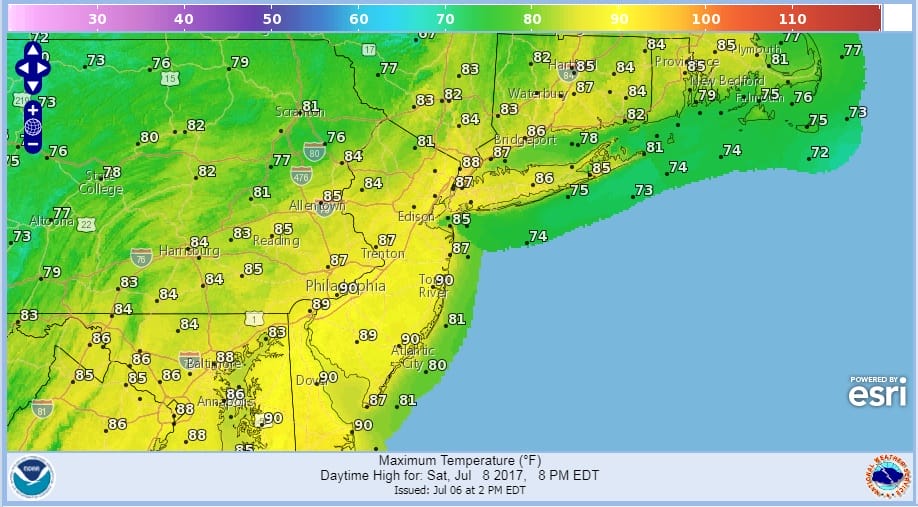
Then we transition to the weekend which will start with a mix of sun and clouds on Saturday with the chance for a late day thunderstorm. They should be scattered in nature. Sunday we go to mostly sunny skies. High temperatures both days wil be in the 80s though some spots on Saturday could see 90 with a west wind. Sunshine will continue on Monday with highs mostly in the 80s.
 GET JOE A CIGAR IF YOU LIKE

LANDSCAPE COMPANIES FOR YOUR NEEDS
LONG ISLAND ROCKLAND COUNTY Connecticut

![]()

ROCKLAND COUNTY TRI STATE SNOW REMOVAL JOHNSTOWN PA


FiOS1 News Weather Forecast For Long Island
FiOS1 News Weather Forecast For New Jersey
FiOS1 News Weather Forecast For Hudson Valley
NATIONAL WEATHER SERVICE SNOW FORECASTS
LATEST JOESTRADAMUS ON THE LONG RANGE
Weather App

Don’t be without Meteorologist Joe Cioffi’s weather app. It is really a meteorologist app because you get my forecasts and my analysis and not some automated computer generated forecast based on the GFS model. This is why your app forecast changes every 6 hours. It is model driven with no human input at all. It gives you an icon, a temperature and no insight whatsoever.
It is a complete weather app to suit your forecast needs. All the weather information you need is right on your phone. Android or I-phone, use it to keep track of all the latest weather information and forecasts. This weather app is also free of advertising so you don’t have to worry about security issues with your device. An accurate forecast and no worries that your device is being compromised.
Use it in conjunction with my website and my facebook and twitter and you have complete weather coverage of all the latest weather and the long range outlook. The website has been redone and upgraded. Its easy to use and everything is archived so you can see how well Joe does or doesn’t do when it comes to forecasts and outlooks.
Just click on the google play button or the apple store button on the sidebar for my app which is on My Weather Concierge. Download the app for free. Subscribe to my forecasts on an ad free environment for just 99 cents a month.
Get my forecasts in the palm of your hand for less than the cost of a cup of Joe!


