
Crazy Weather Week Ahead

MENTION JOE CIOFFI AND GET A 5% DISCOUNT
I guess we can say that we have begun what will be a wild 7 to 10 days ahead of us. It began today I suppose with temperatures that reached 80 across parts of New Jersey and the Hudson Valley of NY while not getting out of the 50s again over Central & Eastern Long Island. Some thunderstorms rolled through this evening. Now we will be quiet until Saturday morning when a wave of low pressure moves up the coast and brings some rain to the area into Saturday afternoon. Then we watch energy from a polar vortex split and dive to just off the Southern New England coast. A storm forms, winds increase to 50 mph or more in gusts Sunday morning. It comes with a burst of snow. Then Monday a fast moving disturbance could bring a period of wet snow and rain Monday afternoon into very early Tuesday morning. Then it turns very cold Tuesday into Wednesday morning when temperatures drop into the teens to near 20. Areas in upstate New York will see lows in the single digits!
Crazy Weather Week Ahead Temperature Forecast Wednesday Morning 2am April 6th 2016

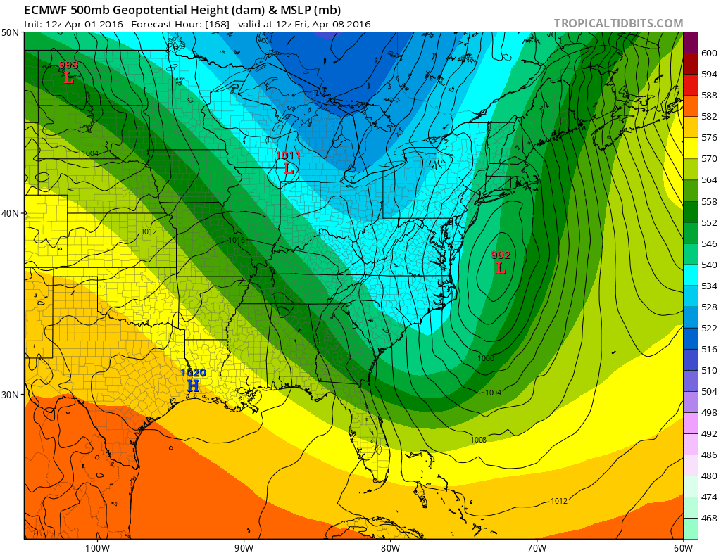
Then from here we have the Euro model and the Canadian model pointing to a nor’easter of some sort toward the end of next week.
Crazy Weather Week Ahead Euro Model Friday April 8, 2016
Now with regards to Monday into Tuesday morning, today’s models are coming in faster with moisture. If precipitation arrives during the day on Monday it might be wet snow and rain mixed but even if it were all snow, it is not going to stick until after dark. So timing here is everything and right now, even if it winds up being all wet snow, it is hard to see us getting much from this next system. It seems the colder and furthest south European would suggest a mix or even rain that changes to wet snow Monday night before ending.
Clearly the pattern is dynamic and offers tremendous volatility over the next week to 10 days so enjoy the ride with this Crazy Weather Week Ahead
FiOS1 News Weather Forecast For Long Island
FiOS1 News Weather Forecast For New Jersey
FiOS1 News Weather Forecast For Hudson Valley
NATIONAL WEATHER SERVICE SNOW FORECASTS
LATEST JOESTRADAMUS ON THE LONG RANGE

NOMINATED FOR AN APPY AWARD FOR BEST WEATHER APP!!
Weather App

Don’t be without Meteorologist Joe Cioffi’s weather app. It is really a meteorologist app because you get my forecasts and my analysis and not some automated computer generated forecast based on the GFS model. This is why your app forecast changes every 6 hours. It is model driven with no human input at all. It gives you an icon, a temperature and no insight whatsoever.
It is a complete weather app to suit your forecast needs. All the weather information you need is right on your phone. Android or I-phone, use it to keep track of all the latest weather information and forecasts. This weather app is also free of advertising so you don’t have to worry about security issues with your device. An accurate forecast and no worries that your device is being compromised.
Use it in conjunction with my website and my facebook and twitter and you have complete weather coverage of all the latest weather and the long range outlook. The website has been redone and upgraded. Its easy to use and everything is archived so you can see how well Joe does or doesn’t do when it comes to forecasts and outlooks.
Just click on the google play button or the apple store button on the sidebar for my app which is on My Weather Concierge. Download the app for free. Subscribe to my forecasts on an ad free environment for just 99 cents a month.
Get my forecasts in the palm of your hand for less than the cost of a cup of Joe!
![]()

