
Colder Air Continues to Arrive Gusty Winds Continue into Saturday
Chance of Snow Sunday Night into Monday

Colder Air Continues to Arrive Gusty Winds Continue into Saturday
Chance of Snow Sunday Night into Monday
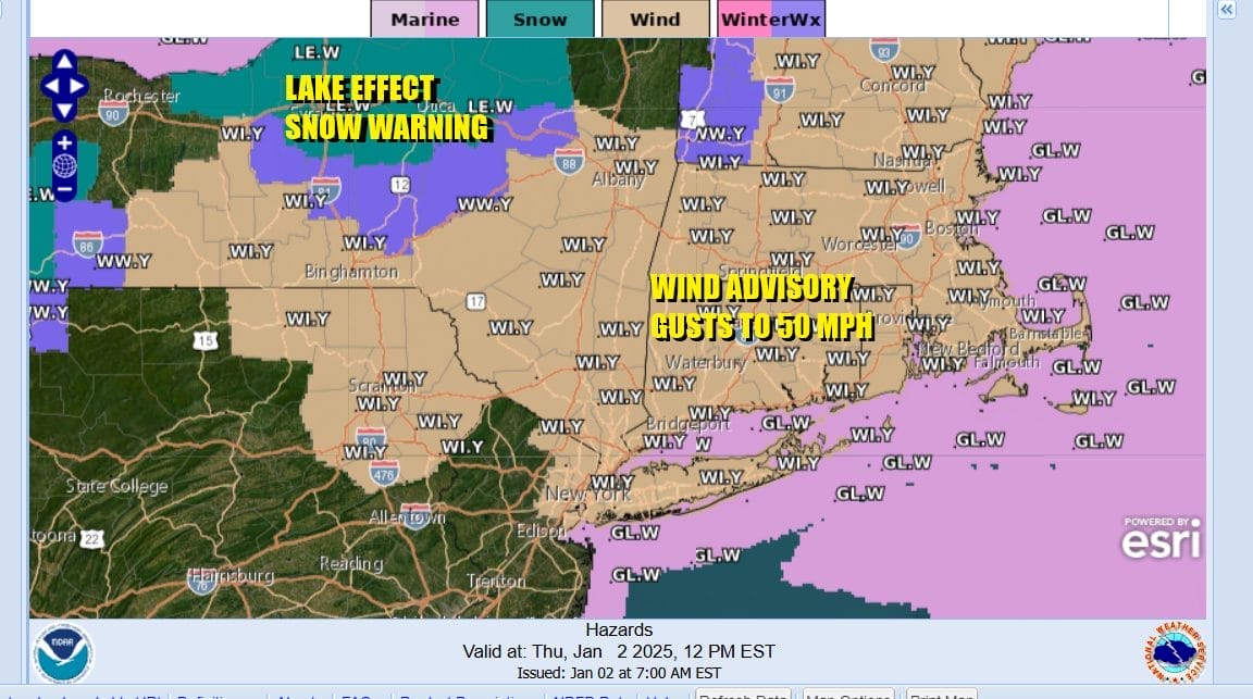
We continue to be under the influence of a large surface and upper air storm system in Atlantic Canada and that has revved up winds across the Northeast. Wind Advisories are in effect from Northern New Jersey through Upstate New York and New England. Winds will be gusting to 50 mph at times again today. Just out side of the advisory area you can expect winds to gust to 30 to 40 mph at times. All of this comes with a mix of sun and clouds. We have a series of upper troughs moving around the Atlantic Canada low and that will possibly set off some scattered snow showers this afternoon and evening.

Progressively colder air will be coming down today on northwest winds and temperatures this afternoon will probably top out in the upper 30s to around or just over 40 degrees in some places. Tonight skies should at least partially clear with morning lows across Eastern Pennsylvania to Southern New England mostly in the 20s. Satellite and radar loops are picking up on streamers of clouds and snow showers inland heading generally to the southeast.
SATELLITE WITH LIGHTNING STRIKES

WEATHER RADAR

Friday sees a slightly stronger short wave trough that will be moving east through the Mid Atlantic states. This could produce some snow showers across Southern Pennsylvania, Southern New Jersey, Maryland and Delaware and there even a chance of a heavier snow squall that whitens the ground in that region.
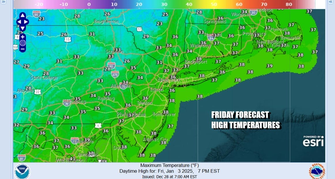
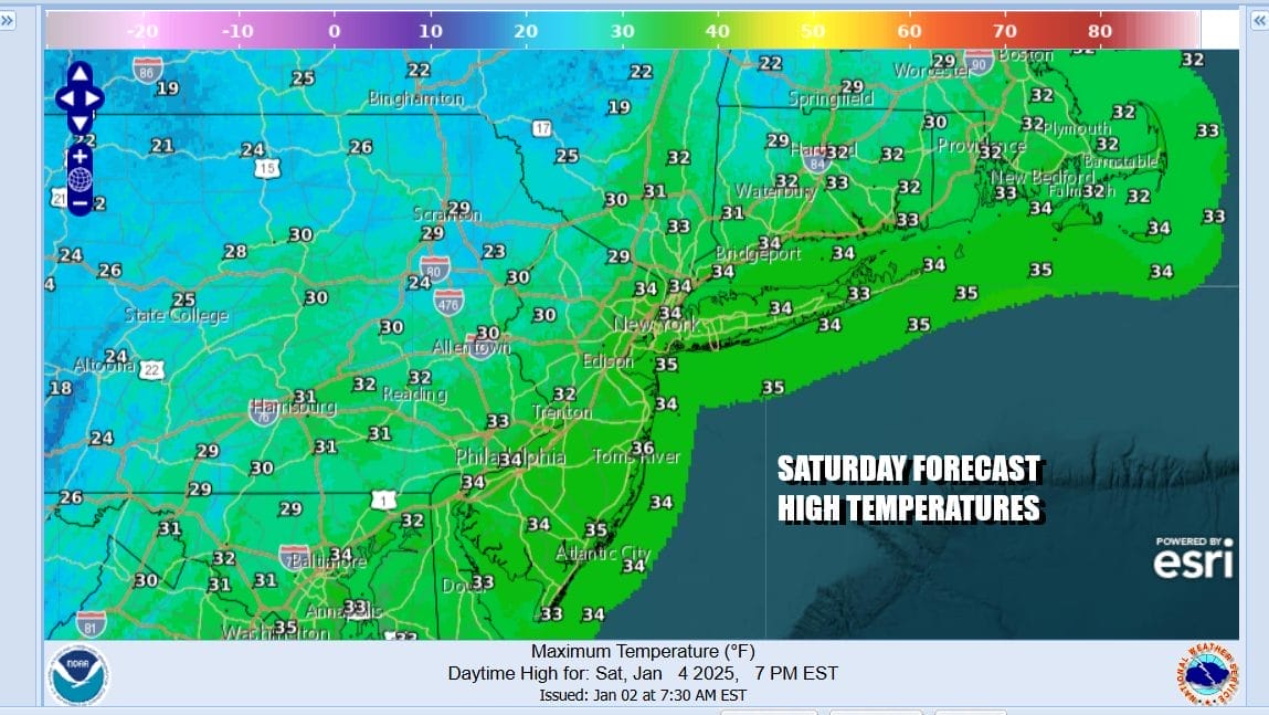
Friday across Eastern Pennsylvania to Southern New England will again be a little colder with no worse than partly sunny skies. We will throw in the chance for a scattered snow shower just in case something sneaks in. Temperatures Friday will generally top out in the mid to upper 30s. Once that trough passes east, colder air builds for Saturday which should be a partly to mostly sunny day. Winds are going to remain strong and gusty right into the weekend.
Our attention Sunday turns to low pressure that comes into the Western US Friday and then drops southeastward from the Rockies to the Southern Plains. We have a blocking low Over Atlantic Canada and this prevents the low from taking a track to the Great Lakes so it is forced to track eastward across the Lower Ohio/Upper Tennessee Valley Sunday and then east through Virginia/North Carolina Sunday night and Monday.

This system is likely to produce a swath of heavy snow (6 inches or more) across Missouri, Southern Illinois and Southern Indiana, Northern Kentucky, West Virginia, Virginia, Maryland and Delaware. The issue for areas further north from New Jersey to Southern New England is that the blocking low to the Northeast in Atlantic Canada prevents this low from turning more northward when it reaches the coast. Therefore there will be a sharp northern cutoff of the heavier snowfall.
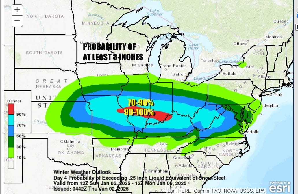
The Weather Prediction Center or WPC is forecasting high probabilities of at least 3 inches of snow just to the north of the surface low track for Sunday and Sunday night. Monday morning the low moves offshore and because of the large storm to the northeast, it tends to weaken and not strengthen. Monday WPC shows a 10 to 30 percent chance extending as far north as NYC and Western Long Island.

Since we are now entering the short term forecast range we will be carefully monitoring weather model guidance today to see if the trend of a strong blocking signature continues through the weekend or dues it relax enough to allow accumulating snow to track further north into southern areas of the Northeast and Northern Mid Atlantic. This is a snow or nothing situation as the atmosphere is cold enough to support all snow and not rain even in normally warmer coastal areas. Longer range it remains cold all of next week.
BE SURE TO DOWNLOAD THE FREE METEOROLOGIST JOE CIOFFI WEATHER APP &
ANGRY BEN’S FREE WEATHER APP “THE ANGRY WEATHERMAN!
MANY THANKS TO TROPICAL TIDBITS FOR THE USE OF MAPS
Please note that with regards to any severe weather, tropical storms, or hurricanes, should a storm be threatening, please consult your local National Weather Service office or your local government officials about what action you should be taking to protect life and property.


