Cold Weekend Rain Sunday Night into Early Monday
Followed By More Cold Weather

Cold Weekend Rain Sunday Night into Early Monday
Followed By More Cold Weather

Colder air arrived overnight and took temperatures down into the 20s just about everywhere for the lows. We are in the middle of cold high pressure building into the Mid Atlantic states today and it will be a day of lots of sunshine but high temperatures, which normally should be up around 50 or in the low 50s this time of year, will not get much above the upper 30s to lower 40s for highs.

This is going to lead us to a cold night under clear skies and light winds. There will be a spread in temperatures by morning. Inland lows will be in the 20s and warmer urban locations will bottom in the lower 30s. However some places that have radiational cooling on nights like tonight will see their lows down in the teens Sunday morning.
SATELLITE WITH LIGHTNING STRIKES

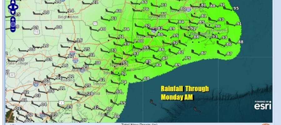
WEATHER RADAR

Sunday will be a day of sunshine giving way to arriving clouds. Low pressure and a cold front will be moving across the Eastern Great Lakes while a low develops along the Mid Atlantic coast and heads northeast. The front will enhance the low as it goes by Sunday evening and we will see showers or an area of rain move in from west to east Sundy evening. The rains should be gone by Monday morning.

After the cold start Sunday morning, temperatures Sunday afternoon will climb into and through the 40s and the cold air retreats. We probably won’t see much in the way of temperature changes overnight in the rain as we will still be in the 40s. Rainfall amounts will probably be a quarter of an inch or less inland while from NYC east and northeast 1/2 to 3/4 inches of rain is possible.

Next week will be dry all week long and it will be cold at least into Thursday. Monday we will see sunshine developing with highs in the 40s to around 50 degrees but colder air will bleed into the area from north to south and temperatures by Tuesday morning will be in the 20s. Tuesday and Wednesday we will see sunshine both days but highs will be in the upper 30s to lower 40s at best for highs and nights will be cold with lows in the 20s, teens in cold spots. An upper trough will be moving through Tuesday afternoon and evening and there could be some scattered snow showers when that trough goes by. Otherwise dry weather will be with us all week long. Thursday we will be back into the 40s for highs and Friday we could see mid to upper 40s. No major storms are in sight at this time.
BE SURE TO DOWNLOAD THE FREE METEOROLOGIST JOE CIOFFI WEATHER APP &
ANGRY BEN’S FREE WEATHER APP “THE ANGRY WEATHERMAN!
MANY THANKS TO TROPICAL TIDBITS FOR THE USE OF MAPS
Please note that with regards to any severe weather, tropical storms, or hurricanes, should a storm be threatening, please consult your local National Weather Service office or your local government officials about what action you should be taking to protect life and property.
(Amazon is an affilate of Meteorologist Joe Cioffi & earns commissions on sales.)


