
Cold Wednesday Snow Rain Thursday
Cold Wednesday Snow Rain Thursday
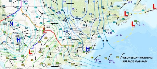
This morning is a great example of a surface map that is being impacted by blocking and a negative North Atlantic Oscillation index which we have spoken about many times. Low pressure to the northeast is moving very slowly east and this high pressure cell has taken almost 4 days to build in keeping temperatures well below normal. An air mass and setup like this a month from now and it could be quite the early winter!
This morning on the satellite loop you can see clouds are still a bit away to the west so we should have plenty of sun. Temperatures however will have a tough time with highs just into the 50s and some areas not getting out of the upper 40s.


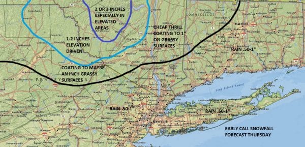
Low pressure comes in late tonight and Thursday and that cold high is going to be stubborn to get out of the way. Look for a burst of snow north and west of the coast moving in around daybreak. It ultimately changes to rain but there could be a slushy accumulation in some areas. I made no changes yet in the snowfall forecast map even though models were a tad faster and colder with the onset of precipitation. In the end it doesn’t matter since it changes to rain and we are only talking about at most a couple of hours of snow and sleet.
JOE’S SNOW FORECAST THURSDAY
Once this weather system goes by weather conditions improve for the weekend. Other than a weak cold front that comes through Saturday evening, there are no weather issues through Sunday.
MANY THANKS TO TROPICAL TIDBITS FOR THE WONDERFUL USE OF THE MAPS
SNOW REMOVAL COMPANIES FOR YOUR WINTER NEEDS
LONG ISLAND ROCKLAND COUNTY Connecticut

![]()

WINTER WEATHER OUTLOOK VIDEOS
In case you missed them I’ve been previewing the upcoming winter in a series of posts and videos. Here are the first 2. More will be coming along. Links to the latest posts are below.
NEW JERSEY
LONG ISLAND AND NEARBY
WINTER 2016-2017 PART 3 NEW JERSEY
WINTER 2016-2017 PART 1 OCEAN WATER TEMPERATURES
WINTER 2016-2017 PART 2 ARCTIC SEA ICE AND SIBERIAN SNOW COVER
FiOS1 News Weather Forecast For Long Island
FiOS1 News Weather Forecast For New Jersey
FiOS1 News Weather Forecast For Hudson Valley
NATIONAL WEATHER SERVICE SNOW FORECASTS
LATEST JOESTRADAMUS ON THE LONG RANGE

Weather App

Don’t be without Meteorologist Joe Cioffi’s weather app. It is really a meteorologist app because you get my forecasts and my analysis and not some automated computer generated forecast based on the GFS model. This is why your app forecast changes every 6 hours. It is model driven with no human input at all. It gives you an icon, a temperature and no insight whatsoever.
It is a complete weather app to suit your forecast needs. All the weather information you need is right on your phone. Android or I-phone, use it to keep track of all the latest weather information and forecasts. This weather app is also free of advertising so you don’t have to worry about security issues with your device. An accurate forecast and no worries that your device is being compromised.
Use it in conjunction with my website and my facebook and twitter and you have complete weather coverage of all the latest weather and the long range outlook. The website has been redone and upgraded. Its easy to use and everything is archived so you can see how well Joe does or doesn’t do when it comes to forecasts and outlooks.
Just click on the google play button or the apple store button on the sidebar for my app which is on My Weather Concierge. Download the app for free. Subscribe to my forecasts on an ad free environment for just 99 cents a month.
Get my forecasts in the palm of your hand for less than the cost of a cup of Joe!


