Cold Temperatures Weekend Then Back to 60
Cold Temperatures Weekend Then Back to 60
Once this cold front moves through tonight we begin a stair step decline into the weekend where temperatures (for a change) will be running 10-15 degrees below average. It will be short lived cold because once we get to Sunday afternoon temperatures will start to rebound and then it is back to 60s on Tuesday of next week with the next strong cold front and the threat for showers and thunderstorms. Such is the volatile weather world we live in at the moment.
Satellite loop shows clouds from the cold front to our west. The front will move through a little after midnight and there could be anouther shower or two passing through with that. The marine layer effectively killed all the severe weather for areas from Northern New Jersey to NYC and points north and east. Even south and west of there we saw a few briefly severe cells before those weakened and moved to the east.
SATELLITE LOOP

REGIONAL RADAR

LOCAL RADAR NEW YORK CITY

LOCAL RADAR PHILADELPHIA


Skies will clear out late tonight and it will become windy with Wind Advisories posted overnight and on Thursday for westerly winds gusting to 40 mph or more. Thursday we will see a mix of sun and clouds with temperatures holding in the 40s. Friday will be colder with temperatures in the upper 30s and lower 40s with some sun and clouds. Low pressure to the south passes east and offshore with no snow in the forecast. Then temperatures head down into the teens to near 20 Saturday and Sunday morning with Saturday’s highs just in the 30s.
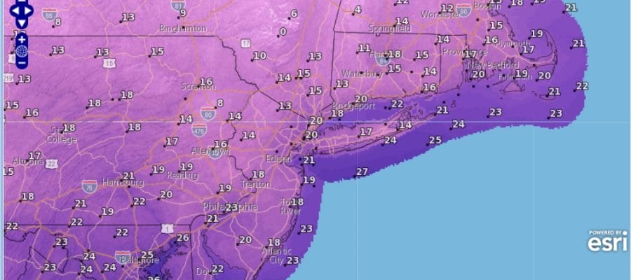
SATURDAY MORNING COLD FORECAST LOWS

SUNDAY MORNING COLD FORECAST LOWS

Sunday we will see clouds and some breaks of sun as warmer air tries to arrive. We should be back into the 40s. Then Monday we will be in the 50s with the next chance for showers and thunderstorms on Tuesday with highs in the 60s again.
 GET JOE A CIGAR IF YOU LIKE

SNOW REMOVAL COMPANIES FOR YOUR WINTER NEEDS
LONG ISLAND ROCKLAND COUNTY Connecticut

![]()

ROCKLAND COUNTY TRI STATE SNOW REMOVAL JOHNSTOWN PA


FiOS1 News Weather Forecast For Long Island
FiOS1 News Weather Forecast For New Jersey
FiOS1 News Weather Forecast For Hudson Valley
NATIONAL WEATHER SERVICE SNOW FORECASTS
LATEST JOESTRADAMUS ON THE LONG RANGE
Weather App

Don’t be without Meteorologist Joe Cioffi’s weather app. It is really a meteorologist app because you get my forecasts and my analysis and not some automated computer generated forecast based on the GFS model. This is why your app forecast changes every 6 hours. It is model driven with no human input at all. It gives you an icon, a temperature and no insight whatsoever.
It is a complete weather app to suit your forecast needs. All the weather information you need is right on your phone. Android or I-phone, use it to keep track of all the latest weather information and forecasts. This weather app is also free of advertising so you don’t have to worry about security issues with your device. An accurate forecast and no worries that your device is being compromised.
Use it in conjunction with my website and my facebook and twitter and you have complete weather coverage of all the latest weather and the long range outlook. The website has been redone and upgraded. Its easy to use and everything is archived so you can see how well Joe does or doesn’t do when it comes to forecasts and outlooks.
Just click on the google play button or the apple store button on the sidebar for my app which is on My Weather Concierge. Download the app for free. Subscribe to my forecasts on an ad free environment for just 99 cents a month.
Get my forecasts in the palm of your hand for less than the cost of a cup of Joe!


