Cold Saturday Temperatures Moderate Sunday
Chance Rain Snow Showers White Christmas Outlook

Weather in 5/Joe & Joe Weather Show Latest Podcast
Cold Saturday Temperatures Moderate Sunday
Chance Rain Snow Showers White Christmas Outlook
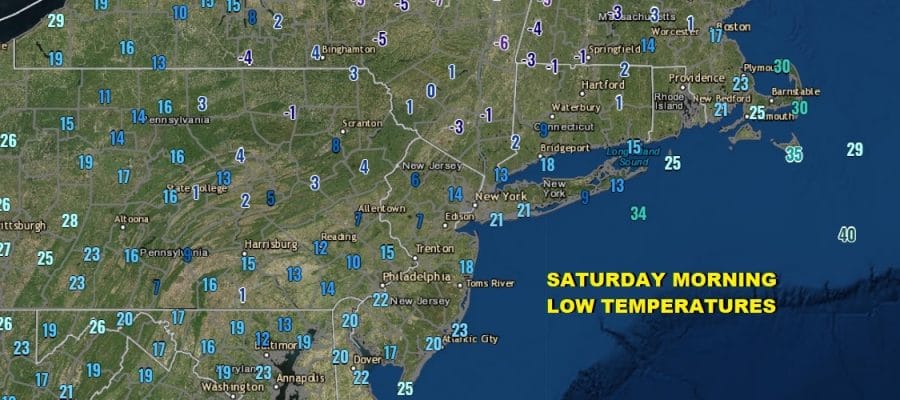
The core of the cold air mass was directly overhead last night and this morning and this sent temperatures plummeting to the lowest of the season. A nice deep snow cover helped the cause and we saw lows in many inland areas in the single digits and even below zero in some places.

We should see some temperature recovery today though that may be hampered by high clouds that are overhead on the satellite picture. Still there should be enough veiled sunshine to take temperatures up into the low and middle 30s in most places.
SATELLITE

There are no issues today to deal with on the radars which remain unavailable on the National Weather Service website as they debut a new interactive radar. Thankfully there are no major storms on the horizon this weekend or early next week. High clouds will be around tonight with lows in the upper teens to mid 20s.

Sunday sees a weak front and wave developing on it but there isn’t much for this system to work on. Look for lots of clouds Sunday with the chance for a few passing rain or snow showers in the afternoon. Highs will be in the 30s to near 40 in some places.

Monday brings a northern jet stream feature into the mix and since the two streams are separate this system will be weak as well with a few rain or snow showers late Monday afternoon and evening. Monday’s highs will be in the upper 30s and lower 40s. A cold shot of dry air comes in for Tuesday with highs in the low to mid 30s. We will start to warm up into the 40s Wednesday though it should still be dry.

The rumor mill is churning about Christmas Eve and Christmas Day. We have a sharp cold front that is going to approaching. You can tell it is sharp the the V shaped isobars. These types of systems usually produce some heavy showers ahead of it and then a sharp shift in the wind direction from southwest to northwest. Then a sharp drop in temperatures follow. Such is the case here Thursday Christmas Eve will be cloudy with rain showers developing and becoming heavy at times in the Thursday evening. Highs will be in the 50s. Then the front passes and the precipitation ends. Usually in cases like this we see the rain ending with no change over to snow and that is the way we will play it. Friday Christmas Day will be windy and very cold with temperatures probably settling into the upper 20s to middle 30s. Next weekend looks dry and cold.
BE SURE TO DOWNLOAD THE FREE METEOROLOGIST JOE CIOFFI WEATHER APP &
ANGRY BEN’S FREE WEATHER APP “THE ANGRY WEATHERMAN!
MANY THANKS TO TROPICAL TIDBITS FOR THE USE OF MAPS
Please note that with regards to any severe weather, tropical storms, or hurricanes, should a storm be threatening, please consult your local National Weather Service office or your local government officials about what action you should be taking to protect life and property.


