Cold Front Stalls With Rain Tonight & Thursday But Nothing Major,
Easter Weekend Outlook

Cold Front Stalls With Rain Tonight & Thursday But Nothing Major,
Easter Weekend Outlook

A cold front is stalling overhead today in a north-northeast, south-southwest fashion from Maine to the Carolinas. The onshore flow has shifted from one with a northeast wind to one with a southeast wind taking over from coast to inland areas. Now we wait for a wave to develop on this front later today and tonight. This leaves us in a cloudy place today. Most highs will be in the 50s except for areas right near the coast. South and east facing shorelines will see highs in the 40s. I don’t expect to see much rain during the day to day other than the odd sprinkle or shower.
SATELLITE WITH LIGHTNING STRIKES

WEATHER RADAR

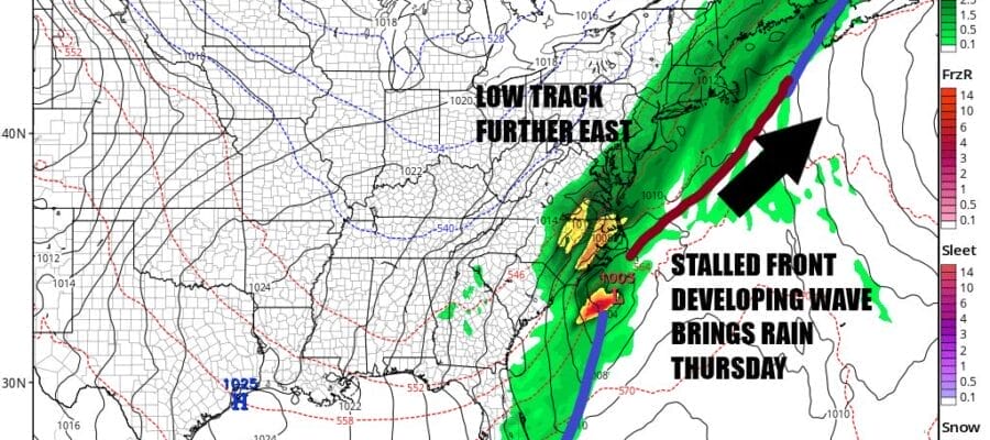
Satellite and radar loops are showing rain and some thunderstorms developing across the Southeast US and low pressure develops along the South Carolina coast. The stalled front is basically the runway for the low to move along. We were thinking earlier this week that this low will tend to move more to the east once it reaches North Carolina rather than north and that this would reduce the risk of another extreme heavy rainfall.

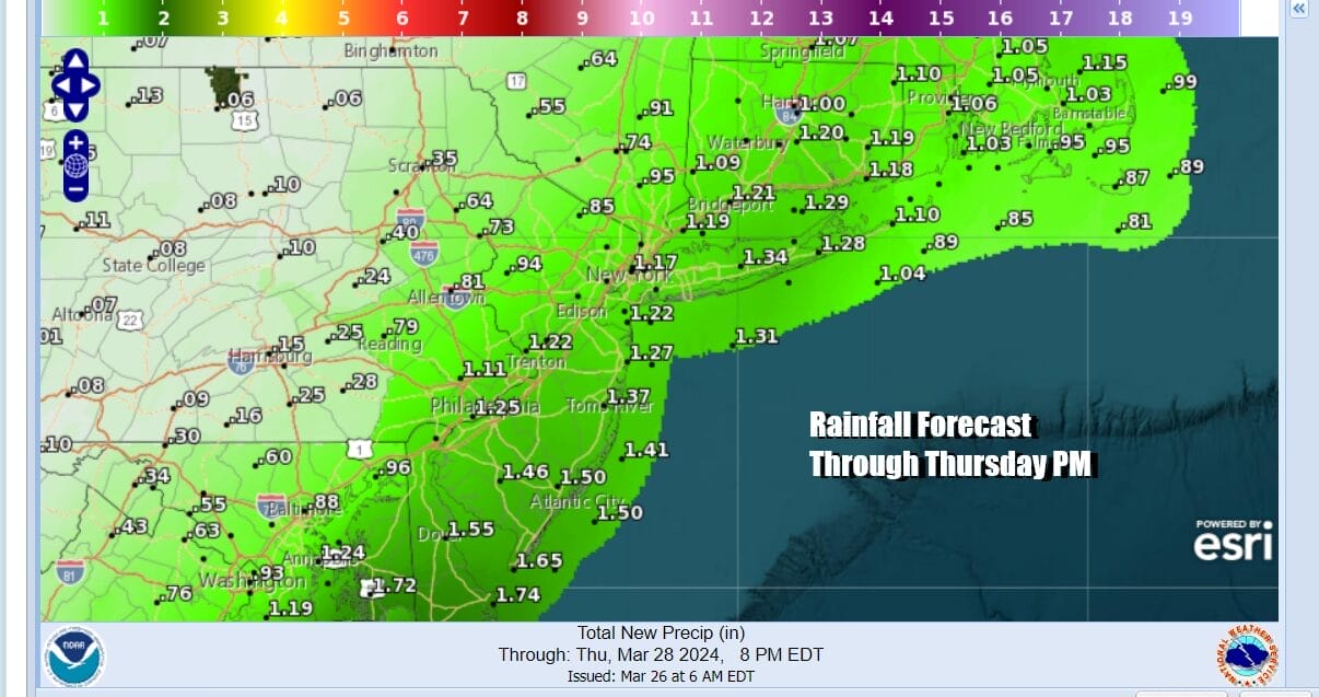
After a couple of model runs where the we saw some wobbling westward, we have settled on a slightly flatter northeast track. Rainfall amounts will probably total 3/4 inch to 1.25 inches in most places with the heaviest rain from Coastal New Jersey to Long Island to Southeastern New England and much less as you head to Western New Jersey and the Hudson Valley northwest of Route 84.
Look for rain to develop from south to north tonight and it will continue for much of the day Thursday. Highs Thursday will be in the 50s. The low moves out and the rain ends from west to east late Thursday aftenroon and evening and skies will partially clear out Thursday night. Friday looks like a nice day with some sunshine and breezy conditions with highs into the 50s. As far as the weekend goes we see a weak system moving southeast from the Great Lakes Saturday. This will likely produced clouds. There could be a couple of showers from Southern Pennsylvania and Southern New Jersey southward. Highs will be in the 50s. Easter Sunday looks like a nice day of sunshine and highs again in the 50s.
BE SURE TO DOWNLOAD THE FREE METEOROLOGIST JOE CIOFFI WEATHER APP &
ANGRY BEN’S FREE WEATHER APP “THE ANGRY WEATHERMAN!
MANY THANKS TO TROPICAL TIDBITS FOR THE USE OF MAPS
Please note that with regards to any severe weather, tropical storms, or hurricanes, should a storm be threatening, please consult your local National Weather Service office or your local government officials about what action you should be taking to protect life and property.
(Amazon is an affilate of Meteorologist Joe Cioffi & earns commissions on sales.)


