CHILLY AIR ARRIVES ON GUSTY NORTHWEST WINDS TODAY
TEMPERATURES 10 DEGREES OR MORE BELOW AVERAGE INTO THE WEEKEND
COASTAL STORM PLAYS THROUGH FRIDAY NIGHT SATURDAY IMPROVES SUNDAY
This morning we have a developing storm in the Gulf of Maine that is bringing winter weather to Northern New England and it is pulling down cold air into the Northeast & Middle Atlantic States. We are seeing some sunshine this morning but we are likely to see some instability clouds develop at times today especially to the east as that storm spins around today. Temperatures made their rebound run yesterday into the 60s but that is now done and today’s highs will be just in the low to mid 50s. Winds from the northwest will gust around 20 to 30 mph at times making it feel even colder.
EASTERN SATELLITE

REGIONAL RADAR

Tonight we will see temperatures drop on a north northwest wind and clear skies. Temperatures Thursday morning will in the 30s with 20s in the cold spots. Thursday we will see plenty of sunshine with highs just in the upper 40s to lower 50s and lows Friday morning will be in the upper 20s to middle 30s. Friday we will see sunshine giving way to arriving clouds with highs in the upper 40s to around 50 as we watch low pressure cross the Gulf States and make the left turn up the East Coast.
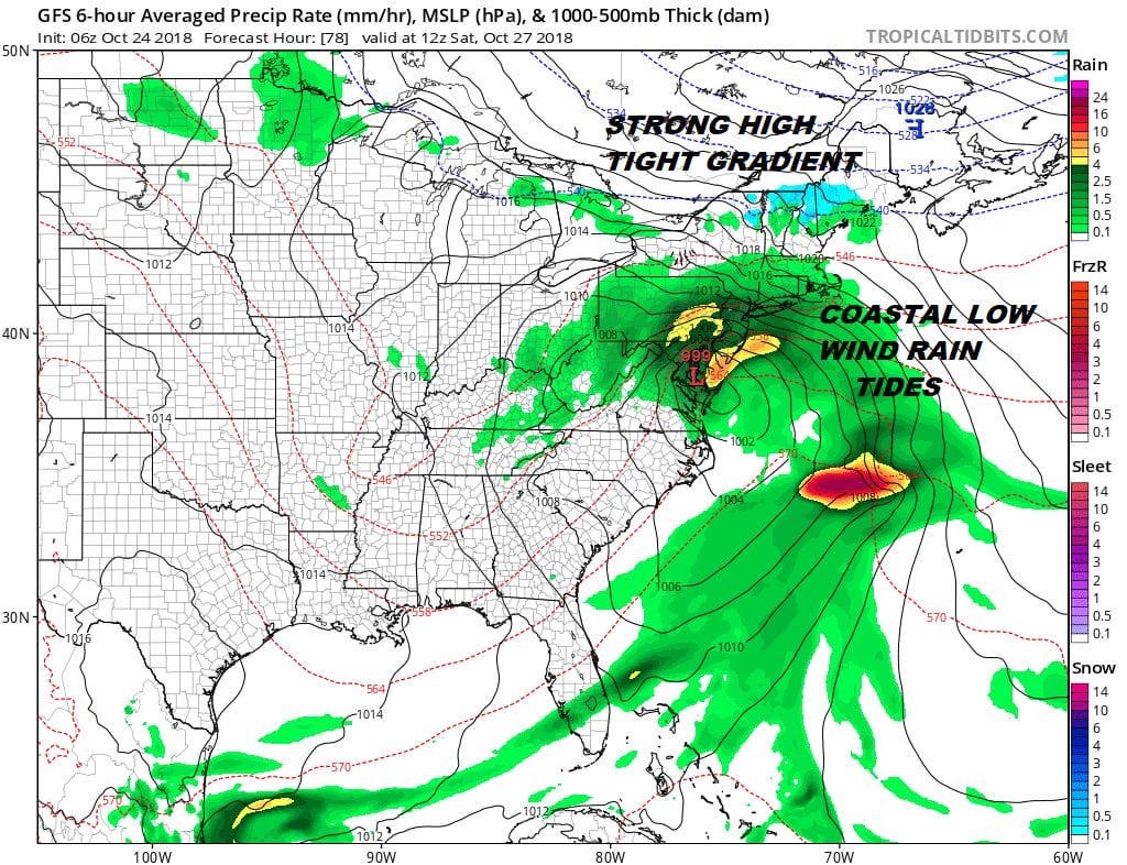
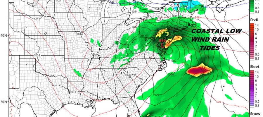
It looks like the rain spreads up the coast faster and comes in during Friday evening from south to north. This will likely mean that it moves out faster and the rain begins to wind down Saturday afternoon and evening. This looks to bring strong gusty winds along the immediate coast, some heavier rain, and perhaps 1 tide cycle where coastal flooding could be an issue. If this plays out according to plan the low lifts out to the north Saturday night and weather conditions improve on Sunday. Saturday temperatures while all this is going on will be in the raw 40s but we should be back into the 50s on Sunday particularly if weather conditions improve. While we think Saturday will be a rather ugly day it should be manageable for the most part.
SUBSCRIBE TO PATREON FOR A WEATHER EXPERIENCE FREE OF ADS, EXCLUSIVE VIDEOS FOR MEMBERS ONLY AND MUCH MORE…STARTS AT $2 A MONTH..MESSAGE ME AT ANY TIME

MANY THANKS TO TROPICAL TIDBITS FOR THE USE OF MAPS
Please note that with regards to any tropical storms or hurricanes, should a storm be threatening, please consult your local National Weather Service office or your local government officials about what action you should be taking to protect life and property.
LATEST JOESTRADAMUS ON THE LONG RANGE

