
Clouds Rain Heading Our Way
![]()
We are having a pleasant night with just some high clouds. The dry air over upstate New York and New England is helping to initially suppress the southern moisture that is lifted northward out of the Gulf of Mexico. This should keep things dry into Sunday morning and after morning lows in the 30s to low 40s we should see highs Sunday in the 50s. Sunshine will give way to arriving clouds on Sunday from south to north. It will cloud up quickly in southern areas however the dry air might hold the clouds off until midday. Gradually northern areas will turn overcast later on Sunday.
Clouds Rain Heading Our Way Satellite Loop

Clouds Rain Heading Our Way Regional Radar

Clouds Rain Heading Our Way Local Radar Loops


Radars tonight remain quiet however we should begin to see some rain appear later Sunday and it could be into Southern New Jersey and Southern Pennsylvania later Sunday afternoon but it will be on the light and spotty side. The bulk of the rain will hold off until late Sunday night or first thing Monday morning. Even though the rain holds off the onshore flow will increase later Sunday and Sunday night and low clouds and drizzle are possible before the main area of rain arrives.
NAM MODEL RAINFALL FORECAST
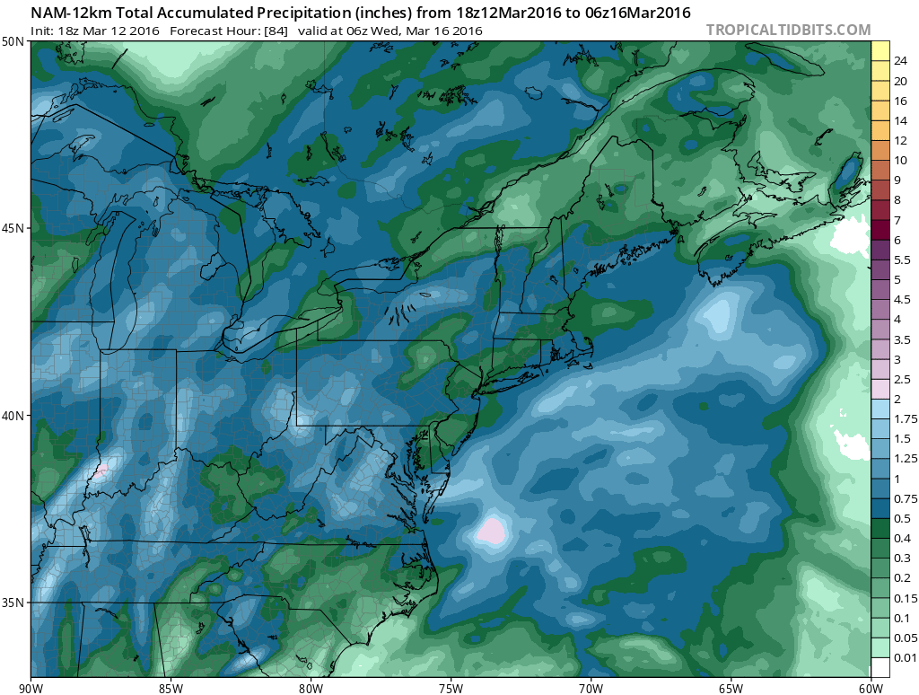
Rainfall will be spread over 2 days with amounts of half an inch to an inch. The first batch of rain moves out late Monday and Monday evening with a second area coming in early on Tuesday. Low clouds will be difficult to dislodge until the east wind relaxes. Temperatures Monday and much of Tuesday will struggle in the 40s.
FiOS1 News Weather Forecast For Long Island
FiOS1 News Weather Forecast For New Jersey
FiOS1 News Weather Forecast For Hudson Valley
NATIONAL WEATHER SERVICE SNOW FORECASTS
LATEST JOESTRADAMUS ON THE LONG RANGE
Weather App

Don’t be without Meteorologist Joe Cioffi’s weather app. It is really a meteorologist app because you get my forecasts and my analysis and not some automated computer generated forecast based on the GFS model. This is why your app forecast changes every 6 hours. It is model driven with no human input at all. It gives you an icon, a temperature and no insight whatsoever.
It is a complete weather app to suit your forecast needs. All the weather information you need is right on your phone. Android or I-phone, use it to keep track of all the latest weather information and forecasts. This weather app is also free of advertising so you don’t have to worry about security issues with your device. An accurate forecast and no worries that your device is being compromised.
Use it in conjunction with my website and my facebook and twitter and you have complete weather coverage of all the latest weather and the long range outlook. The website has been redone and upgraded. Its easy to use and everything is archived so you can see how well Joe does or doesn’t do when it comes to forecasts and outlooks.
Just click on the google play button or the apple store button on the sidebar for my app which is on My Weather Concierge. Download the app for free. Subscribe to my forecasts on an ad free environment for just 99 cents a month.
Get my forecasts in the palm of your hand for less than the cost of a cup of Joe!
![]()
![]()
<


