Clouds Linger Today Dry Monday Front Tuesday
SHOP THE JOESTRADAMUS STORE
Clouds Linger Today Dry Monday Front Tuesday
An upper air disturbance is moving through this morning as we are dealing with clouds. To the south over the Delmarva Peninsula we are actually seeing a few showers this morning but those showers are moving to the east southeast and they will not be a problem for us. Sunshine should be able to pierce through the clouds in some places and highs should reach into the lower 50s in most places. The satellite loop also shows the beginnings of the next cold front developing in the Northern Rockies that will set the ball rolling to colder weather later this week. That front arrives here Wednesday morning.
SATELLITE LOOP

REGIONAL RADAR

Monday will be a nice day with sunshine and the 12th day in a row without any significant rainfall. Highs Monday will be in into the 50s again. Tuesday the cold front approaches and we will see cloudy skies with a few showers followed by more numerous showers Tuesday night into Wednesday morning. Tuesday will be warm with highs in the 50s to near 60.
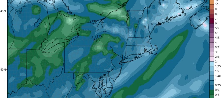
GFS RAINFALL FORECAST ENDING WEDNESDAY EVENING

This front should be able to produce some local amounts up to an inch or so of rain which will help put a dent in the dry conditions we have been experiencing since the autumn began. Once the front passes Wednesday morning temperatures fall from near 60 to the 40s until we hit bottom Thursday morning in the 20s to near 30 with highs Thursday in the upper 30s to lower 40s.
The first question once the colder air arrives is whether there will be any snow. Weather models show the front stalling offshore and a wave developing on the front will move northeastward. This makes for a tough call on Friday as the wave passes offshore but will it be close enough to produce precipitation?
GFS MODEL FORECAST FRIDAY THROUGH SUNDAY CLICK TO ANIMATE
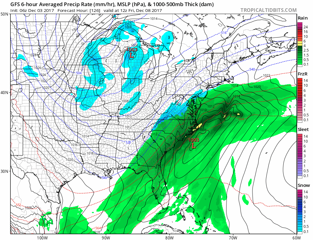
In addition this is complicated by a diving upper air system into the Ohio Valley. This could energize the wave offshore and make it stronger or remain a completely separate feature as it swings eastward later in the weekend. Weather models may start to come closer to some sort of consensus in the next day or 2. It would seem somebody is going to see the first snows next weekend from the interior Middle Atlantic northward into New England. Longer term the weather pattern in general looks cold for the next 10 days at least as we continue to see the flow of air from Northern Canada bringing cold air masses into the Eastern US.
 GET JOE A CIGAR IF YOU LIKE

FiOS1 News Weather Forecast For Long Island
FiOS1 News Weather Forecast For New Jersey
FiOS1 News Weather Forecast For Hudson Valley


