Clouds Building Moving North

Clouds Building Moving North
Rain For Southern Areas On Radar

The dry air that arrived yesterday is fighting the moisture field to the south as evidenced by the satellite loop above and the regional radar below. Areas from Central New Jersey northward into Southern New England are enjoying a good deal of sunshine but clouds are moving in across areas south of RT 195 and they are beginning to spread northeastward. Radar shows rain in a band moving across the Delmarva Peninsula and for the most part the band is sliding east with not much of a northward component at the moment.
Clouds Building Moving North
Regional Radar

Clouds Building Moving North
Local Radars


At some point some rain will sneak into Southeastern Pennsylvania and Southern New Jersey this evening and tonight but I’m not sure how far north this rain is going to get. The dry air to the north is pretty stubborn so some of that moisture will dry out. The clouds however will probably build northward tonight into Tuesday until this weak wave moves out to the southeast. Temperatures today are reaching the 70s where it is Sunday but they are staying in the 60s where there are more clouds.
Clouds Building Moving North
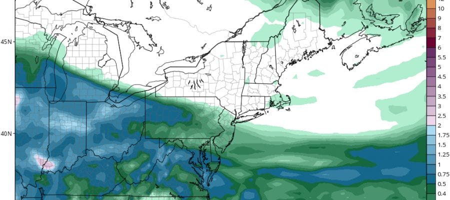
GFS RAINFALL FORECAST

Rainfall amounts if any will be light with amounts under .10 of an inch in most places. You have to go south into Delaware to find .25 inches of rain or more out of this.
Tonight where skies stay clear (mainly north and eastern areas of New York and Southern New England) there is a frost advisory posted. Otherwise most lows will be in the 40s to lower 50s. Tuesday’s highs will reach the 60s in most places. Watch for a passing shower from New York City Southward, and maybe a brief period of steady rain in Southern New Jersey and Southeastern Pennsylvania.
Wednesday looks better with sunshine and clouds with highs in the upper 60s and lower 70s. Thursday looks dry as well before showers arrive on Friday. No major rain events are on tap for this week.
FiOS1 News Weather Forecast For Long Island
FiOS1 News Weather Forecast For New Jersey
FiOS1 News Weather Forecast For Hudson Valley
NATIONAL WEATHER SERVICE SNOW FORECASTS
LATEST JOESTRADAMUS ON THE LONG RANGE
Weather App

Don’t be without Meteorologist Joe Cioffi’s weather app. It is really a meteorologist app because you get my forecasts and my analysis and not some automated computer generated forecast based on the GFS model. This is why your app forecast changes every 6 hours. It is model driven with no human input at all. It gives you an icon, a temperature and no insight whatsoever.
It is a complete weather app to suit your forecast needs. All the weather information you need is right on your phone. Android or I-phone, use it to keep track of all the latest weather information and forecasts. This weather app is also free of advertising so you don’t have to worry about security issues with your device. An accurate forecast and no worries that your device is being compromised.
Use it in conjunction with my website and my facebook and twitter and you have complete weather coverage of all the latest weather and the long range outlook. The website has been redone and upgraded. Its easy to use and everything is archived so you can see how well Joe does or doesn’t do when it comes to forecasts and outlooks.
Just click on the google play button or the apple store button on the sidebar for my app which is on My Weather Concierge. Download the app for free. Subscribe to my forecasts on an ad free environment for just 99 cents a month.
Get my forecasts in the palm of your hand for less than the cost of a cup of Joe!
![]()
![]()

MENTION JOE CIOFFI AND GET A 5% DISCOUNT


