

Closer Shave Thursday Night
Model runs this afternoon are indicating that while the storm that will be offshore is still offshore but it does make it a closer shave Thursday night for Coastal areas of New Jersey & Long Island. At this point it should be noted that even if the storm were further west, the precipitation would be light and could just well be rain since the atmosphere would be borderline. To me this does look like one of these situations where everything that is happening still winds up being too little too late. Still when the model show precipitation this close, it does tend to make one a little bit cautious.
Closer Shave Thursday Night UPPER AIR DIFFERENCES ON THE NAM
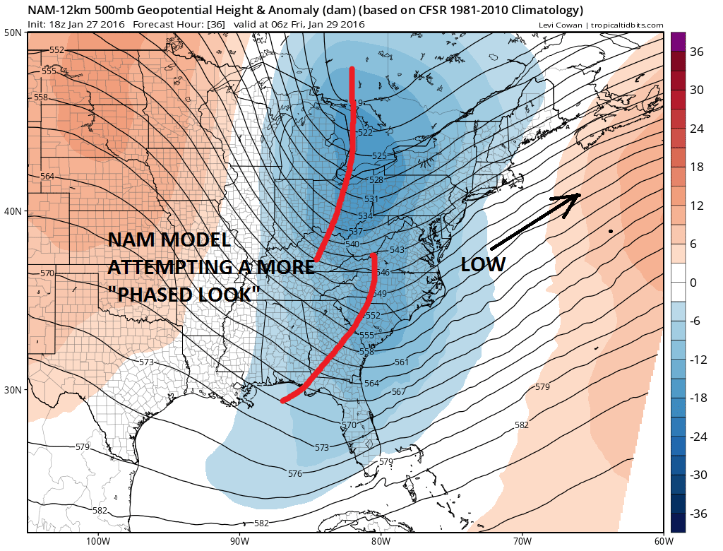
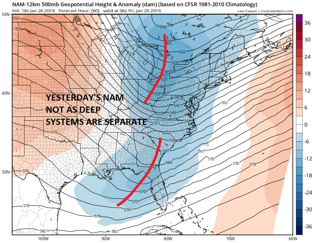
The differences between yesterday and today on the NAM model are twofold. First is that the troughs are distinctly separated and never phase in time. This afternoon’s run has a deeper more phased look to it. It handles the northern stream disturbance by showing it to me much deeper than 24 or even 12 hours ago. Still all this could be true and the outcome may still wind up being the same and that is a low far enough offshore not to cause any issues. However between the NAM’s performance on the Blizzard and also the tendency for models to come in westward at the last minute does give one pause. It should be noted that the NAM stands alone on this and no other model is as far west, though the GFS did trend slightly westward.
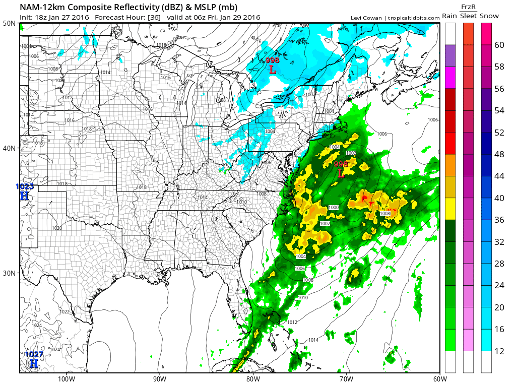
From a forecasting standpoint I will be predicting lots of clouds but for now I’m going to leave any mention of precipitation out of the forecast until somebody else joins this parade. It should be noted again that even if this were to be more tucked in, the worst case scenario would be a 6 hour period of rain or perhaps wet snow and only for the coast on Thursday night.
One note about the long range. The European model reloads the pattern after next week’s storm heads to the Great Lakes. See my JOESTRADAMUS post from last night.
LONG RANGE VIDEO ANALYSIS ATTACK OF THE POLAR VORTEX PART 2
NATIONAL WEATHER SERVICE SNOW FORECASTS
LATEST JOESTRADAMUS ON THE LONG RANGE
Weather App

Winter is here! Don’t be without Meteorologist Joe Cioffi’s weather app. It is a complete weather app to suit your forecast needs. All the weather information you need is right on your phone. Android or I-phone, use it to keep track of all the latest weather information and forecasts. This weather app is also free of advertising so you don’t have to worry about security issues with your device. An accurate forecast and no worries that your device is being compromised.
Use it in conjunction with my website and my facebook and twitterand you have complete weather coverage of all the latest weather and the long range outlook. The website has been redone and upgraded. Its easy to use and everything is archived so you can see how well Joe does or doesn’t do when it comes to forecasts and outlooks.
Just click on the google play button or the apple store button on the sidebar for my app which is onMy Weather Concierge. Download the app for free. Subscribe to my forecasts on an ad free environment for just 99 cents a month.
Get my forecasts in the palm of your hand for less than the cost of a cup of Joe!

![]()


