Christmas Eve Weather Improves, Warm Christmas Day
Rain Tuesday Night into Wednesday

Christmas Eve Weather Improves, Warm Christmas Day
Rain Tuesday Night into Wednesday
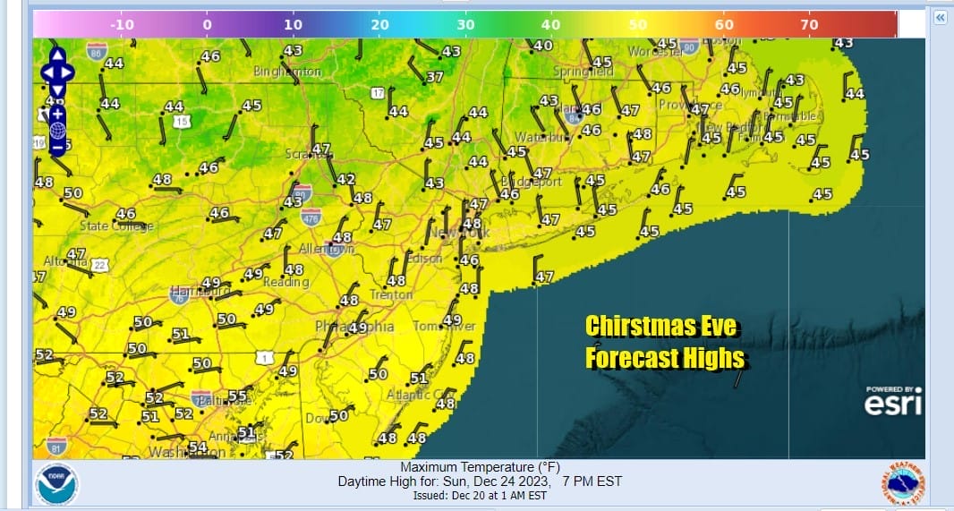
We do have some Winter Weather Advisories this morning in parts of the Hudson Valley and the Catskills for some light freezing rain especially in areas where cold air tends to get trapped. This advisory is up until 9am and then should be discontinued as temperatures warm up. Today, Christmas Eve sees a weather front draped from Lake Erie to the Saint Lawrence River leaving us in warmer air today. We also have lots of clouds around and overnight some showers played through. As we move through the course of the day we will see a mainly overcast day. There could be some brightening of skies or even a break or two of sun but the overall picture today will be one of clouds. We don’t expect any additional rain today other than the odd leftover brief shower. Highs today will range from the mid 40s in the Hudson Valley and Connecticut to upper 40s and lower 50s across Eastern Pennsylvania, New Jersey and points southward.
SATELLITE WITH LIGHTNING STRIKES

WEATHER RADAR

We don’t see any real issue tonight other than some clouds around. It will be a warm night with no precipitation issues and most lows will be in the 30s to near 40. Christmas Day will be a dry day with clouds and some sunshine. Highs will reach into the 50s in most places.

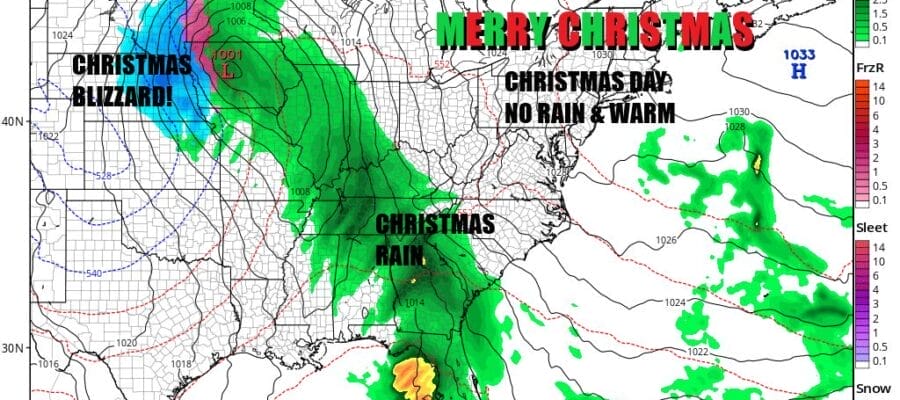
Menwhile we have a storm system that is developing today and spreading rain up and down the Mississippi Valley from Minnesota to Louisiana. The surface low is going to ride northward on the front and then swing northwestward into the Dakotas. In the meantime we will see snow and blizzard conditions in parts of Nebraska and South Dakota for the next few days.

The low itself isn’t coming east but the corresponding cold front is and it is doing so slower than advertised days ago. Tuesday will likely be a dry day with clouds around. Showers will proably stay well to the west during the day and only move slowly eastward Tuesday night. Temperatures will be in the warm low and middle 50s.

As the front swings toward the coast it passes off the Southeast Coast first where low pressure develops and heads northeast, spreading rain across Eastern Pennsylvania to Southern New England Wednesday and lasting into Thursday morning. Highs Wednesday will again be in the 50s. Rain should end Thursday morning and then it will be a slow drop to colder and more normal temperatures for Friday and next weekend. Enjoy your Christmas Eve and Christmas Day and we extend holiday good wishes to you and and your family. We will be taking a short break here today and Monday and we will be updating weather sometime Monday evening after the gifts have been opened and the food digested!
BE SURE TO DOWNLOAD THE FREE METEOROLOGIST JOE CIOFFI WEATHER APP &
ANGRY BEN’S FREE WEATHER APP “THE ANGRY WEATHERMAN!
MANY THANKS TO TROPICAL TIDBITS FOR THE USE OF MAPS
Please note that with regards to any severe weather, tropical storms, or hurricanes, should a storm be threatening, please consult your local National Weather Service office or your local government officials about what action you should be taking to protect life and property.
(Amazon is an affilate of Meteorologist Joe Cioffi & earns commissions on sales.)


