Merry Christmas Warm Day Rain Coming For Later Tuesday Night Wednesday

Merry Christmas Warm Day Rain Coming For Later Tuesday Night Wednesday

Merry Christmas to all on this wonderful day of celebration. Once again no white Christmas this year and it is opposite from last year when we were sitting in the middle of an Arctic air mass up and down the Eastern US. Today feels more like a mid fall or early spring day with a soupy start and then just going to a mostly cloudy to occasional partly sunny type of day. Most highs will be in the upper 40s to lower 50s. There are no rain issues today as high pressure holds off the East Coast and the the next storm system and cold front are still about a day or so away. So there are no weather related travel issues other than some patchy areas of fog this morning, mainly along the coast in in parts of Southern New England.
SATELLITE WITH LIGHTNING STRIKES

WEATHER RADAR

Radars are nice and quiet and we have no issues there. Overnight we will probably have some low clouds and patchy fog developing with lows in the upper 30s to mid 40s. Tuesday will be a warm day with mainly mostly cloudy skies. The front from low pressure in the Plains will be close enough that some inland areas Tuesday could see some scattered showers but much of the time it will be dry.

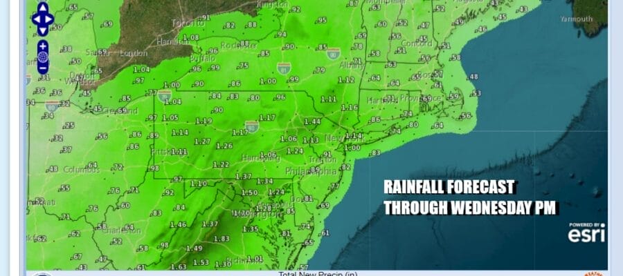
The low in the Plains weakens and as the front sweeps in from the southwest, another low develops along the Mid Atlantic Coast and heads northward Tuesday night and Wednesday. This low will cause rain to break out Tuesday night and that will carry us though most of Wednesday. Temperatures Wednesday will be in the warm 50s.

Once this system pulls away we will have leftover clouds Wednesday night and Thursday and we will begin stair step decline in temperatures. The upper low lags behind and you can see that it shows a hook of rain and snow moving into the Central Appalachians. A new low probably forms offshore but for now it seems that it will see limited development and not much direct impact to our weather for the later part of this week.
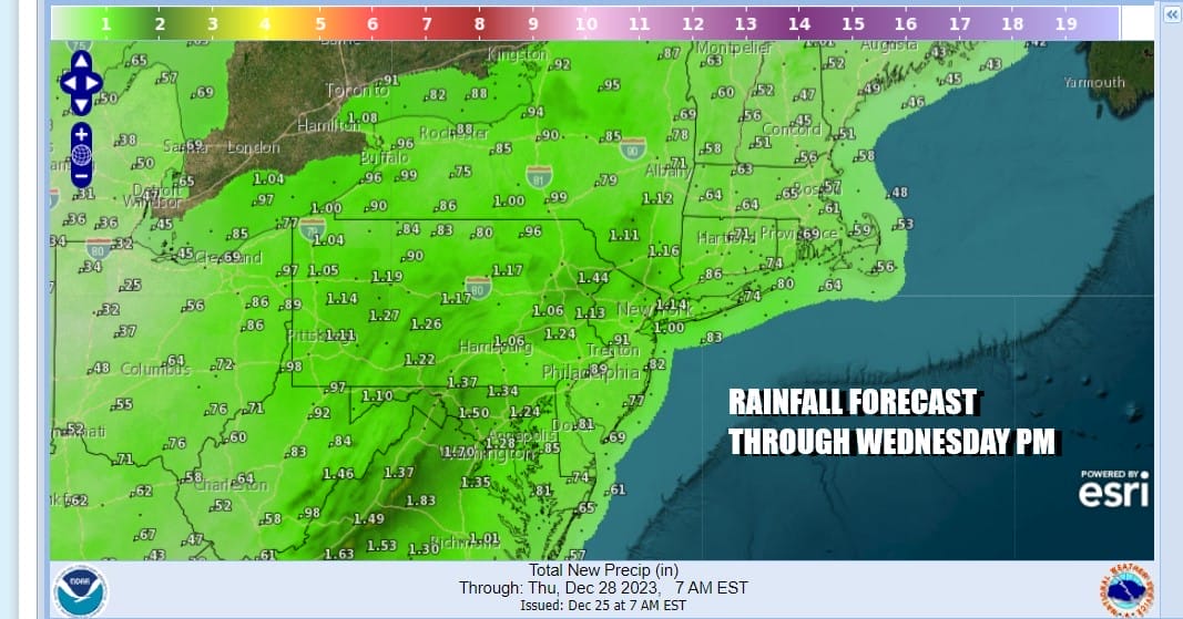
As far as rainfall is concerned, three quarters of an inch to an inch seems reasonable from this Wedensday system. As far as the long range is concerned, the grinding process of pattern change continues and where we wind up with it is anyone’s guess. The overall pattern would favor colder than normal weather in much of the East especially the Mid Atlantic and the South. How this pattern plays out stormwise is anyone’s guess at this stage.
BE SURE TO DOWNLOAD THE FREE METEOROLOGIST JOE CIOFFI WEATHER APP &
ANGRY BEN’S FREE WEATHER APP “THE ANGRY WEATHERMAN!
MANY THANKS TO TROPICAL TIDBITS FOR THE USE OF MAPS
Please note that with regards to any severe weather, tropical storms, or hurricanes, should a storm be threatening, please consult your local National Weather Service office or your local government officials about what action you should be taking to protect life and property.
(Amazon is an affilate of Meteorologist Joe Cioffi & earns commissions on sales.)


